
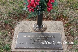
| Birth | : | 8 Mar 1917 Big Creek Township, Stokes County, North Carolina, USA |
| Death | : | 19 Jan 2006 Winston-Salem, Forsyth County, North Carolina, USA |
| Burial | : | Stoney Creek Primitive Baptist Church Cemetery, Holly Springs, Surry County, USA |
| Coordinate | : | 36.4393654, -80.5477219 |
| Description | : | Social Security Death Index about Myrtle W. Calloway: Name: Myrtle W. Calloway Last Residence: 27041 Pilot Mountain, Surry, North Carolina Born: 8 Mar 1917 Died: 19 Jan 2006 State (Year) SSN issued: North Carolina (1974) ----------- PILOT MOUNTAIN, NC ~ Mrs. Myrtle Willard Calloway, 88, of Pilot Mountain, the widow of Jimmy Calloway, passed away at Forsyth Medical Center on Thursday, Jan. 19, 2006. She was born March 8, 1917, in Stokes County to the late John and Mary Cole Willard. Mrs. Calloway was a retired farmer and homemaker and of the Baptist faith. Mount Airy News (NC) ~ January 21, 2006) ---------- . Gurtha Myrtle Willard, the fourth born... Read More |
frequently asked questions (FAQ):
-
Where is Gurtha Myrtle Willard Calloway's memorial?
Gurtha Myrtle Willard Calloway's memorial is located at: Stoney Creek Primitive Baptist Church Cemetery, Holly Springs, Surry County, USA.
-
When did Gurtha Myrtle Willard Calloway death?
Gurtha Myrtle Willard Calloway death on 19 Jan 2006 in Winston-Salem, Forsyth County, North Carolina, USA
-
Where are the coordinates of the Gurtha Myrtle Willard Calloway's memorial?
Latitude: 36.4393654
Longitude: -80.5477219
Family Members:
Parent

Spouse
Siblings
Children
Flowers:


Nearby Cemetories:
1. Simmons Family Cemetery
Mount Airy, Surry County, USA
Coordinate: 36.4452800, -80.5423300
2. Cox Cemetery
Pilot Mountain, Surry County, USA
Coordinate: 36.4306230, -80.5447840
3. Peoples Church Cemetery
Holly Springs, Surry County, USA
Coordinate: 36.4501100, -80.5525000
4. John Anderson Taylor Memorial Cemetery
Pilot Mountain, Surry County, USA
Coordinate: 36.4421600, -80.5238300
5. McGee Cemetery
Mount Airy, Surry County, USA
Coordinate: 36.4550800, -80.5700400
6. Holly Springs Baptist Church Cemetery
Holly Springs, Surry County, USA
Coordinate: 36.4625816, -80.5570297
7. Simmons Grove Baptist Church Cemetery
Pilot Mountain, Surry County, USA
Coordinate: 36.4331180, -80.5175440
8. W.C. Hiatt Cemetery
Mount Airy, Surry County, USA
Coordinate: 36.4484329, -80.5796204
9. Worth Cemetery
Ararat, Surry County, USA
Coordinate: 36.4180130, -80.5205710
10. Watson Cemetery
Ararat, Surry County, USA
Coordinate: 36.4254140, -80.5822060
11. Anchor Baptist Church Cemetery
Ararat, Surry County, USA
Coordinate: 36.4055550, -80.5556050
12. Ararat Cemetery
Ararat, Surry County, USA
Coordinate: 36.4054130, -80.5561350
13. Bryant Chapel Baptist Church Cemetery
Ararat, Surry County, USA
Coordinate: 36.4106840, -80.5728080
14. New Hope Cemetery
Ararat, Surry County, USA
Coordinate: 36.4043890, -80.5428610
15. Lawson and Sawyers Family Cemetery
Ararat, Surry County, USA
Coordinate: 36.4144700, -80.5837500
16. Pine Ridge Presbyterian Church Cemetery
Pilot Mountain, Surry County, USA
Coordinate: 36.4537700, -80.5030000
17. Southside Baptist Church Cemetery
Boones Hill, Surry County, USA
Coordinate: 36.4725280, -80.5729720
18. Simmons Family Cemetery
Pilot Mountain, Surry County, USA
Coordinate: 36.4463110, -80.4982480
19. Charles Beck Family Cemetery
Ararat, Surry County, USA
Coordinate: 36.4147800, -80.5909700
20. Haymore Family Cemetery
Mount Airy, Surry County, USA
Coordinate: 36.4812486, -80.5608610
21. Sulphur Springs Baptist Church Cemetery
Pilot Mountain, Surry County, USA
Coordinate: 36.4074440, -80.5108871
22. Smith Family Cemetery
Mount Airy, Surry County, USA
Coordinate: 36.4773598, -80.5760269
23. Kirkman Family Cemetery
Sheltontown, Surry County, USA
Coordinate: 36.4851110, -80.5421120
24. Skyline Memory Gardens
Mount Airy, Surry County, USA
Coordinate: 36.4745610, -80.5856500