
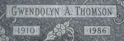
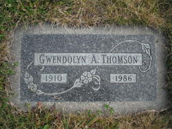
Gwendolyn A. Brown Thomson
| Birth | : | 4 May 1910 Kittson County, Minnesota, USA |
| Death | : | 26 Sep 1986 Libby, Lincoln County, Montana, USA |
| Burial | : | Hokitika Municipal Cemetery, Hokitika, Westland District, New Zealand |
| Coordinate | : | -42.7102940, 170.9759800 |
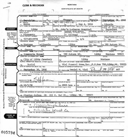
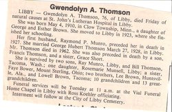
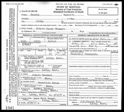
| Description | : | Clow Township is a township in Kittson County, Minnesota, United States. The population was 37 at the 2000 census. Montana, County Births and Deaths Name: Gwendolyn A. Thomson [Gwendolyn A. Brown] Gender: Female Death Age: 76 Birth Date: 4 May 1910 Birth Place: Minnesota Death Date: 26 Sep 1986 Death Place: Libby, Lincoln, Montana Father: George W. Brown Mother: Esther M. Brown Montana, County Marriages, 1865-1950 Name: Gwendolin Brown Gender: Female Age: 28 Birth Date: 1908 Marriage Date: 22 Apr 1926 Marriage... Read More |
frequently asked questions (FAQ):
-
Where is Gwendolyn A. Brown Thomson's memorial?
Gwendolyn A. Brown Thomson's memorial is located at: Hokitika Municipal Cemetery, Hokitika, Westland District, New Zealand.
-
When did Gwendolyn A. Brown Thomson death?
Gwendolyn A. Brown Thomson death on 26 Sep 1986 in Libby, Lincoln County, Montana, USA
-
Where are the coordinates of the Gwendolyn A. Brown Thomson's memorial?
Latitude: -42.7102940
Longitude: 170.9759800
Family Members:
Parent
Spouse
Siblings
Children


Nearby Cemetories:
1. Hokitika Municipal Cemetery
Hokitika, Westland District, New Zealand
Coordinate: -42.7102940, 170.9759800
2. Old Stafford Cemetery
Hokitika, Westland District, New Zealand
Coordinate: -42.6662370, 171.0893140
3. Kumara Cemetery
Kumara, Westland District, New Zealand
Coordinate: -42.6464650, 171.1721970
4. Ross Cemetery
Ross, Westland District, New Zealand
Coordinate: -42.8898440, 170.8226160
5. Gladstone Cemetery
Greymouth, Grey District, New Zealand
Coordinate: -42.5381220, 171.1522540
6. Ross Historic Cemetery
Ross, Westland District, New Zealand
Coordinate: -42.9023200, 170.8113230
7. Greenstone Cemetery
Kumara, Westland District, New Zealand
Coordinate: -42.6361450, 171.2751350
8. Karoro Cemetery
Greymouth, Grey District, New Zealand
Coordinate: -42.4678260, 171.1893800
9. St Pauls Methodist Church (Defunct)
Greymouth, Grey District, New Zealand
Coordinate: -42.4500880, 171.2114610
10. Cobden Cemetery
Greymouth, Grey District, New Zealand
Coordinate: -42.4371700, 171.2019000
11. Stillwater Cemetery
Greymouth, Grey District, New Zealand
Coordinate: -42.4394820, 171.3494380
12. Notown Cemetery
Dobson, Grey District, New Zealand
Coordinate: -42.4514530, 171.4465670
13. Blackball Cemetery
Greymouth, Grey District, New Zealand
Coordinate: -42.3757410, 171.4135760
14. Evans Grave
Arthurs Pass, Selwyn District, New Zealand
Coordinate: -42.7723610, 171.6249940
15. Nelson Creek Cemetery
Ngahere, Grey District, New Zealand
Coordinate: -42.3865620, 171.4595500
16. Barrytown Cemetery
Barrytown, Grey District, New Zealand
Coordinate: -42.2455150, 171.3166710
17. Hari Hari Cemetery
Hari Hari, Westland District, New Zealand
Coordinate: -43.1501430, 170.5576110
18. Ahaura Cemetery
Ahaura, Grey District, New Zealand
Coordinate: -42.3516790, 171.5581700
19. Whataroa Cemetery
Whataroa, Westland District, New Zealand
Coordinate: -43.2530190, 170.3587130
20. Lake Coleridge Cemetery
Lake Coleridge, Selwyn District, New Zealand
Coordinate: -43.3695530, 171.5264300
21. Charleston Catholic Cemetery
Charleston, Buller District, New Zealand
Coordinate: -41.9093390, 171.4359110
22. Nile Hill Cemetery
Charleston, Buller District, New Zealand
Coordinate: -41.8991610, 171.4394080
23. Old Reefton Cemetery
Reefton, Buller District, New Zealand
Coordinate: -42.1115220, 171.8590850
24. Reefton Cemetery
Reefton, Buller District, New Zealand
Coordinate: -42.0856940, 171.8470730