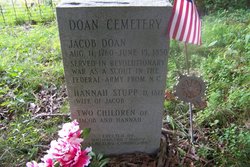
Hannah Stupp Doan
| Birth | : | 1765 North Carolina, USA |
| Death | : | 1817 Hardinsburg, Washington County, Indiana, USA |
| Burial | : | St Mary the Virgin Churchyard, Aldeby, South Norfolk District, England |
| Coordinate | : | 52.4826360, 1.6075660 |
| Description | : | Married to Jacob Doan; probably married in NC. |
frequently asked questions (FAQ):
-
Where is Hannah Stupp Doan's memorial?
Hannah Stupp Doan's memorial is located at: St Mary the Virgin Churchyard, Aldeby, South Norfolk District, England.
-
When did Hannah Stupp Doan death?
Hannah Stupp Doan death on 1817 in Hardinsburg, Washington County, Indiana, USA
-
Where are the coordinates of the Hannah Stupp Doan's memorial?
Latitude: 52.4826360
Longitude: 1.6075660
Family Members:
Spouse
Children
Flowers:
Nearby Cemetories:
1. St Mary the Virgin Churchyard
Aldeby, South Norfolk District, England
Coordinate: 52.4826360, 1.6075660
2. All Saints Churchyard
Worlingham, Waveney District, England
Coordinate: 52.4517300, 1.5969000
3. St. Mary's Churchyard
Haddiscoe, South Norfolk District, England
Coordinate: 52.5153200, 1.5939300
4. St. Botolph Churchyard
North Cove, Waveney District, England
Coordinate: 52.4474411, 1.6227847
5. St Mary's Churchyard
Gillingham, South Norfolk District, England
Coordinate: 52.4750343, 1.5489500
6. St. Michael's Churchyard
Beccles, Waveney District, England
Coordinate: 52.4585640, 1.5621960
7. All Saints Churchyard
Gillingham, South Norfolk District, England
Coordinate: 52.4753720, 1.5479546
8. Kilbrack Cemetery
Beccles, Waveney District, England
Coordinate: 52.4535653, 1.5686063
9. St Mary's Churchyard
Burgh St Peter, South Norfolk District, England
Coordinate: 52.4840860, 1.6710830
10. Saint John the Baptist Churchyard
Barnby, Waveney District, England
Coordinate: 52.4510410, 1.6494740
11. St. Benet Churchyard
Beccles, Waveney District, England
Coordinate: 52.4540391, 1.5592873
12. Beccles Cemetery
Beccles, Waveney District, England
Coordinate: 52.4486092, 1.5604172
13. Thorpe-next-Haddiscoe St Mathias Churchyard
Haddiscoe, South Norfolk District, England
Coordinate: 52.5261880, 1.5896380
14. St Margaret's Churchyard
Herringfleet, Waveney District, England
Coordinate: 52.5218820, 1.6493630
15. St Michael Churchyard
Geldeston, South Norfolk District, England
Coordinate: 52.4759460, 1.5246070
16. Waveney Memorial Park and Crematorium
Ellough, Waveney District, England
Coordinate: 52.4314090, 1.6151750
17. St Mary Churchyard
Somerleyton, Waveney District, England
Coordinate: 52.5157800, 1.6730900
18. St. Andrew's Churchyard
Mutford, Waveney District, England
Coordinate: 52.4387060, 1.6566540
19. St. Michael's Churchyard
Oulton, Waveney District, England
Coordinate: 52.4823570, 1.6952900
20. St Andrews Churchyard
Raveningham, South Norfolk District, England
Coordinate: 52.5126430, 1.5323570
21. St Olave's Priory
Herringfleet, Waveney District, England
Coordinate: 52.5381200, 1.6240290
22. Holy Trinity Churchyard
Barsham, Waveney District, England
Coordinate: 52.4520000, 1.5263000
23. Methodist Churchyard
Norton Subcourse, North Norfolk District, England
Coordinate: 52.5317630, 1.5557020
24. St. Peter's Churchyard
Weston, Waveney District, England
Coordinate: 52.4281030, 1.5714350


