
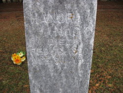
Hanora Hogan Mack
| Birth | : | 1835 Ireland |
| Death | : | 16 Feb 1920 Allamakee County, Iowa, USA |
| Burial | : | Hermiston Cemetery, Hermiston, Umatilla County, USA |
| Coordinate | : | 45.8236008, -119.2806015 |
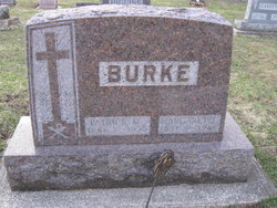
| Description | : | To find this monument: Crucifix in center separates front and back half, this monument can be found in the back half of the front half. Or go to the crucifix in the center of the cemetery and start searching in front of the crucifix. Feel free to contact me to make any additions or corrections. |
frequently asked questions (FAQ):
-
Where is Hanora Hogan Mack's memorial?
Hanora Hogan Mack's memorial is located at: Hermiston Cemetery, Hermiston, Umatilla County, USA.
-
When did Hanora Hogan Mack death?
Hanora Hogan Mack death on 16 Feb 1920 in Allamakee County, Iowa, USA
-
Where are the coordinates of the Hanora Hogan Mack's memorial?
Latitude: 45.8236008
Longitude: -119.2806015
Family Members:
Spouse
Children
Flowers:


Nearby Cemetories:
1. Hermiston Cemetery
Hermiston, Umatilla County, USA
Coordinate: 45.8236008, -119.2806015
2. Pleasant View Cemetery
Stanfield, Umatilla County, USA
Coordinate: 45.7943993, -119.2022018
3. Baumgardner Cemetery
Umatilla County, USA
Coordinate: 45.7625008, -119.2332993
4. Foster Cemetery
Stanfield Junction, Umatilla County, USA
Coordinate: 45.7672005, -119.2114029
5. Sunset Hills Cemetery
Umatilla, Umatilla County, USA
Coordinate: 45.9077988, -119.3507996
6. Echo Memorial Cemetery
Echo, Umatilla County, USA
Coordinate: 45.7472000, -119.1931000
7. Fort Henrietta Burial Site
Echo, Umatilla County, USA
Coordinate: 45.7419300, -119.1975500
8. Pioneer Memorial Cemetery
Umatilla, Umatilla County, USA
Coordinate: 45.9164009, -119.3486023
9. Koontz Gravesite
Umatilla County, USA
Coordinate: 45.7365700, -119.1880000
10. Stanfield Hutterite Cemetery
Stanfield, Umatilla County, USA
Coordinate: 45.8271307, -119.0798728
11. Desert Lawn Memorial Cemetery
Irrigon, Morrow County, USA
Coordinate: 45.8972015, -119.4721985
12. Nolin Cemetery
Umatilla County, USA
Coordinate: 45.6833000, -119.1027985
13. Paterson Memorial Cemetery
Paterson, Benton County, USA
Coordinate: 45.9437943, -119.5705566
14. Yarlett Cemetery
Pine City, Morrow County, USA
Coordinate: 45.6077919, -119.4255066
15. Holdman Cemetery
Holdman, Umatilla County, USA
Coordinate: 45.8744011, -118.9443970
16. Despain Gulch Cemetery
Umatilla County, USA
Coordinate: 45.7611008, -118.9124985
17. Riverview Cemetery
Boardman, Morrow County, USA
Coordinate: 45.8493996, -119.6939011
18. Sand Hollow Cemetery
Lexington, Morrow County, USA
Coordinate: 45.5597115, -119.5014572
19. Wells Springs Cemetery
Morrow County, USA
Coordinate: 45.6323395, -119.7066269
20. Eastern Oregon State Hospital Cemetery
Pendleton, Umatilla County, USA
Coordinate: 45.6719700, -118.8179500
21. Horse Heaven Hills Cemetery
Benton County, USA
Coordinate: 46.1551018, -119.4826736
22. Wallula Cemetery
Wallula, Walla Walla County, USA
Coordinate: 46.0844400, -118.8997200
23. Olney Cemetery
Pendleton, Umatilla County, USA
Coordinate: 45.6589012, -118.8031006
24. Pioneer Park Cemetery
Pendleton, Umatilla County, USA
Coordinate: 45.6743000, -118.7917000