
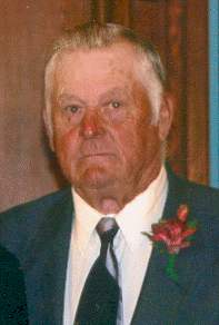
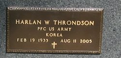

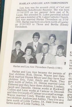


Harlan Wayne Throndson
| Birth | : | 19 Feb 1933 Lawler, Chickasaw County, Iowa, USA |
| Death | : | 11 Aug 2005 Lawler, Chickasaw County, Iowa, USA |
| Burial | : | Westlawn-Hillcrest Memorial Park, Omaha, Douglas County, USA |
| Coordinate | : | 41.2346992, -95.9966965 |
| Description | : | Son of Thrond Anthony & Bertha (Ehert) Throndson. Married Lou Ann Baumler on May 14, 1956 in St. Lucas. Father of Rick, Wayne, Dale & Denise. |
frequently asked questions (FAQ):
-
Where is Harlan Wayne Throndson's memorial?
Harlan Wayne Throndson's memorial is located at: Westlawn-Hillcrest Memorial Park, Omaha, Douglas County, USA.
-
When did Harlan Wayne Throndson death?
Harlan Wayne Throndson death on 11 Aug 2005 in Lawler, Chickasaw County, Iowa, USA
-
Where are the coordinates of the Harlan Wayne Throndson's memorial?
Latitude: 41.2346992
Longitude: -95.9966965
Family Members:
Parent

Spouse

Siblings

Flowers:

Rest in sweet heavenly peace.
Left by Anonymous on 12 Aug 2005

You were a good friend to my father, Walter J Schmidt. Rest in peace.
Left by Anonymous on 08 Jul 2011

? L??? ? ? At one point in your life, you wrote a blank check made payable to The United States of America, for an amount up to, and including your life if necessary. Thank you for your sacrifice and service to our country. God bless you!? L??? ? ?
Left by Anonymous on 16 May 2021


Nearby Cemetories:
1. Westlawn-Hillcrest Memorial Park
Omaha, Douglas County, USA
Coordinate: 41.2346992, -95.9966965
2. Bohemian Cemetery
Omaha, Douglas County, USA
Coordinate: 41.2388992, -95.9955978
3. Ak-Sar-Ben Racetrack Grounds
Omaha, Douglas County, USA
Coordinate: 41.2414703, -96.0159607
4. Douglas County Poor Farm Cemetery
Omaha, Douglas County, USA
Coordinate: 41.2437240, -95.9723480
5. Holy Sepulchre Cemetery
Omaha, Douglas County, USA
Coordinate: 41.2543983, -95.9875031
6. Calvary Cemetery
Omaha, Douglas County, USA
Coordinate: 41.2364006, -96.0294037
7. Graceland Park Cemetery
Omaha, Douglas County, USA
Coordinate: 41.2113991, -95.9785995
8. Evergreen Memorial Park Cemetery
Omaha, Douglas County, USA
Coordinate: 41.2393990, -96.0355988
9. Resurrection Cemetery
Omaha, Douglas County, USA
Coordinate: 41.2344208, -96.0365448
10. First Central Congregational Columbarium
Omaha, Douglas County, USA
Coordinate: 41.2563456, -95.9658365
11. Saint Mary Magdalene Cemetery
Omaha, Douglas County, USA
Coordinate: 41.2039420, -95.9850610
12. Nash Chapel Crypt
Omaha, Douglas County, USA
Coordinate: 41.2665090, -95.9721790
13. Saint Andrews Episcopal Church Columbarium
Omaha, Douglas County, USA
Coordinate: 41.2492500, -96.0427500
14. Saint Mary's Cemetery
Omaha, Douglas County, USA
Coordinate: 41.2042007, -95.9646988
15. Beth El Cemetery
Ralston, Douglas County, USA
Coordinate: 41.2117004, -96.0428009
16. Countryside Community Church Columbarium
Omaha, Douglas County, USA
Coordinate: 41.2483660, -96.0500270
17. Trinity Cathedral Columbarium
Omaha, Douglas County, USA
Coordinate: 41.2603900, -95.9393660
18. Prospect Hill Cemetery
Omaha, Douglas County, USA
Coordinate: 41.2780991, -95.9593964
19. Saint Johns Cemetery
Bellevue, Sarpy County, USA
Coordinate: 41.1864014, -95.9682999
20. Laurel Hill Cemetery
Omaha, Douglas County, USA
Coordinate: 41.1918983, -95.9417038
21. All Saints Episcopal Church Columbarium
Omaha, Douglas County, USA
Coordinate: 41.2785000, -96.0579000
22. Fisher Farm Cemetery
Bellevue, Sarpy County, USA
Coordinate: 41.1727982, -95.9760971
23. Hrabik Cemetery
Bellevue, Sarpy County, USA
Coordinate: 41.1726540, -95.9768200
24. Papillion Cemetery
Papillion, Sarpy County, USA
Coordinate: 41.1758003, -96.0410995