
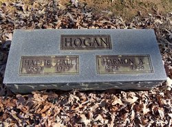

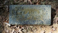
Harmon Alexander Hogan
| Birth | : | 30 Jan 1879 Searcy County, Arkansas, USA |
| Death | : | 1958 Arkansas, USA |
| Burial | : | St Mary Churchyard, Tatsfield, Tandridge District, England |
| Coordinate | : | 51.2867530, 0.0309620 |
| Description | : | Double stone with wife Hattie Hall Hogan 1889-1979 |
frequently asked questions (FAQ):
-
Where is Harmon Alexander Hogan's memorial?
Harmon Alexander Hogan's memorial is located at: St Mary Churchyard, Tatsfield, Tandridge District, England.
-
When did Harmon Alexander Hogan death?
Harmon Alexander Hogan death on 1958 in Arkansas, USA
-
Where are the coordinates of the Harmon Alexander Hogan's memorial?
Latitude: 51.2867530
Longitude: 0.0309620
Family Members:
Spouse

Children
Flowers:


Nearby Cemetories:
1. St Mary Churchyard
Tatsfield, Tandridge District, England
Coordinate: 51.2867530, 0.0309620
2. St James Churchyard
Titsey, Tandridge District, England
Coordinate: 51.2763810, 0.0186740
3. Biggin Hill Cemetery
Biggin Hill, London Borough of Bromley, England
Coordinate: 51.3148350, 0.0360920
4. St Peter Churchyard
Limpsfield, Tandridge District, England
Coordinate: 51.2609596, 0.0123030
5. St Mary the Virgin Churchyard
Westerham, Sevenoaks District, England
Coordinate: 51.2675000, 0.0734930
6. St. Leonard's Churchyard
Chelsham, Tandridge District, England
Coordinate: 51.3134100, -0.0083000
7. St Mary the Virgin Churchyard
Oxted, Tandridge District, England
Coordinate: 51.2590680, -0.0086690
8. St Peter and St Paul Churchyard
Cudham, London Borough of Bromley, England
Coordinate: 51.3203280, 0.0721780
9. St. Agatha Churchyard
Woldingham, Tandridge District, England
Coordinate: 51.2771930, -0.0350300
10. St Martin Churchyard
Brasted, Sevenoaks District, England
Coordinate: 51.2794480, 0.1043810
11. Greenlawn Memorial Park
Warlingham, Tandridge District, England
Coordinate: 51.3079900, -0.0395000
12. St Mary the Virgin Churchyard
Downe, London Borough of Bromley, England
Coordinate: 51.3358880, 0.0543840
13. St Katharine Churchyard
Knockholt, Sevenoaks District, England
Coordinate: 51.3105200, 0.1046060
14. Convent of the Sacred Heart Cemetery
Woldingham, Tandridge District, England
Coordinate: 51.2755490, -0.0508110
15. Chartwell
Edenbridge, Sevenoaks District, England
Coordinate: 51.2443430, 0.0833630
16. St Marys Churchyard
Farleigh, Tandridge District, England
Coordinate: 51.3233709, -0.0320591
17. St Peter Churchyard
Tandridge, Tandridge District, England
Coordinate: 51.2429480, -0.0320950
18. All Saints Churchyard
Warlingham, Tandridge District, England
Coordinate: 51.3133408, -0.0557738
19. St. Mary's Churchyard
Keston, London Borough of Bromley, England
Coordinate: 51.3483200, 0.0353850
20. St Mary Churchyard
Sundridge, Sevenoaks District, England
Coordinate: 51.2743360, 0.1292510
21. St Botolph Churchyard
Chevening, Sevenoaks District, England
Coordinate: 51.2987650, 0.1345180
22. Chevening Parish Burial Ground
Chevening, Sevenoaks District, England
Coordinate: 51.2987450, 0.1356290
23. Saint Nicholas Churchyard
Godstone, Tandridge District, England
Coordinate: 51.2465740, -0.0567650
24. Caterham Cemetery
Caterham, Tandridge District, England
Coordinate: 51.2824240, -0.0846160