


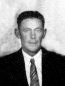

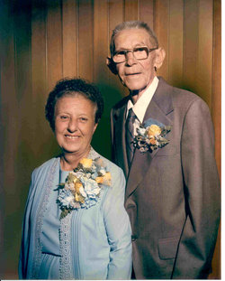
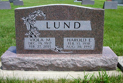
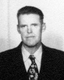
Harold Edwin Lund
| Birth | : | 15 Feb 1910 Magnet, Cedar County, Nebraska, USA |
| Death | : | 30 Aug 1992 Mitchell, Davison County, South Dakota, USA |
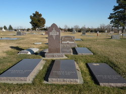
| Burial | : | Blair Cemetery, Campton, Grafton County, USA |
| Coordinate | : | 43.8111000, -71.6603012 |
| Plot | : | Block 5, Lot 44, Grave 2 |
| Description | : | Buried on Sept. 5, 1992. Married Viola Stevicks on Aug. 9, 1936 in Gregory county, Burke, SD. Parents of Shirley Ann, Larry Lee, Barbara Ann, Richard Lee. |
frequently asked questions (FAQ):
-
Where is Harold Edwin Lund's memorial?
Harold Edwin Lund's memorial is located at: Blair Cemetery, Campton, Grafton County, USA.
-
When did Harold Edwin Lund death?
Harold Edwin Lund death on 30 Aug 1992 in Mitchell, Davison County, South Dakota, USA
-
Where are the coordinates of the Harold Edwin Lund's memorial?
Latitude: 43.8111000
Longitude: -71.6603012
Family Members:
Parent

Spouse
Siblings


Flowers:


Nearby Cemetories:
1. Blair Cemetery
Campton, Grafton County, USA
Coordinate: 43.8111000, -71.6603012
2. Bog Road Cemetery
Campton, Grafton County, USA
Coordinate: 43.8152149, -71.6666793
3. Blaisdell Cemetery
Campton, Grafton County, USA
Coordinate: 43.8169440, -71.6555560
4. Campton Hollow Cemetery
Campton Hollow, Grafton County, USA
Coordinate: 43.8238150, -71.6409440
5. Beech Hill Burying Ground
Campton, Grafton County, USA
Coordinate: 43.8000620, -71.7119690
6. Eastern Corner Road Cemetery
Campton, Grafton County, USA
Coordinate: 43.8177540, -71.6045920
7. Riverside Cemetery
Plymouth, Grafton County, USA
Coordinate: 43.7736000, -71.6908100
8. Partridge Hill Cemetery
West Campton, Grafton County, USA
Coordinate: 43.8428700, -71.7046900
9. Town Line Cemetery
Campton, Grafton County, USA
Coordinate: 43.8614570, -71.6678870
10. Trinity Churchyard Cemetery
Holderness, Grafton County, USA
Coordinate: 43.7566000, -71.6696700
11. Campton Village Cemetery
Campton, Grafton County, USA
Coordinate: 43.8654440, -71.6364380
12. West Campton Cemetery
Grafton County, USA
Coordinate: 43.8622220, -71.7052780
13. Sanborn Cemetery
Holderness, Grafton County, USA
Coordinate: 43.7612800, -71.6050600
14. East Rumney
Rumney, Grafton County, USA
Coordinate: 43.8236110, -71.7483330
15. Church Hill Cemetery
Ashland, Grafton County, USA
Coordinate: 43.7455560, -71.6522220
16. Pleasant Valley Cemetery
Plymouth, Grafton County, USA
Coordinate: 43.7741300, -71.7364600
17. Dearborn Cemetery
Plymouth, Grafton County, USA
Coordinate: 43.7597220, -71.7213890
18. Shaw Cemetery
Holderness, Grafton County, USA
Coordinate: 43.7436110, -71.6225000
19. Spencer Cemetery
Grafton County, USA
Coordinate: 43.7720080, -71.7455500
20. Calvary Independent Baptist Church Cemetery
Plymouth, Grafton County, USA
Coordinate: 43.7639220, -71.7484290
21. Lower Intervale Cemetery
Plymouth, Grafton County, USA
Coordinate: 43.7316100, -71.6733800
22. Owl Brook Cemetery
Ashland, Grafton County, USA
Coordinate: 43.7333200, -71.6300100
23. Mad River Cemetery
Thornton, Grafton County, USA
Coordinate: 43.8833670, -71.6077500
24. True Cemetery
Holderness, Grafton County, USA
Coordinate: 43.7819440, -71.5538890