
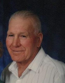
| Birth | : | 23 May 1922 Aden, Medicine Hat Census Division, Alberta, Canada |
| Death | : | 13 Dec 1995 Pincher Creek, Claresholm Census Division, Alberta, Canada |
| Burial | : | Cowley Cemetery, Cowley, Claresholm Census Division, Canada |
| Coordinate | : | 49.5906800, -114.0943900 |
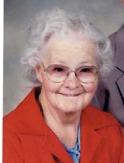
| Inscription | : | In Loving Memory OF HAROLD E. HAUGEN 1922 - 1995 And His Wife MARJORIE 1921 - 2008 Love is Eternal |
| Description | : | Harold was born in Aden, Alberta wheee he attended the local school, traveling on horseback, until he had completed grade eight. Harold went to the Deer Creek Ranch until joining the army Tank Corps. He was only in Europe for a few months when he received an honourable discharge because of a bad back, and returned to work at the Gilchrist Ranch, then the Porcupine Hills in 1946. He met Marjorie Wilkins, a schoolteacher, in 1948 and they were married Easter 1949 in St. Aidan’s Anglican Church in Cowley. Harold purchased the ESSO Station in Cowley in the mid-50’s... Read More |
frequently asked questions (FAQ):
-
Where is Harold Everett Haugen's memorial?
Harold Everett Haugen's memorial is located at: Cowley Cemetery, Cowley, Claresholm Census Division, Canada.
-
When did Harold Everett Haugen death?
Harold Everett Haugen death on 13 Dec 1995 in Pincher Creek, Claresholm Census Division, Alberta, Canada
-
Where are the coordinates of the Harold Everett Haugen's memorial?
Latitude: 49.5906800
Longitude: -114.0943900
Family Members:
Parent
Spouse

Siblings


Nearby Cemetories:
1. Cowley Cemetery
Cowley, Claresholm Census Division, Canada
Coordinate: 49.5906800, -114.0943900
2. United Doukhobors of Alberta Cemetery
Lundbreck, Claresholm Census Division, Canada
Coordinate: 49.5768410, -114.1484240
3. Livingstone Hutterite Colony Cemetery
Lundbreck, Claresholm Census Division, Canada
Coordinate: 49.6498659, -114.1594770
4. Livingstone Cemetery
Cowley, Claresholm Census Division, Canada
Coordinate: 49.6839800, -114.1144500
5. Pincher Creek Colony
Pincher Creek, Claresholm Census Division, Canada
Coordinate: 49.5047220, -113.9947220
6. Pioneer Cemetery
Pincher Creek, Claresholm Census Division, Canada
Coordinate: 49.4944000, -113.9404000
7. Fairview Cemetery
Pincher Creek, Claresholm Census Division, Canada
Coordinate: 49.4935700, -113.9231800
8. Passburg Cemetery
Crowsnest Pass, Canmore Census Division, Canada
Coordinate: 49.5631230, -114.3387240
9. Bellevue Union Cemetery
Crowsnest Pass, Canmore Census Division, Canada
Coordinate: 49.5804710, -114.3643875
10. Saint Cyril's Catholic Cemetery
Crowsnest Pass, Canmore Census Division, Canada
Coordinate: 49.5873230, -114.3788040
11. Hillcrest Cemetery
Crowsnest Pass, Canmore Census Division, Canada
Coordinate: 49.5757290, -114.3799920
12. Frank Cemetery
Crowsnest Pass, Canmore Census Division, Canada
Coordinate: 49.5970300, -114.3860400
13. Pincher Creek Mennonite Brethren Cemetery
Pincher Creek, Claresholm Census Division, Canada
Coordinate: 49.4699090, -113.8627370
14. The Frank Slide
Crowsnest Pass, Canmore Census Division, Canada
Coordinate: 49.5924431, -114.3940019
15. Frank Slide Memorial Cemetery
Crowsnest Pass, Canmore Census Division, Canada
Coordinate: 49.5936535, -114.3997562
16. Lille Cemetery
Crowsnest Pass, Canmore Census Division, Canada
Coordinate: 49.6459650, -114.3928460
17. Spring Point Hutterite Cemetery
Pincher Creek, Claresholm Census Division, Canada
Coordinate: 49.6843639, -113.8070451
18. Trinity Lutheran Cemetery
Pincher Creek, Claresholm Census Division, Canada
Coordinate: 49.4070670, -113.9263560
19. Brocket Cemetery
Brocket, Claresholm Census Division, Canada
Coordinate: 49.5457100, -113.7667700
20. Old Blairmore Union Cemetery
Crowsnest Pass, Canmore Census Division, Canada
Coordinate: 49.6117400, -114.4343000
21. Saint Annes Roman Catholic Cemetery
Crowsnest Pass, Canmore Census Division, Canada
Coordinate: 49.6119900, -114.4369000
22. New Blairmore Union Cemetery
Crowsnest Pass, Canmore Census Division, Canada
Coordinate: 49.6126700, -114.4387650
23. Bratton Family Cemetery
Spring Point, Claresholm Census Division, Canada
Coordinate: 49.7150200, -113.8017500
24. Brocket Colony Cemetery
Pincher Creek, Claresholm Census Division, Canada
Coordinate: 49.4655200, -113.7694100