
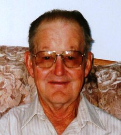


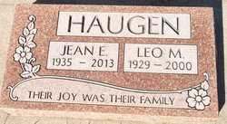
Leo Melvin Haugen
| Birth | : | 10 Jul 1929 Alberta, Canada |
| Death | : | 17 Sep 2000 Alberta, Canada |
| Burial | : | Claresholm Cemetery, Claresholm, Claresholm Census Division, Canada |
| Coordinate | : | 50.0114784, -113.5946503 |
| Description | : | The 7th child of Ole and Margaret Haugen, and raised on the farm near Aden, Alberta, Leo was used to hard work all of his life. He helped neighbours with haying, chores and general farm work. As time went on and Leo worked on several farms or ranches from Aden to Pincher Creek to High River and places in between. He also worked at the Raymond Sugar Factory for a couple of seasons and did some house building as well. In the early 1950’s Leo met and married Jeannine Bell and moved to the original Bell homestead. From that time on... Read More |
frequently asked questions (FAQ):
-
Where is Leo Melvin Haugen's memorial?
Leo Melvin Haugen's memorial is located at: Claresholm Cemetery, Claresholm, Claresholm Census Division, Canada.
-
When did Leo Melvin Haugen death?
Leo Melvin Haugen death on 17 Sep 2000 in Alberta, Canada
-
Where are the coordinates of the Leo Melvin Haugen's memorial?
Latitude: 50.0114784
Longitude: -113.5946503
Family Members:
Parent
Spouse
Siblings

Flowers:


Nearby Cemetories:
1. Claresholm Cemetery
Claresholm, Claresholm Census Division, Canada
Coordinate: 50.0114784, -113.5946503
2. Five Mile Cemetery
Claresholm, Claresholm Census Division, Canada
Coordinate: 50.0188250, -113.4705730
3. Saint Peter's Lutheran Cemetery
Claresholm, Claresholm Census Division, Canada
Coordinate: 50.0487620, -113.4822460
4. Granum Cemetery
Granum, Claresholm Census Division, Canada
Coordinate: 49.8812800, -113.5251600
5. Stavely Cemetery
Stavely, Claresholm Census Division, Canada
Coordinate: 50.1646700, -113.6625600
6. Stavely Cemetery Cremation Cairn
Stavely, Claresholm Census Division, Canada
Coordinate: 50.1646700, -113.6625600
7. Granum Hutterite Cemetery
Granum, Claresholm Census Division, Canada
Coordinate: 49.8513248, -113.6038772
8. Saint Vincent Roman Catholic Cemetery
Stavely, Claresholm Census Division, Canada
Coordinate: 50.1717670, -113.6409830
9. Granum Christian Reformed Church Cemetery
Granum, Claresholm Census Division, Canada
Coordinate: 49.8622100, -113.3436600
10. Elinor Cemetery
Barons, Lethbridge Census Division, Canada
Coordinate: 50.0271520, -113.2340240
11. Jumbo Valley Hutterite Cemetery
Granum, Claresholm Census Division, Canada
Coordinate: 49.8452911, -113.3425358
12. Little Bow Hutterite Cemetery
Stavely, Claresholm Census Division, Canada
Coordinate: 50.2142141, -113.3694417
13. White Lake Hutterite Cemetery
Nobleford, Lethbridge Census Division, Canada
Coordinate: 49.9154153, -113.2084160
14. White Lake Cemetery
Nobleford, Lethbridge Census Division, Canada
Coordinate: 49.9018700, -113.2107750
15. Alston Cemetery
Vulcan, Strathmore Census Division, Canada
Coordinate: 50.1652820, -113.2450470
16. Isol Russell Grave
Champion, Strathmore Census Division, Canada
Coordinate: 50.1792300, -113.2102100
17. Fath Hill Catholic Cemetery
Champion, Strathmore Census Division, Canada
Coordinate: 50.2153400, -113.2544200
18. Carmangay Cemetery
Carmangay, Strathmore Census Division, Canada
Coordinate: 50.1214300, -113.1434300
19. Union Cemetery
Fort Macleod, Claresholm Census Division, Canada
Coordinate: 49.7306500, -113.3882000
20. Holy Cross Cemetery
Fort Macleod, Claresholm Census Division, Canada
Coordinate: 49.7283000, -113.3882400
21. Barons Cemetery
Barons, Lethbridge Census Division, Canada
Coordinate: 49.9756500, -113.0993100
22. Bratton Family Cemetery
Spring Point, Claresholm Census Division, Canada
Coordinate: 49.7150200, -113.8017500
23. Nanton Town Cemetery
Nanton, Claresholm Census Division, Canada
Coordinate: 50.3333800, -113.7586100
24. Orton Cemetery
Orton, Claresholm Census Division, Canada
Coordinate: 49.7484600, -113.2540900