
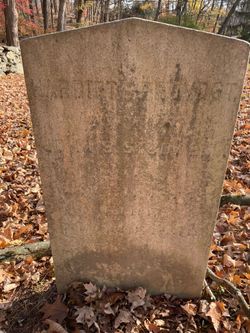
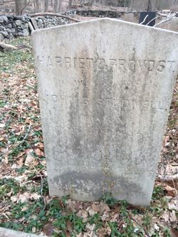
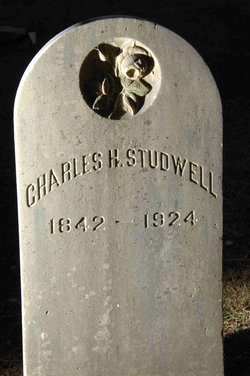
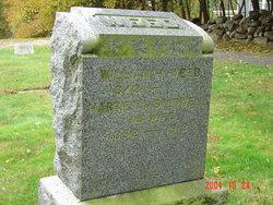
Harriet Elizabeth Provost Studwell
| Birth | : | 31 Dec 1815 |
| Death | : | 23 Dec 1900 |
| Burial | : | St Bartholomews Churchyard, Eastoft, North Lincolnshire Unitary Authority, England |
| Coordinate | : | 53.6397700, -0.7823500 |
frequently asked questions (FAQ):
-
Where is Harriet Elizabeth Provost Studwell's memorial?
Harriet Elizabeth Provost Studwell's memorial is located at: St Bartholomews Churchyard, Eastoft, North Lincolnshire Unitary Authority, England.
-
When did Harriet Elizabeth Provost Studwell death?
Harriet Elizabeth Provost Studwell death on 23 Dec 1900 in
-
Where are the coordinates of the Harriet Elizabeth Provost Studwell's memorial?
Latitude: 53.6397700
Longitude: -0.7823500
Family Members:
Spouse
Children

Flowers:


Nearby Cemetories:
1. St Bartholomews Churchyard
Eastoft, North Lincolnshire Unitary Authority, England
Coordinate: 53.6397700, -0.7823500
2. St Oswald Church
Luddington, North Lincolnshire Unitary Authority, England
Coordinate: 53.6448740, -0.7387490
3. Crowle Cemetery
Crowle, North Lincolnshire Unitary Authority, England
Coordinate: 53.6090660, -0.8285680
4. Crowle Baptist Church
Crowle, North Lincolnshire Unitary Authority, England
Coordinate: 53.6093970, -0.8317350
5. St Oswald Churchyard
Crowle, North Lincolnshire Unitary Authority, England
Coordinate: 53.6077330, -0.8353940
6. St Mary the Virgin Church
Fockerby, North Lincolnshire Unitary Authority, England
Coordinate: 53.6613050, -0.7138730
7. St Marks Church
Amcotts, North Lincolnshire Unitary Authority, England
Coordinate: 53.6166950, -0.7088900
8. All Saints Churchyard
Adlingfleet, East Riding of Yorkshire Unitary Authority, England
Coordinate: 53.6786760, -0.7238110
9. St Andrew's Church
Burton upon Stather, North Lincolnshire Unitary Authority, England
Coordinate: 53.6501180, -0.6850550
10. All Saints' Churchyard
Flixborough, North Lincolnshire Unitary Authority, England
Coordinate: 53.6247100, -0.6819480
11. All Saints Churchyard Old
Flixborough, North Lincolnshire Unitary Authority, England
Coordinate: 53.6178950, -0.6754930
12. St Oswald Churchyard
Althorpe, North Lincolnshire Unitary Authority, England
Coordinate: 53.5765570, -0.7408910
13. St John The Baptist Churchyard Extension
Burringham, North Lincolnshire Unitary Authority, England
Coordinate: 53.5708230, -0.7439800
14. Holy Trinity Churchyard
Blacktoft, East Riding of Yorkshire Unitary Authority, England
Coordinate: 53.7082510, -0.7271700
15. Alkborough Cemetery
Alkborough, North Lincolnshire Unitary Authority, England
Coordinate: 53.6816460, -0.6686090
16. St Peter Churchyard and Church Cemetery
Laxton, East Riding of Yorkshire Unitary Authority, England
Coordinate: 53.7196250, -0.8000900
17. Goole Cemetery
Goole, East Riding of Yorkshire Unitary Authority, England
Coordinate: 53.7105940, -0.8513370
18. Crosby Cemetery
Scunthorpe, North Lincolnshire Unitary Authority, England
Coordinate: 53.5978800, -0.6639600
19. St. John the Evangelist Churchyard
Goole, East Riding of Yorkshire Unitary Authority, England
Coordinate: 53.7024600, -0.8719260
20. Woodlands Cemetery and Crematorium
Scunthorpe, North Lincolnshire Unitary Authority, England
Coordinate: 53.5810900, -0.6744900
21. St Mary the Virgin Churchyard
Hook, East Riding of Yorkshire Unitary Authority, England
Coordinate: 53.7207270, -0.8510590
22. Scunthorpe Cemetery
Scunthorpe, North Lincolnshire Unitary Authority, England
Coordinate: 53.5932400, -0.6512140
23. Hook Cemetery
Hook, East Riding of Yorkshire Unitary Authority, England
Coordinate: 53.7204300, -0.8525380
24. St Lawrence Churchyard
Scunthorpe, North Lincolnshire Unitary Authority, England
Coordinate: 53.5864180, -0.6554010