
| Birth | : | 1839 Indiana, USA |
| Death | : | 24 Mar 1923 Wabash, Wabash County, Indiana, USA |
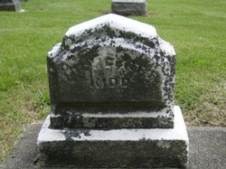
| Burial | : | Maryborough Cemetery, Maryborough, Fraser Coast Region, Australia |
| Coordinate | : | -25.5165460, 152.6735930 |
| Plot | : | Sec OP Lot 195, Space 4 |
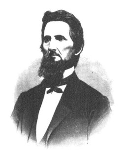
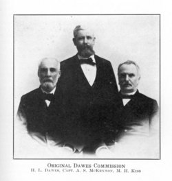
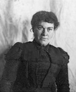
| Description | : | Daughter of Stearns Fisher (1804-1877) and Susan Ingersall (before 1816 - April 1843). After Haittie's mother died, Sterns married Harriet L. Loveland (1809 - aft. 1884) in 1845, who served as step-mother to his four young children. Harriet (Fisher) Kidd was the second wife of Meredith Helm Kidd (1829-1908), and sister of Millicent (Fisher) Kidd (1834-1881), the first wife of Meredith Helm Kidd. Meredith and Harriet were maried on 17 Oct 1883 in Eureka, Greenwood County, Kansas where Hattie had taught school and then established a book and stationery shop. They returned to Wabash, Indiana to reside and begin work... Read More |
frequently asked questions (FAQ):
-
Where is Harriet F. “Hattie” Fisher Kidd's memorial?
Harriet F. “Hattie” Fisher Kidd's memorial is located at: Maryborough Cemetery, Maryborough, Fraser Coast Region, Australia.
-
When did Harriet F. “Hattie” Fisher Kidd death?
Harriet F. “Hattie” Fisher Kidd death on 24 Mar 1923 in Wabash, Wabash County, Indiana, USA
-
Where are the coordinates of the Harriet F. “Hattie” Fisher Kidd's memorial?
Latitude: -25.5165460
Longitude: 152.6735930
Family Members:
Parent
Spouse
Siblings
Children
Flowers:


Nearby Cemetories:
1. Maryborough Cemetery
Maryborough, Fraser Coast Region, Australia
Coordinate: -25.5165460, 152.6735930
2. Maryborough Lawn Cemetery
Maryborough, Fraser Coast Region, Australia
Coordinate: -25.5126410, 152.6731850
3. Maryborough Crematorium
Maryborough, Fraser Coast Region, Australia
Coordinate: -25.5116294, 152.6716756
4. Maryborough Pioneer Cemetery
Maryborough, Fraser Coast Region, Australia
Coordinate: -25.5232830, 152.6746380
5. Elizabeth Park Rose Gardens
Maryborough, Fraser Coast Region, Australia
Coordinate: -25.5317100, 152.6952600
6. Commissioner Bidwill's Grave
Maryborough, Fraser Coast Region, Australia
Coordinate: -25.5631670, 152.7110000
7. Barlows Farm Cemetery
Takura, Fraser Coast Region, Australia
Coordinate: -25.3330030, 152.7191200
8. Tiaro Cemetery
Tiaro, Fraser Coast Region, Australia
Coordinate: -25.7173650, 152.5856850
9. Aalborg Danish Cemetery
Nikenbah, Fraser Coast Region, Australia
Coordinate: -25.3169800, 152.8047240
10. Bayside Gardens Crematorium
Nikenbah, Fraser Coast Region, Australia
Coordinate: -25.3135540, 152.8020030
11. Howard Remembrance Park
Howard, Fraser Coast Region, Australia
Coordinate: -25.3054360, 152.5470520
12. Hervey Bay Crematorium
Hervey Bay, Fraser Coast Region, Australia
Coordinate: -25.2991870, 152.8075780
13. Polson Cemetery
Point Vernon, Fraser Coast Region, Australia
Coordinate: -25.2522717, 152.8135186
14. Deborah Cemetery
Netherby, Fraser Coast Region, Australia
Coordinate: -25.7827119, 152.4940048
15. Big Woody Island Cemetery
Hervey Bay, Fraser Coast Region, Australia
Coordinate: -25.2828650, 152.9544730
16. St Mary's Anglican Churchyard
Brooweena, Fraser Coast Region, Australia
Coordinate: -25.6155810, 152.2342900
17. Munna Creek Cemetery
Gundiah, Fraser Coast Region, Australia
Coordinate: -25.8943010, 152.4806150
18. Agnes Vale Station Cemetery
Childers, Bundaberg Region, Australia
Coordinate: -25.2720660, 152.2496070
19. Childers Lawn Cemetery
Childers, Bundaberg Region, Australia
Coordinate: -25.2241618, 152.2642764
20. Dickabram Cemetery
Miva, Gympie Region, Australia
Coordinate: -25.9604510, 152.4848260
21. Gunalda Cemetery
Gunalda, Gympie Region, Australia
Coordinate: -25.9877920, 152.5557680
22. Tozer Park Cemetery (Defunct)
Gympie, Gympie Region, Australia
Coordinate: -26.0008330, 152.7438890
23. Neerdie Cemetery
Gympie, Gympie Region, Australia
Coordinate: -26.0008540, 152.7442570
24. Apple Tree Creek Cemetery
Apple Tree Creek, Bundaberg Region, Australia
Coordinate: -25.2254030, 152.2386650