
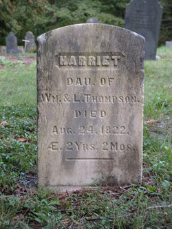
Harriet Thompson
| Birth | : | 24 Jun 1820 USA |
| Death | : | 24 Aug 1822 Heath, Franklin County, Massachusetts, USA |
| Burial | : | Pleasant Hill Cemetery, Meno, Major County, USA |
| Coordinate | : | 36.3916800, -98.2027300 |
| Plot | : | Thompson Plot |
| Inscription | : | Harriet dau W & L died 24 Aug 1822 ae 2 yrs 2 mos |
| Description | : | DOB calculated from DOD. Harriet daughter of William & Levina Thompson. Died aged 2 yrs 2 mos. |
frequently asked questions (FAQ):
-
Where is Harriet Thompson's memorial?
Harriet Thompson's memorial is located at: Pleasant Hill Cemetery, Meno, Major County, USA.
-
When did Harriet Thompson death?
Harriet Thompson death on 24 Aug 1822 in Heath, Franklin County, Massachusetts, USA
-
Where are the coordinates of the Harriet Thompson's memorial?
Latitude: 36.3916800
Longitude: -98.2027300
Family Members:
Parent
Siblings
Flowers:


Nearby Cemetories:
1. Pleasant Hill Cemetery
Meno, Major County, USA
Coordinate: 36.3916800, -98.2027300
2. New Hopedale Mennonite Memorial Cemetery
Meno, Major County, USA
Coordinate: 36.3932600, -98.1756500
3. Era Cemetery
Meno, Major County, USA
Coordinate: 36.3478400, -98.2113300
4. Union Cemetery
Meno, Major County, USA
Coordinate: 36.4452400, -98.1756100
5. West New Hopedale Cemetery
Ringwood, Major County, USA
Coordinate: 36.4484700, -98.2482400
6. Free Home Cemetery
Ringwood, Major County, USA
Coordinate: 36.4049988, -98.2897034
7. Concord Cemetery
Meno, Major County, USA
Coordinate: 36.3250008, -98.1572037
8. Glenwood Cemetery
Ringwood, Major County, USA
Coordinate: 36.3177986, -98.2472000
9. Oakdale Cemetery
Hoopsville, Major County, USA
Coordinate: 36.3474620, -98.3011040
10. Zion Lutheran Cemetery
Lahoma, Garfield County, USA
Coordinate: 36.4258600, -98.0873000
11. Lahoma Mennonite Cemetery
Lahoma, Garfield County, USA
Coordinate: 36.4256400, -98.0864800
12. Saint Michael Cemetery
Goltry, Alfalfa County, USA
Coordinate: 36.4785995, -98.1399994
13. Baumagartner Cemetery
Lahoma, Garfield County, USA
Coordinate: 36.4194700, -98.0779100
14. Boyer Family Cemetery
Goltry, Alfalfa County, USA
Coordinate: 36.5033440, -98.1758660
15. Forrest Cemetery
Ringwood, Major County, USA
Coordinate: 36.3764000, -98.3455963
16. Sorge Cemetery
Major County, USA
Coordinate: 36.3046989, -98.3003006
17. Good Hope Cemetery
Helena, Alfalfa County, USA
Coordinate: 36.5078011, -98.2481003
18. Sunnyside Cemetery
Lahoma, Garfield County, USA
Coordinate: 36.3692017, -98.0500031
19. Ames Cemetery
Ames, Major County, USA
Coordinate: 36.2675018, -98.1761017
20. Rupert Cemetery
Helena, Alfalfa County, USA
Coordinate: 36.5069008, -98.2981033
21. Trinity Lutheran Cemetery
Enid, Garfield County, USA
Coordinate: 36.4195300, -98.0342500
22. Square Cedar Cemetery
Cleo Springs, Major County, USA
Coordinate: 36.4413986, -98.3713989
23. Karoma Cemetery
Goltry, Alfalfa County, USA
Coordinate: 36.5278015, -98.1389008
24. Rose Hill Cemetery
Carrier, Garfield County, USA
Coordinate: 36.4782753, -98.0322952