
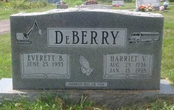
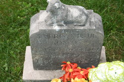
Harriet V Beckman DeBerry
| Birth | : | 28 Aug 1936 Garrett County, Maryland, USA |
| Death | : | 13 Jan 1998 Deer Park, Garrett County, Maryland, USA |
| Burial | : | Stanwood Cemetery, Stanwood, Mecosta County, USA |
| Coordinate | : | 43.5769691, -85.4444885 |
| Description | : | HARRIET V DEBERRY DEER PARK - Harriet V. DeBerry, 61, of 2534 Boiling Springs Road, Deer Park, died Tuesday, Jan. 13, 1998, at her home. Born Aug. 28, 1936, in Garrett County, she was a daughter of Rachel (Schmidt) Beckman, of Deer Park, and the late Walter N. Beckman. Mrs. DeBerry was a school bus contractor for the Garrett County Board of Education for 17 years. She was a member of the Deer Park Homemakers Club; the Deer Park Civic Group; the Garrett County Farm Bureau; and the Farmers Home Advisory Commission, and was a former 4H leader. She was a member of... Read More |
frequently asked questions (FAQ):
-
Where is Harriet V Beckman DeBerry's memorial?
Harriet V Beckman DeBerry's memorial is located at: Stanwood Cemetery, Stanwood, Mecosta County, USA.
-
When did Harriet V Beckman DeBerry death?
Harriet V Beckman DeBerry death on 13 Jan 1998 in Deer Park, Garrett County, Maryland, USA
-
Where are the coordinates of the Harriet V Beckman DeBerry's memorial?
Latitude: 43.5769691
Longitude: -85.4444885
Family Members:
Parent

Siblings

Children
Flowers:


Nearby Cemetories:
1. Stanwood Cemetery
Stanwood, Mecosta County, USA
Coordinate: 43.5769691, -85.4444885
2. Mecosta County Farm Cemetery
Mecosta Township, Mecosta County, USA
Coordinate: 43.5738200, -85.4447300
3. Quigley Cemetery
Deerfield Township, Mecosta County, USA
Coordinate: 43.5536003, -85.3930969
4. Zions Cemetery
Mecosta Township, Mecosta County, USA
Coordinate: 43.5696983, -85.5100021
5. Higbee Cemetery
Stanwood, Mecosta County, USA
Coordinate: 43.5394707, -85.3921890
6. Olin Cemetery
Stanwood, Mecosta County, USA
Coordinate: 43.5879000, -85.3719500
7. Ladner Cemetery
Stanwood, Mecosta County, USA
Coordinate: 43.6206017, -85.4918976
8. Holt Cemetery
Morley, Mecosta County, USA
Coordinate: 43.5130997, -85.4332962
9. Fairview Cemetery
Mecosta Township, Mecosta County, USA
Coordinate: 43.5891991, -85.5335999
10. Saint Apollonia Cemetery
Morley, Mecosta County, USA
Coordinate: 43.4907990, -85.4278030
11. Aetna Township Cemetery
Morley, Mecosta County, USA
Coordinate: 43.4906006, -85.4597015
12. Pine Plains Cemetery
Big Rapids, Mecosta County, USA
Coordinate: 43.6680984, -85.4436035
13. West Aetna Cemetery
Aetna Township, Mecosta County, USA
Coordinate: 43.5367660, -85.5623060
14. Boyd Cemetery
Morley, Mecosta County, USA
Coordinate: 43.4796982, -85.3818970
15. Rustford Cemetery
Morley, Mecosta County, USA
Coordinate: 43.4972916, -85.3432999
16. Altona Cemetery
Altona, Mecosta County, USA
Coordinate: 43.5393982, -85.3003006
17. Saint Andrews Episcopal Church Columbarium
Big Rapids, Mecosta County, USA
Coordinate: 43.6946130, -85.4835020
18. Rodney Cemetery
Rodney, Mecosta County, USA
Coordinate: 43.6703491, -85.3264923
19. Highland View Cemetery
Big Rapids, Mecosta County, USA
Coordinate: 43.7032318, -85.4905319
20. Goodwell Cemetery
Goodwell Township, Newaygo County, USA
Coordinate: 43.5992012, -85.6235962
21. Hinton Cemetery
Hinton Township, Mecosta County, USA
Coordinate: 43.5219002, -85.2643967
22. Amble Cemetery
Amble, Montcalm County, USA
Coordinate: 43.4352989, -85.4024963
23. Martiny Township Cemetery
Martiny Township, Mecosta County, USA
Coordinate: 43.6852989, -85.3097000
24. Mount Carmel Cemetery
Big Rapids, Mecosta County, USA
Coordinate: 43.7146187, -85.5154572