
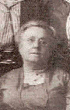
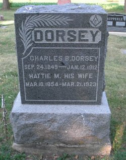
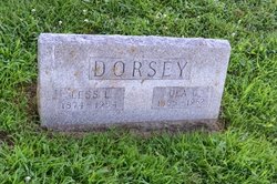
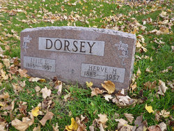
Harriett M. “Hattie” Smith Dorsey
| Birth | : | 10 Mar 1854 |
| Death | : | 21 Mar 1923 |
| Burial | : | Odebolt Cemetery, Odebolt, Sac County, USA |
| Coordinate | : | 42.2985992, -95.2469025 |
| Plot | : | Bk 14 Lot 6 |
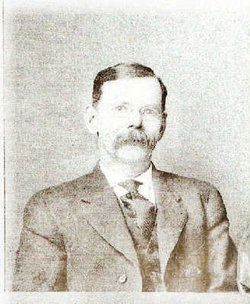
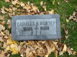
| Description | : | MRS. HATTIE DORSEY Mrs Hattie Dorsey was born in Johnson County, Iowa, March 10, 1854, and passed away at the home of her daughter, Mrs Ray Vinal at Davenport, Iowa, on March 21st, 1923 at the age of sixty nine years and eleven days. In 1872, at the age of eighteen years Hattie Smith was united in marriage Charles B, Dorsey, at Iowa City, and God blessed this union with sixteen children, all of whom are living except three. In the spring of 1878 they moved from Johnson County to Adair County, locating on a farm near Greenfield,... Read More |
frequently asked questions (FAQ):
-
Where is Harriett M. “Hattie” Smith Dorsey's memorial?
Harriett M. “Hattie” Smith Dorsey's memorial is located at: Odebolt Cemetery, Odebolt, Sac County, USA.
-
When did Harriett M. “Hattie” Smith Dorsey death?
Harriett M. “Hattie” Smith Dorsey death on 21 Mar 1923 in
-
Where are the coordinates of the Harriett M. “Hattie” Smith Dorsey's memorial?
Latitude: 42.2985992
Longitude: -95.2469025
Family Members:
Parent
Spouse
Siblings
Children
Flowers:


Nearby Cemetories:
1. Odebolt Cemetery
Odebolt, Sac County, USA
Coordinate: 42.2985992, -95.2469025
2. Saint Martins Catholic Cemetery
Odebolt, Sac County, USA
Coordinate: 42.2985573, -95.2481842
3. Richland Cemetery
Sac County, USA
Coordinate: 42.3544006, -95.2238998
4. Hayes Township Cemetery
Arthur, Ida County, USA
Coordinate: 42.2943993, -95.3427963
5. Salem Reform Cemetery
Sac County, USA
Coordinate: 42.3555984, -95.1866989
6. Tom Marks Cemetery
Wall Lake, Sac County, USA
Coordinate: 42.2537000, -95.1605000
7. Clinton Township Cemetery
Sac County, USA
Coordinate: 42.3330600, -95.1475000
8. Linton Cemetery
Sac County, USA
Coordinate: 42.3330994, -95.1474991
9. Bethel Cemetery
Kiron, Crawford County, USA
Coordinate: 42.2192001, -95.3043976
10. Emmanuel Cemetery
Cook Township, Sac County, USA
Coordinate: 42.3993988, -95.2063980
11. Saint John Lutheran Church Cemetery
Crawford County, USA
Coordinate: 42.1780000, -95.2650000
12. Wall Lake Cemetery
Wall Lake, Sac County, USA
Coordinate: 42.2757988, -95.0805969
13. Kiron Cemetery
Kiron, Crawford County, USA
Coordinate: 42.1817017, -95.3133011
14. Hayes Chapel Cemetery
Ida Grove, Ida County, USA
Coordinate: 42.2723897, -95.4215386
15. South Wall Lake Cemetery
Wall Lake, Sac County, USA
Coordinate: 42.2318993, -95.0911026
16. Cook Center Cemetery
Schaller, Sac County, USA
Coordinate: 42.4432983, -95.2649994
17. Protestant Union Cemetery
Early, Sac County, USA
Coordinate: 42.4294014, -95.1483002
18. Ida Grove Cemetery
Ida Grove, Ida County, USA
Coordinate: 42.3560982, -95.4516983
19. Sac County Farm Cemetery
Early, Sac County, USA
Coordinate: 42.4295560, -95.1175190
20. Grant Township Cemetery
Ida Grove, Ida County, USA
Coordinate: 42.2242012, -95.4569016
21. Ferguson Cemetery
Lake View, Sac County, USA
Coordinate: 42.3142014, -95.0132980
22. Immanuel Presbyterian Cemetery
Carnarvon, Sac County, USA
Coordinate: 42.2392006, -95.0224991
23. Early Union Cemetery
Early, Sac County, USA
Coordinate: 42.4578018, -95.1425018
24. Lehfeldt Cemetery
Kiron, Crawford County, USA
Coordinate: 42.1458170, -95.3724972