
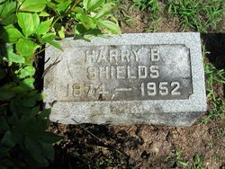
Harry B. Shields
| Birth | : | 1874 |
| Death | : | 25 Feb 1952 Marshall, Clark County, Illinois, USA |
| Burial | : | All Saints' Churchyard, Saxby-All-Saints, North Lincolnshire Unitary Authority, England |
| Coordinate | : | 53.6372500, -0.5010260 |
| Description | : | The Daily Clintonian Monday, February 25, 1952 Harry B. Shields, 77, of 1122 South 18th Street, Terre Haute, died at the Dunkel Nursing Home in Marshall, IL, at 1:00 today after a three months illness. He is survived by the widow Mabel Mack; 2 nieces, Mrs. Lillian Johnson and Mrs. Bertha Shields, both of Terre Haute; and 2 nephews, John Shields of Akron, OH, and Harold Mack of Clinton. The body was taken to the Frist Funeral Home and will be taken to the Montrose Methodist Church in Terre Haute at noon Tuesday and will remain at the church for services at 3:00 p.m.... Read More |
frequently asked questions (FAQ):
-
Where is Harry B. Shields's memorial?
Harry B. Shields's memorial is located at: All Saints' Churchyard, Saxby-All-Saints, North Lincolnshire Unitary Authority, England.
-
When did Harry B. Shields death?
Harry B. Shields death on 25 Feb 1952 in Marshall, Clark County, Illinois, USA
-
Where are the coordinates of the Harry B. Shields's memorial?
Latitude: 53.6372500
Longitude: -0.5010260
Family Members:
Spouse
Flowers:


Nearby Cemetories:
1. All Saints' Churchyard
Saxby-All-Saints, North Lincolnshire Unitary Authority, England
Coordinate: 53.6372500, -0.5010260
2. St Maurice Churchyard
Horkstow, North Lincolnshire Unitary Authority, England
Coordinate: 53.6512040, -0.5079660
3. St Andrew Churchyard
Bonby, North Lincolnshire Unitary Authority, England
Coordinate: 53.6266000, -0.4838000
4. St. Clement's Churchyard
Worlaby, North Lincolnshire Unitary Authority, England
Coordinate: 53.6129220, -0.4667760
5. St Nicholas Churchyard
South Ferriby, North Lincolnshire Unitary Authority, England
Coordinate: 53.6746420, -0.5051450
6. St Bartholomew's Church
Appleby, North Lincolnshire Unitary Authority, England
Coordinate: 53.6234280, -0.5603240
7. Winterton Cemetery
Winterton, North Lincolnshire Unitary Authority, England
Coordinate: 53.6548190, -0.5847270
8. All Saints Church
Elsham, North Lincolnshire Unitary Authority, England
Coordinate: 53.5992620, -0.4355590
9. Elwes Private Cemetery, Elsham Hall
Elsham, North Lincolnshire Unitary Authority, England
Coordinate: 53.5932154, -0.4451006
10. All Saints Churchyard
Winterton, North Lincolnshire Unitary Authority, England
Coordinate: 53.6555710, -0.5968640
11. St Mary's Churchyard
Barton-upon-Humber, North Lincolnshire Unitary Authority, England
Coordinate: 53.6844300, -0.4367800
12. Barton-upon-Humber Old Cemetery
Barton-upon-Humber, North Lincolnshire Unitary Authority, England
Coordinate: 53.6818650, -0.4284450
13. Barton-Upon-Humber Cemetery
Barton-upon-Humber, North Lincolnshire Unitary Authority, England
Coordinate: 53.6817370, -0.4279560
14. Broughton Cemetery
Broughton, North Lincolnshire Unitary Authority, England
Coordinate: 53.5732500, -0.5582900
15. Saint Mary's Church
Wrawby, North Lincolnshire Unitary Authority, England
Coordinate: 53.5642110, -0.4609630
16. St Marys Churchyard
Broughton, North Lincolnshire Unitary Authority, England
Coordinate: 53.5654330, -0.5514190
17. Broughton Church Cemetery
Broughton, North Lincolnshire Unitary Authority, England
Coordinate: 53.5649200, -0.5504110
18. All Saints Churchyard
Winteringham, North Lincolnshire Unitary Authority, England
Coordinate: 53.6902800, -0.6010700
19. All Saints Churchyard
Winteringham, North Lincolnshire Unitary Authority, England
Coordinate: 53.6904182, -0.6010190
20. Barrow-Upon-Humber Cemetery
Barrow upon Humber, North Lincolnshire Unitary Authority, England
Coordinate: 53.6678740, -0.3755040
21. St. Mary's Churchyard
Barnetby le Wold, North Lincolnshire Unitary Authority, England
Coordinate: 53.5782540, -0.4088070
22. Brigg Cemetery
Brigg, North Lincolnshire Unitary Authority, England
Coordinate: 53.5559600, -0.4817300
23. Holy Trinity Churchyard
Barrow upon Humber, North Lincolnshire Unitary Authority, England
Coordinate: 53.6783720, -0.3787880
24. St John the Evangelist Churchyard
Brigg, North Lincolnshire Unitary Authority, England
Coordinate: 53.5518740, -0.4913750