
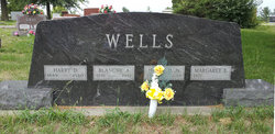
Harry Duncan Wells Sr.
| Birth | : | 15 Sep 1889 Skidmore, Nodaway County, Missouri, USA |
| Death | : | 18 Mar 1980 Maryville, Nodaway County, Missouri, USA |
| Burial | : | Mountain Meadow Cemetery, Lawrence County, USA |
| Coordinate | : | 44.2038994, -103.6557999 |
| Plot | : | Sec 1, Row 5 S-N |
frequently asked questions (FAQ):
-
Where is Harry Duncan Wells Sr.'s memorial?
Harry Duncan Wells Sr.'s memorial is located at: Mountain Meadow Cemetery, Lawrence County, USA.
-
When did Harry Duncan Wells Sr. death?
Harry Duncan Wells Sr. death on 18 Mar 1980 in Maryville, Nodaway County, Missouri, USA
-
Where are the coordinates of the Harry Duncan Wells Sr.'s memorial?
Latitude: 44.2038994
Longitude: -103.6557999
Family Members:
Parent
Spouse

Siblings

Children

Flowers:


Nearby Cemetories:
1. Mountain Meadow Cemetery
Lawrence County, USA
Coordinate: 44.2038994, -103.6557999
2. Roubaix Cemetery
Roubaix, Lawrence County, USA
Coordinate: 44.2789380, -103.6656600
3. Dumont Cemetery
Lawrence County, USA
Coordinate: 44.2270000, -103.7860000
4. Nemo Cemetery
Nemo, Lawrence County, USA
Coordinate: 44.1872800, -103.5066410
5. Bell Park Cemetery
Rochford, Pennington County, USA
Coordinate: 44.1116982, -103.7466965
6. Galena Cemetery
Galena, Lawrence County, USA
Coordinate: 44.3349220, -103.6438410
7. Holy Cross Cemetery
Englewood, Lawrence County, USA
Coordinate: 44.2818985, -103.8047028
8. Mountain Lawn Cemetery
Englewood, Lawrence County, USA
Coordinate: 44.2818985, -103.8047028
9. Carr Cemetery
Hanna, Lawrence County, USA
Coordinate: 44.2411003, -103.8606033
10. Reynolds Ranch Cemetery
Rochford, Pennington County, USA
Coordinate: 44.0875667, -103.8027265
11. South Lead Cemetery
Lead, Lawrence County, USA
Coordinate: 44.3478510, -103.7606260
12. West Lead Cemetery
Lead, Lawrence County, USA
Coordinate: 44.3484001, -103.7779999
13. Terry Cemetery
Terry, Lawrence County, USA
Coordinate: 44.3344290, -103.8165110
14. Mount Moriah Cemetery
Deadwood, Lawrence County, USA
Coordinate: 44.3760986, -103.7253036
15. Saint Ambrose Cemetery
Deadwood, Lawrence County, USA
Coordinate: 44.3821983, -103.7266998
16. Oak Ridge Cemetery
Deadwood, Lawrence County, USA
Coordinate: 44.3891983, -103.6766968
17. Piedmont Cemetery
Piedmont, Meade County, USA
Coordinate: 44.2425780, -103.3871730
18. Black Hills National Cemetery
Sturgis, Meade County, USA
Coordinate: 44.3689003, -103.4753036
19. Curley Grimes Memorial Cemetery
Sturgis, Meade County, USA
Coordinate: 44.3764500, -103.4691300
20. Preston Ghost Town Cemetery
Preston, Lawrence County, USA
Coordinate: 44.3577500, -103.8871670
21. Saint Aloysius Cemetery
Sturgis, Meade County, USA
Coordinate: 44.4141340, -103.5193420
22. Fort Meade National Cemetery
Sturgis, Meade County, USA
Coordinate: 44.4021988, -103.4757996
23. Bear Butte Cemetery
Sturgis, Meade County, USA
Coordinate: 44.4111595, -103.4947968
24. Crook City Cemetery
Crook City, Lawrence County, USA
Coordinate: 44.4432100, -103.6241500