
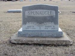
Harry Harvey Spunaugle
| Birth | : | 23 Aug 1891 Howard, Elk County, Kansas, USA |
| Death | : | 8 Mar 1949 El Dorado, Butler County, Kansas, USA |
| Burial | : | Griffith Cemetery, Griffith, Griffith City, Australia |
| Coordinate | : | -34.2860690, 146.0670780 |
| Plot | : | Section 16, Space 24 |
| Description | : | On stone with wife May R. Spunaugle |
frequently asked questions (FAQ):
-
Where is Harry Harvey Spunaugle's memorial?
Harry Harvey Spunaugle's memorial is located at: Griffith Cemetery, Griffith, Griffith City, Australia.
-
When did Harry Harvey Spunaugle death?
Harry Harvey Spunaugle death on 8 Mar 1949 in El Dorado, Butler County, Kansas, USA
-
Where are the coordinates of the Harry Harvey Spunaugle's memorial?
Latitude: -34.2860690
Longitude: 146.0670780
Family Members:
Parent

Spouse

Siblings
Children
Flowers:


Nearby Cemetories:
1. Griffith Cemetery
Griffith, Griffith City, Australia
Coordinate: -34.2860690, 146.0670780
2. Bagtown Cemetery
Hanwood, Griffith City, Australia
Coordinate: -34.3157900, 146.0471780
3. Yenda Cemetery
Yenda, Griffith City, Australia
Coordinate: -34.2395859, 146.2337537
4. Binya Cemetery
Binya, Narrandera Shire, Australia
Coordinate: -34.2062610, 146.3046460
5. Whitton Cemetery
Whitton, Leeton Shire, Australia
Coordinate: -34.4964100, 146.1814000
6. Sandy Valley Station Cemetery
Tabbita, Carrathool Shire, Australia
Coordinate: -34.1295560, 145.8606970
7. Darlington Point Cemetery
Darlington Point, Murrumbidgee Council, Australia
Coordinate: -34.5728920, 145.9977010
8. Warangesda Cemetery
Darlington Point, Murrumbidgee Council, Australia
Coordinate: -34.5860710, 146.0041480
9. Benerembah Run Cemetery
Carrathool Shire, Australia
Coordinate: -34.5620060, 145.8464370
10. Leeton Cemetery
Leeton, Leeton Shire, Australia
Coordinate: -34.5320150, 146.3980150
11. Wyvern Station Cemetery
Carrathool Shire, Australia
Coordinate: -34.4631410, 145.6608490
12. Goolgowi Cemetery
Goolgowi, Carrathool Shire, Australia
Coordinate: -33.9874263, 145.6984768
13. Barellan General Cemetery
Barellan, Narrandera Shire, Australia
Coordinate: -34.3146610, 146.5908060
14. Groongal Station
Carrathool, Carrathool Shire, Australia
Coordinate: -34.4397590, 145.5605470
15. Colinroobie (Bents Hill) Cemetery
Colinroobie, Narrandera Shire, Australia
Coordinate: -34.4445150, 146.6028400
16. Rankins Springs Cemetery
Rankins Springs, Carrathool Shire, Australia
Coordinate: -33.8255770, 146.2911550
17. Carrathool Cemetery
Carrathool, Carrathool Shire, Australia
Coordinate: -34.4451390, 145.4769990
18. Rudds Point Station Cemetery
Carrathool Shire, Australia
Coordinate: -34.4682990, 145.4476200
19. Coleambally Cemetery
Coleambally, Murrumbidgee Council, Australia
Coordinate: -34.8132800, 145.8762100
20. Howlong Station Cemetery
Carrathool Shire, Australia
Coordinate: -34.4527050, 145.3780160
21. Weethalle Cemetery
Weethalle, Bland Shire, Australia
Coordinate: -33.8852100, 146.6065050
22. Narrandera Cemetery
Narrandera, Narrandera Shire, Australia
Coordinate: -34.7412950, 146.5423820
23. Merriwagga Cemetery
Merriwagga, Carrathool Shire, Australia
Coordinate: -33.8210900, 145.6078400
24. Gunbar Cemetery
Gunbar, Carrathool Shire, Australia
Coordinate: -34.0145240, 145.4078880