
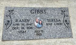
Harry Randall “Randy” Gibbs
| Birth | : | 19 Apr 1947 Oklahoma City, Oklahoma County, Oklahoma, USA |
| Death | : | 24 Oct 2016 Santa Maria, Santa Barbara County, California, USA |
| Burial | : | Santa Maria Cemetery District, Santa Maria, Santa Barbara County, USA |
| Coordinate | : | 34.9369011, -120.4253006 |
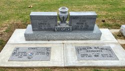
| Description | : | Randy Gibbs, a long-time resident of Santa Maria, passed away peacefully after a lengthy illness, surrounding by his loving family Monday, Oct 24. He was born April 19, l947, in Oklahoma City, OK. to the late Harry W. Gibbs and Margaret G. Shroyer. He was raised by his mother and Max Logan, his step-father, on a dairy farm in Iowa. He married the love of his life, Teresa Viegas, in 1969 in Santa Maria. They met while Randy was in the U.S. Air Force stationed at Vandenberg. After their marriage, they lived in Puerto Rico for two years. After Randy served... Read More |
frequently asked questions (FAQ):
-
Where is Harry Randall “Randy” Gibbs's memorial?
Harry Randall “Randy” Gibbs's memorial is located at: Santa Maria Cemetery District, Santa Maria, Santa Barbara County, USA.
-
When did Harry Randall “Randy” Gibbs death?
Harry Randall “Randy” Gibbs death on 24 Oct 2016 in Santa Maria, Santa Barbara County, California, USA
-
Where are the coordinates of the Harry Randall “Randy” Gibbs's memorial?
Latitude: 34.9369011
Longitude: -120.4253006
Family Members:
Parent

Flowers:


Nearby Cemetories:
1. Santa Maria Cemetery District
Santa Maria, Santa Barbara County, USA
Coordinate: 34.9369011, -120.4253006
2. Dudley-Hoffman Memory Gardens Columbarium
Santa Maria, Santa Barbara County, USA
Coordinate: 34.9388480, -120.4215260
3. Bethel Lutheran Church Resurrection Garden
Santa Maria, Santa Barbara County, USA
Coordinate: 34.9415700, -120.4279900
4. Pine Grove Cemetery
Santa Barbara County, USA
Coordinate: 34.8550430, -120.4185950
5. Guadalupe Cemetery
Guadalupe, Santa Barbara County, USA
Coordinate: 34.9582863, -120.5741501
6. Our Lady of Guadalupe Catholic Cemetery
Guadalupe, Santa Barbara County, USA
Coordinate: 34.9284800, -120.5911300
7. Saint Joseph of Cupertino Province Cemetery
San Luis Obispo County, USA
Coordinate: 35.0718803, -120.5263519
8. Ontiveros Cemetery
Los Alamos, Santa Barbara County, USA
Coordinate: 34.8897000, -120.2334900
9. San Ramon Chapel Cemetery
Santa Barbara County, USA
Coordinate: 34.8478012, -120.2394028
10. Guillermo Eduardo de la Guerra Burial Site
Los Alamos, Santa Barbara County, USA
Coordinate: 34.7500000, -120.3500000
11. Saint John's Lutheran Church Columbarium
Arroyo Grande, San Luis Obispo County, USA
Coordinate: 35.1032070, -120.5808630
12. Saint Barnabas Memorial Garden
Arroyo Grande, San Luis Obispo County, USA
Coordinate: 35.1179910, -120.5706380
13. Halcyon Cemetery
Halcyon, San Luis Obispo County, USA
Coordinate: 35.1062000, -120.5994990
14. Arroyo Grande Cemetery
Arroyo Grande, San Luis Obispo County, USA
Coordinate: 35.1230011, -120.5930634
15. Los Alamos Cemetery
Los Alamos, Santa Barbara County, USA
Coordinate: 34.7327995, -120.2807999
16. Saint Patrick's Cemetery
Arroyo Grande, San Luis Obispo County, USA
Coordinate: 35.1292740, -120.6002950
17. Saint Mary's Episcopal Memory Garden
Lompoc, Santa Barbara County, USA
Coordinate: 34.6807100, -120.4533500
18. Mission La Purisima Concepcion Cemetery
Lompoc, Santa Barbara County, USA
Coordinate: 34.6716652, -120.4216690
19. Lompoc Evergreen Cemetery
Lompoc, Santa Barbara County, USA
Coordinate: 34.6296997, -120.4477997
20. Saint Mark's-in-the-Valley Church Mem. Garden
Los Olivos, Santa Barbara County, USA
Coordinate: 34.6662590, -120.1177210
21. Carroll-McGovern Cemetery
Pozo, San Luis Obispo County, USA
Coordinate: 35.3069100, -120.3598100
22. San Luis Cemetery
San Luis Obispo, San Luis Obispo County, USA
Coordinate: 35.2644192, -120.6712830
23. Old Mission Cemetery
San Luis Obispo, San Luis Obispo County, USA
Coordinate: 35.2670660, -120.6692150
24. Mission San Luis Obispo Cemetery
San Luis Obispo, San Luis Obispo County, USA
Coordinate: 35.2806600, -120.6645200