

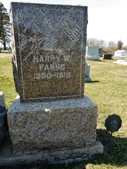
Harry W. Farno
| Birth | : | 4 Jan 1890 Stella, Richardson County, Nebraska, USA |
| Death | : | 15 Oct 1918 Fort Riley, Geary County, Kansas, USA |
| Burial | : | Pawnee City Cemetery, Pawnee City, Pawnee County, USA |
| Coordinate | : | 40.1109009, -96.1608810 |
| Plot | : | North 7-13-6 |
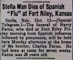
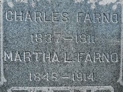
| Description | : | Son of Charles Farno & Martha Lucinda Coons Farno. WORLD WAR I (Pawnee Library, book of obits in the Pawnee Republican.) Suggested edit: Harry Farno died during the influenza pandemic. According to the Pawnee Republican, he had grown up in Pawnee City but after his father died when he was 17, he and his mother moved to the Stella area. He was remembered as a "thoughtful turn of mind. He was a great reader. It was only in intimate conversation with him that one discovered the great depth of his knowledge." Contributor: Sharla Cerra (48422291) • |
frequently asked questions (FAQ):
-
Where is Harry W. Farno's memorial?
Harry W. Farno's memorial is located at: Pawnee City Cemetery, Pawnee City, Pawnee County, USA.
-
When did Harry W. Farno death?
Harry W. Farno death on 15 Oct 1918 in Fort Riley, Geary County, Kansas, USA
-
Where are the coordinates of the Harry W. Farno's memorial?
Latitude: 40.1109009
Longitude: -96.1608810
Family Members:
Parent

Siblings

Flowers:


Nearby Cemetories:
1. Pawnee City Cemetery
Pawnee City, Pawnee County, USA
Coordinate: 40.1109009, -96.1608810
2. East Amish Cemetery
Table Rock, Pawnee County, USA
Coordinate: 40.1310000, -96.0854000
3. Evergreen Cemetery
Pawnee County, USA
Coordinate: 40.0485992, -96.1417007
4. Pleasant Valley Cemetery
Pawnee County, USA
Coordinate: 40.0299988, -96.1554794
5. Table Rock Cemetery
Table Rock, Pawnee County, USA
Coordinate: 40.1791400, -96.1037400
6. Prairie Star Pioneer Cemetery
Du Bois, Pawnee County, USA
Coordinate: 40.0293000, -96.1041000
7. Beranek Cemetery
Table Rock, Pawnee County, USA
Coordinate: 40.2042007, -96.1607971
8. Pleasant Ridge Cemetery
Du Bois, Pawnee County, USA
Coordinate: 40.0156000, -96.1494000
9. West Branch Cemetery
Pawnee County, USA
Coordinate: 40.0787940, -96.2797160
10. Saint Anthonys Cemetery
Steinauer, Pawnee County, USA
Coordinate: 40.2075005, -96.2189026
11. Johnson Creek Cemetery
Pawnee City, Pawnee County, USA
Coordinate: 40.0270000, -96.2465000
12. Clear Creek Cemetery
Table Rock, Pawnee County, USA
Coordinate: 40.2193985, -96.1391983
13. Bohemian Cemetery
Table Rock, Pawnee County, USA
Coordinate: 40.1786003, -96.0374985
14. Saint Peters Evangelican Cemetery
Du Bois, Pawnee County, USA
Coordinate: 40.0010000, -96.1095000
15. Dry Branch Pioneer Cemetery
Richardson County, USA
Coordinate: 40.1292000, -96.0100021
16. DuBois Cemetery
Du Bois, Pawnee County, USA
Coordinate: 40.0231018, -96.0488968
17. Bohemian Cemetery
Richardson County, USA
Coordinate: 40.1175003, -95.9955978
18. Saint Johns Cemetery
Table Rock, Pawnee County, USA
Coordinate: 40.2148000, -96.0657000
19. Salems Cemetery
Steinauer, Pawnee County, USA
Coordinate: 40.2166000, -96.2555000
20. McCaffrey Cemetery
Nemaha County, USA
Coordinate: 39.9827100, -96.1474500
21. Madden Cemetery
Axtell, Marshall County, USA
Coordinate: 39.9866800, -96.2490300
22. Friedens United Church of Christ Cemetery
Bern, Nemaha County, USA
Coordinate: 39.9929008, -96.0529480
23. Saint Peters Lutheran Church Cemetery
Steinauer, Pawnee County, USA
Coordinate: 40.2555000, -96.1801000
24. Cincinnati Cemetery
Du Bois, Pawnee County, USA
Coordinate: 40.0042000, -96.0274963