
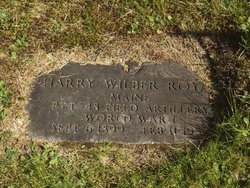
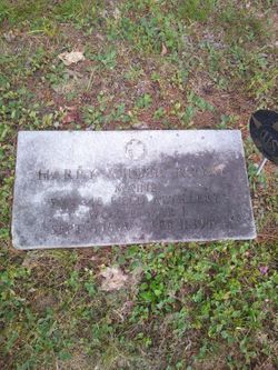
Harry Wilber Royal
| Birth | : | 6 Sep 1899 Lagrange, Penobscot County, Maine, USA |
| Death | : | 11 Feb 1957 |
| Burial | : | Friendship Methodist Cemetery, Monroeville, Salem County, USA |
| Coordinate | : | 39.6219101, -75.1827240 |
frequently asked questions (FAQ):
-
Where is Harry Wilber Royal's memorial?
Harry Wilber Royal's memorial is located at: Friendship Methodist Cemetery, Monroeville, Salem County, USA.
-
When did Harry Wilber Royal death?
Harry Wilber Royal death on 11 Feb 1957 in
-
Where are the coordinates of the Harry Wilber Royal's memorial?
Latitude: 39.6219101
Longitude: -75.1827240
Family Members:
Parent
Spouse
Children
Flowers:


Nearby Cemetories:
1. Friendship Methodist Cemetery
Monroeville, Salem County, USA
Coordinate: 39.6219101, -75.1827240
2. Chestnut Grove Cemetery
Elmer, Salem County, USA
Coordinate: 39.6049995, -75.1766968
3. Chickory Chapel Cemetery
Gloucester County, USA
Coordinate: 39.6244011, -75.1318970
4. Hardingville Cemetery
Hardingville, Gloucester County, USA
Coordinate: 39.6632100, -75.1790400
5. Pittsgrove Baptist Church Cemetery
Daretown, Salem County, USA
Coordinate: 39.6038208, -75.2559586
6. Gloucester County Veterans Memorial Cemetery
Williamstown, Gloucester County, USA
Coordinate: 39.6521279, -75.1163586
7. Aura Methodist Cemetery
Aura, Gloucester County, USA
Coordinate: 39.6725006, -75.1374969
8. Pittsgrove Presbyterian Church Cemetery
Daretown, Salem County, USA
Coordinate: 39.6009521, -75.2609253
9. Old Pittsgrove Presbyterian Church Cemetery
Daretown, Salem County, USA
Coordinate: 39.5998840, -75.2622986
10. Old Pittsgrove Baptist Churchyard
Upper Pittsgrove, Salem County, USA
Coordinate: 39.6119728, -75.2677689
11. Land Of Canaan Cemetery
Glassboro, Gloucester County, USA
Coordinate: 39.6741982, -75.1085968
12. Olivet Cemetery
Pittsgrove, Salem County, USA
Coordinate: 39.5430183, -75.1625671
13. Porchtown Zion Methodist Church Cemetery
Franklinville, Gloucester County, USA
Coordinate: 39.5895400, -75.0848000
14. Cedar Green Cemetery
Clayton, Gloucester County, USA
Coordinate: 39.6613998, -75.0852966
15. Aldine United Methodist Church Cemetery
Aldine, Salem County, USA
Coordinate: 39.5689125, -75.2749100
16. Centerton Free Will Baptist Cemetery
Centerton, Salem County, USA
Coordinate: 39.5335200, -75.1675300
17. Saint Johns United Methodist Church Cemetery
Harrisonville, Gloucester County, USA
Coordinate: 39.6842500, -75.2666000
18. Franklinville African Methodist Episcopal Cemetery
Gloucester County, USA
Coordinate: 39.6138500, -75.0666600
19. Ferrell United Methodist Church Cemetery
Harrisonville, Gloucester County, USA
Coordinate: 39.6847725, -75.2669296
20. Mount Laurel Church Cemetery
Yorketown, Salem County, USA
Coordinate: 39.6174020, -75.3023530
21. Trinity Bible Cemetery
Glassboro, Gloucester County, USA
Coordinate: 39.7003610, -75.1133800
22. Saint Bridgets Cemetery
Glassboro, Gloucester County, USA
Coordinate: 39.7023300, -75.1159000
23. Richwood United Methodist Church Cemetery
Richwood, Gloucester County, USA
Coordinate: 39.7211100, -75.1667700
24. Saint Thomas Episcopal Church Cemetery
Glassboro, Gloucester County, USA
Coordinate: 39.7079200, -75.1101500