
| Birth | : | 31 Dec 1890 Miller County, Missouri, USA |
| Death | : | 14 Nov 1959 Miller County, Missouri, USA |
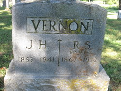
| Burial | : | Eldon Cemetery, Eldon, Miller County, USA |
| Coordinate | : | 38.3642006, -92.5868988 |
| Description | : | Jefferson City News and Tribune, Sunday, November 15, 1959, Jefferson City, Missouri Harvey Roy Vernon, 68-year-old retired Kansas City machinist, died Saturday at his home in Aurora Springs. He was born Dec. 31, 1890, in Miller County, the son of James and Rachael Cox Harvey. He married Miss Vica Simpson, Nov. 4, 1914. His wife survives him, along with two daughters, Mrs. Viola Cox, Toulan, Ill., and Mrs. Maxine Brizendine, Muncie, Kan.; five brothers, five sisters and five grandchildren. Funeral services are scheduled for 2 p.m. Tuesday at the Aurora Springs Baptist Church where Mr. Vernon was a member, the Rev. E.L. Dane... Read More |
frequently asked questions (FAQ):
-
Where is Harvey Roy Vernon's memorial?
Harvey Roy Vernon's memorial is located at: Eldon Cemetery, Eldon, Miller County, USA.
-
When did Harvey Roy Vernon death?
Harvey Roy Vernon death on 14 Nov 1959 in Miller County, Missouri, USA
-
Where are the coordinates of the Harvey Roy Vernon's memorial?
Latitude: 38.3642006
Longitude: -92.5868988
Family Members:
Parent

Spouse
Siblings


Children
Flowers:


Nearby Cemetories:
1. Salem Cemetery
Eldon, Miller County, USA
Coordinate: 38.3697014, -92.5714035
2. Salem Cemetery
Saline Township, Miller County, USA
Coordinate: 38.3691232, -92.5697260
3. Mount Vernon Cemetery
Eldon, Miller County, USA
Coordinate: 38.3624992, -92.5606003
4. Taylor Cemetery
Eldon, Miller County, USA
Coordinate: 38.3443985, -92.6303024
5. Hite Cemetery
Miller County, USA
Coordinate: 38.4039001, -92.5935974
6. Mount Pleasant Cemetery
Eldon, Miller County, USA
Coordinate: 38.3667700, -92.5300800
7. Green Ridge Baptist Church Cemetery
Eldon, Miller County, USA
Coordinate: 38.4116200, -92.5645700
8. Dooley Cemetery
Eldon, Miller County, USA
Coordinate: 38.3191400, -92.6353500
9. Olean Cemetery
Olean, Miller County, USA
Coordinate: 38.4131012, -92.5413971
10. Greenmore Memorial Gardens
Barnett, Morgan County, USA
Coordinate: 38.3787155, -92.6676254
11. White Cemetery
Miller County, USA
Coordinate: 38.3408012, -92.6647034
12. Colburn Cemetery
Eldon, Miller County, USA
Coordinate: 38.4246300, -92.6275500
13. Artz-Wenzel Cemetery
Eldon, Miller County, USA
Coordinate: 38.2980995, -92.5622025
14. Phillips Cemetery
Barnett, Morgan County, USA
Coordinate: 38.4227982, -92.6367035
15. Etter-Walker Cemetery
Burris Fork, Moniteau County, USA
Coordinate: 38.4333700, -92.5525400
16. Walker Cemetery
Moniteau County, USA
Coordinate: 38.4338989, -92.5522003
17. Phillips Cemetery
High Point, Moniteau County, USA
Coordinate: 38.4430300, -92.6125300
18. Farris Cemetery
Moniteau County, USA
Coordinate: 38.4369900, -92.5380000
19. Allen Cemetery
Olean, Miller County, USA
Coordinate: 38.4150009, -92.5008011
20. Skinner Cemetery
Miller County, USA
Coordinate: 38.2806015, -92.5481033
21. Jackson Chapel Methodist Church Cemetery
California, Moniteau County, USA
Coordinate: 38.4447900, -92.5286500
22. Gray Cemetery
Moniteau County, USA
Coordinate: 38.4536018, -92.5456009
23. Blue Springs Cemetery
Eldon, Miller County, USA
Coordinate: 38.2778015, -92.6603012
24. Kelsay Cemetery
Miller County, USA
Coordinate: 38.2663994, -92.5397034