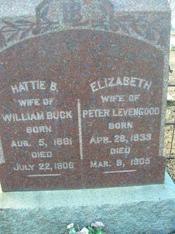
Hattie Bell Levengood Buck
| Birth | : | 5 Aug 1861 Memphis, Scotland County, Missouri, USA |
| Death | : | 22 Jul 1906 Anaconda, Deer Lodge County, Montana, USA |
| Burial | : | Saint Matthew's Episcopal Church Cemetery, Salisbury, Rowan County, USA |
| Coordinate | : | 35.7058983, -80.5554962 |
| Plot | : | Section H-Levengood section |
| Description | : | Married: William Buck 28 Dec. 1878 in Missouri |
frequently asked questions (FAQ):
-
Where is Hattie Bell Levengood Buck's memorial?
Hattie Bell Levengood Buck's memorial is located at: Saint Matthew's Episcopal Church Cemetery, Salisbury, Rowan County, USA.
-
When did Hattie Bell Levengood Buck death?
Hattie Bell Levengood Buck death on 22 Jul 1906 in Anaconda, Deer Lodge County, Montana, USA
-
Where are the coordinates of the Hattie Bell Levengood Buck's memorial?
Latitude: 35.7058983
Longitude: -80.5554962
Family Members:
Parent
Siblings
Flowers:
Nearby Cemetories:
1. Saint Matthew's Episcopal Church Cemetery
Salisbury, Rowan County, USA
Coordinate: 35.7058983, -80.5554962
2. Enon Baptist Church Cemetery
Salisbury, Rowan County, USA
Coordinate: 35.7082291, -80.5275421
3. Salem Lutheran Church Cemetery
Salisbury, Rowan County, USA
Coordinate: 35.6871986, -80.5721970
4. The Arbor United Methodist Church Cemetery
Salisbury, Rowan County, USA
Coordinate: 35.7356700, -80.5509200
5. Sherrills Ford Road Church Cemetery
Salisbury, Rowan County, USA
Coordinate: 35.6884308, -80.5954590
6. Gloria Dei Lutheran Church Columbarium
Salisbury, Rowan County, USA
Coordinate: 35.6938358, -80.5110054
7. Sacred Heart Roman Catholic Cemetery
Salisbury, Rowan County, USA
Coordinate: 35.7077500, -80.5074440
8. Franklin Presbyterian Church Cemetery
Franklin, Rowan County, USA
Coordinate: 35.7246880, -80.5032580
9. Second Creek AME Zion - New Birth of Christ Church
Franklin Township, Rowan County, USA
Coordinate: 35.7461100, -80.5252800
10. Rowan Memorial Park Cemetery
Salisbury, Rowan County, USA
Coordinate: 35.7178001, -80.4955978
11. Owen Family Cemetery
Salisbury, Rowan County, USA
Coordinate: 35.6652985, -80.5159988
12. Oakwood Cemetery
Salisbury, Rowan County, USA
Coordinate: 35.6789040, -80.4985750
13. Bethel Lutheran Church Cemetery
Franklin, Rowan County, USA
Coordinate: 35.7212500, -80.4909410
14. Salisbury National Cemetery Annex
Salisbury, Rowan County, USA
Coordinate: 35.6879710, -80.4912790
15. Saint Marks Lutheran Church Cemetery
Salisbury, Rowan County, USA
Coordinate: 35.6541670, -80.5822220
16. Second Creek AME Zion Cemetery
Franklin, Rowan County, USA
Coordinate: 35.7572189, -80.5209352
17. Owens Cemetery
Franklin, Rowan County, USA
Coordinate: 35.7581730, -80.5205010
18. Oakdale Union Hill Cemetery
Salisbury, Rowan County, USA
Coordinate: 35.6763130, -80.4905630
19. Cedar Grove AME Zion Church Cemetery
Rowan County, USA
Coordinate: 35.7240520, -80.6270450
20. Memorial Park Cemetery
Salisbury, Rowan County, USA
Coordinate: 35.6784680, -80.4800140
21. Unity Presbyterian Cemetery
Woodleaf, Rowan County, USA
Coordinate: 35.7613360, -80.6022520
22. Lebanon Lutheran Church Cemetery
Cleveland, Rowan County, USA
Coordinate: 35.7402300, -80.6266800
23. Old Lebanon Methodist Church Cemetery
Salisbury, Rowan County, USA
Coordinate: 35.7248800, -80.4752750
24. Millers Chapel A.M.E. Zion Church Cemetery
Salisbury, Rowan County, USA
Coordinate: 35.6383470, -80.5717460


