
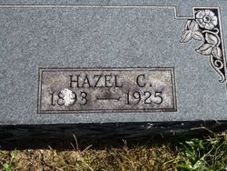
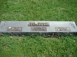
Hazel Christine Cundiff Politte
| Birth | : | 1893 Doe Run, St. Francois County, Missouri, USA |
| Death | : | 11 Nov 1925 Bonne Terre, St. Francois County, Missouri, USA |
| Burial | : | St. Giles Churchyard, South Mimms, Hertsmere Borough, England |
| Coordinate | : | 51.6961860, -0.2329300 |
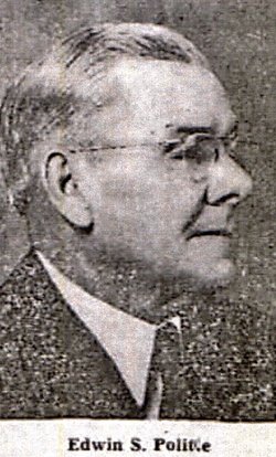
| Description | : | Wife of Edwin S. Politte. |
frequently asked questions (FAQ):
-
Where is Hazel Christine Cundiff Politte's memorial?
Hazel Christine Cundiff Politte's memorial is located at: St. Giles Churchyard, South Mimms, Hertsmere Borough, England.
-
When did Hazel Christine Cundiff Politte death?
Hazel Christine Cundiff Politte death on 11 Nov 1925 in Bonne Terre, St. Francois County, Missouri, USA
-
Where are the coordinates of the Hazel Christine Cundiff Politte's memorial?
Latitude: 51.6961860
Longitude: -0.2329300
Family Members:
Parent

Spouse
Siblings
Flowers:


Nearby Cemetories:
1. St. Giles Churchyard
South Mimms, Hertsmere Borough, England
Coordinate: 51.6961860, -0.2329300
2. St Margaret Churchyard
Ridge, Hertsmere Borough, England
Coordinate: 51.6897880, -0.2455900
3. St Martin's Churchyard
Shenley, Hertsmere Borough, England
Coordinate: 51.6897547, -0.2794666
4. St. Mary's Churchyard
Potters Bar, Hertsmere Borough, England
Coordinate: 51.6926910, -0.1849770
5. Saint Bololph's Churchyard
Shenley, Hertsmere Borough, England
Coordinate: 51.7030296, -0.2890460
6. Hill End Hospital Cemetery
St Albans, St Albans District, England
Coordinate: 51.6982051, -0.2901128
7. Christ Church Burial Ground
Barnet, London Borough of Barnet, England
Coordinate: 51.6597600, -0.2059000
8. St Mary The Virgin Churchyard
Monken Hadley, London Borough of Barnet, England
Coordinate: 51.6615490, -0.1939020
9. Welwyn Hatfield Lawn Cemetery
Welwyn Hatfield, Welwyn Hatfield District, England
Coordinate: 51.7422400, -0.2315670
10. All Saints Churchyard
Borehamwood, Hertsmere Borough, England
Coordinate: 51.6553200, -0.2744900
11. Bells Hill Cemetery
Barnet, London Borough of Barnet, England
Coordinate: 51.6486270, -0.2155210
12. St Peter Churchyard
Arkley, London Borough of Barnet, England
Coordinate: 51.6474200, -0.2320430
13. Christ Church
Radlett, Hertsmere Borough, England
Coordinate: 51.6802460, -0.3163610
14. London Road Cemetery
St Albans, St Albans District, England
Coordinate: 51.7333610, -0.3066110
15. Allum Lane Cemetery
Elstree, Hertsmere Borough, England
Coordinate: 51.6478270, -0.2939220
16. St. Nicholas' Churchyard
Elstree, Hertsmere Borough, England
Coordinate: 51.6450300, -0.2979000
17. Holy Trinity Churchyard
St Albans, St Albans District, England
Coordinate: 51.7170354, -0.3334244
18. Hatfield Estate
Hatfield, Welwyn Hatfield District, England
Coordinate: 51.7606100, -0.2092010
19. St. Etheldreda Churchyard
Hatfield, Welwyn Hatfield District, England
Coordinate: 51.7614490, -0.2120150
20. St. Andrew's Churchyard
Totteridge, London Borough of Barnet, England
Coordinate: 51.6323480, -0.2002220
21. Trent Park Cemetery
Cockfosters, London Borough of Enfield, England
Coordinate: 51.6526730, -0.1499380
22. Frogmore Holy Trinity Burial Ground
St Albans District, England
Coordinate: 51.7197598, -0.3365342
23. St. Luke's Churchyard
Hatfield, Welwyn Hatfield District, England
Coordinate: 51.7643980, -0.2237710
24. Edgwarebury Cemetery
Edgware, London Borough of Barnet, England
Coordinate: 51.6304800, -0.2797200