
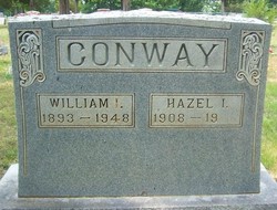
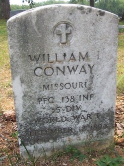
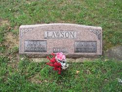
Hazel Irene Lawson Cook
| Birth | : | 1908 Washington County, Missouri, USA |
| Death | : | unknown |
| Burial | : | Oakland Grove Cemetery, Bourne, Barnstable County, USA |
| Coordinate | : | 41.7402992, -70.6042023 |
| Description | : | Married to William Irvin Conway on April 20, 1920 in Concord Township, Missouri Married to Joseph Howard Cook on May 1, 1950 in Potosi, Missouri Died after 1980, before 1988 |
frequently asked questions (FAQ):
-
Where is Hazel Irene Lawson Cook's memorial?
Hazel Irene Lawson Cook's memorial is located at: Oakland Grove Cemetery, Bourne, Barnstable County, USA.
-
When did Hazel Irene Lawson Cook death?
Hazel Irene Lawson Cook death on unknown in
-
Where are the coordinates of the Hazel Irene Lawson Cook's memorial?
Latitude: 41.7402992
Longitude: -70.6042023
Family Members:
Parent

Spouse
Siblings
Children
Flowers:


Nearby Cemetories:
1. Old Bourne Cemetery
Bourne, Barnstable County, USA
Coordinate: 41.7386017, -70.5986023
2. Bourne Village Cemetery
Bourne, Barnstable County, USA
Coordinate: 41.7425117, -70.5938110
3. Monument Neck Cemetery
Gray Gables, Barnstable County, USA
Coordinate: 41.7346001, -70.6128006
4. Bourne Family Cemetery
Bourne, Barnstable County, USA
Coordinate: 41.7501602, -70.6032104
5. Bourne Family Cemetery #02
Bourne, Barnstable County, USA
Coordinate: 41.7577230, -70.6001190
6. Long Neck Cemetery
Wareham, Plymouth County, USA
Coordinate: 41.7461014, -70.6369019
7. Monument Beach Cemetery
Monument Beach, Barnstable County, USA
Coordinate: 41.7151800, -70.6094600
8. Nickerson Burial Ground
Plymouth, Plymouth County, USA
Coordinate: 41.7642740, -70.6306530
9. Pocasset Cemetery
Bourne, Barnstable County, USA
Coordinate: 41.6947260, -70.6034070
10. Bournedale Burying Hill
Bourne, Barnstable County, USA
Coordinate: 41.7741520, -70.5611730
11. Bournedale Herring Pond Indian Cemetery
Bourne, Barnstable County, USA
Coordinate: 41.7861900, -70.5658722
12. Herring Pond Wampanoag Indian Cemetery
Plymouth, Plymouth County, USA
Coordinate: 41.7867290, -70.5658940
13. Sagamore Cemetery
Bourne, Barnstable County, USA
Coordinate: 41.7714005, -70.5339966
14. Cataumet Cemetery
Bourne, Barnstable County, USA
Coordinate: 41.6768990, -70.6063995
15. Agawam Cemetery
Wareham, Plymouth County, USA
Coordinate: 41.7463989, -70.6908035
16. Herring Pond Cemetery
Plymouth, Plymouth County, USA
Coordinate: 41.7971700, -70.5588800
17. Massachusetts National Cemetery
Bourne, Barnstable County, USA
Coordinate: 41.6759987, -70.5824966
18. Saddle and Pillion Cemetery
Sagamore, Barnstable County, USA
Coordinate: 41.7672005, -70.5192032
19. Bay View Cemetery
Sandwich, Barnstable County, USA
Coordinate: 41.7583008, -70.5102997
20. Saint Peters Cemetery
Sandwich, Barnstable County, USA
Coordinate: 41.7502480, -70.5079346
21. Freeman Cemetery
Sandwich, Barnstable County, USA
Coordinate: 41.7573013, -70.5083008
22. Cedarville Cemetery
Plymouth, Plymouth County, USA
Coordinate: 41.8049736, -70.5560837
23. Old Town Cemetery
Sandwich, Barnstable County, USA
Coordinate: 41.7556992, -70.5011978
24. Nightingale Cemetery
Plymouth, Plymouth County, USA
Coordinate: 41.8113400, -70.5588260