
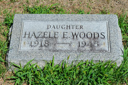
Hazele Estella Woods
| Birth | : | 10 Apr 1918 Dayton, Webster County, Iowa, USA |
| Death | : | 31 Mar 1945 Fort Dodge, Webster County, Iowa, USA |
| Burial | : | Dayton Cemetery, Dayton, Webster County, USA |
| Coordinate | : | 42.2675000, -94.0755000 |
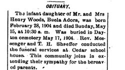
| Description | : | Dayton Review April 5, 1945 RITES FOR DAYTON GIRL TUESDAY Miss Hazelle Woods, daughter of Mr. and Mrs. Henry Woods of Dayton, passed away Saturday at 6:30 p.m. at Lutheran hospital in Fort Dodge. Miss Woods had taken ill about a week before her death but no one realized it was serious until she lapsed into a coma Saturday afternoon. She was rushed to the Lutheran hospital, Fort Dodge, where death came early that evening. Miss Woods attended the Dayton schools and has been employed in Fort Dodge for several years. Her absence will be deeply... Read More |
frequently asked questions (FAQ):
-
Where is Hazele Estella Woods's memorial?
Hazele Estella Woods's memorial is located at: Dayton Cemetery, Dayton, Webster County, USA.
-
When did Hazele Estella Woods death?
Hazele Estella Woods death on 31 Mar 1945 in Fort Dodge, Webster County, Iowa, USA
-
Where are the coordinates of the Hazele Estella Woods's memorial?
Latitude: 42.2675000
Longitude: -94.0755000
Family Members:
Parent
Siblings
Flowers:


Nearby Cemetories:
1. Dayton Cemetery
Dayton, Webster County, USA
Coordinate: 42.2675000, -94.0755000
2. Christ the King Catholic Cemetery
Dayton, Webster County, USA
Coordinate: 42.2601929, -94.0727539
3. Bass Cemetery
Dayton, Webster County, USA
Coordinate: 42.2966995, -94.0149994
4. Swedish Lutheran Church Cemetery
Dayton, Webster County, USA
Coordinate: 42.2175000, -94.1065000
5. Oak Grove Cemetery
Lehigh, Webster County, USA
Coordinate: 42.3438988, -94.0475006
6. Hardin Township Cemetery
Hardin Township, Webster County, USA
Coordinate: 42.2411003, -93.9708023
7. Linn Cemetery
Pilot Mound, Boone County, USA
Coordinate: 42.2045330, -93.9970230
8. Lawn Cemetery
Boone County, USA
Coordinate: 42.1771011, -94.0867996
9. West Lawn Cemetery
Lehigh, Webster County, USA
Coordinate: 42.3616982, -94.0678024
10. McGuire Bend Cemetery
Dayton, Webster County, USA
Coordinate: 42.3410000, -93.9880000
11. Runyan Cemetery
Pilot Mound, Boone County, USA
Coordinate: 42.1749992, -94.0015030
12. Pilot Mound Cemetery
Pilot Mound, Boone County, USA
Coordinate: 42.1636200, -94.0282600
13. Vegors Cemetery
Webster County, USA
Coordinate: 42.3177986, -93.9421997
14. Lost Grove Cemetery
Harcourt, Webster County, USA
Coordinate: 42.2583008, -94.2331009
15. Hooks Point Cemetery
Hamilton County, USA
Coordinate: 42.2944530, -93.9199090
16. Oakwood Cemetery
Stratford, Hamilton County, USA
Coordinate: 42.2942009, -93.9182968
17. Hartman Cemetery
Lehigh, Webster County, USA
Coordinate: 42.3666397, -93.9835627
18. White Cemetery
Boone County, USA
Coordinate: 42.1777992, -93.9636002
19. Border Plains Cemetery
Border Plains, Webster County, USA
Coordinate: 42.3917000, -94.0448000
20. Ober and Scott Cemetery
Duncombe, Webster County, USA
Coordinate: 42.3841390, -93.9982856
21. Union Cemetery
Boxholm, Boone County, USA
Coordinate: 42.1369019, -94.0852966
22. Renner Cemetery
Boone County, USA
Coordinate: 42.1380420, -94.1256570
23. Otho Cemetery
Otho, Webster County, USA
Coordinate: 42.4025002, -94.1153030
24. Schlicht Cemetery
Fraser, Boone County, USA
Coordinate: 42.1444200, -93.9780100