Heinrich Johann “Henry” Weltmer
| Birth | : | 18 Sep 1831 Dauphin County, Pennsylvania, USA |
| Death | : | 26 Aug 1906 Robinson, Brown County, Kansas, USA |
| Burial | : | Ruskington Sleaford Road Cemetery, Ruskington, North Kesteven District, England |
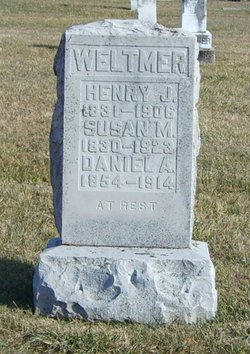
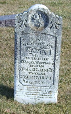
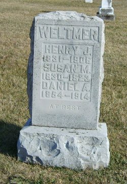
| Description | : | Son of Daniel & Nancy Ann (Chubb) Weltmer. He married Susan M. Hinkle Feb 13, 1851. He went by 'Henry John', and the 1880 census lists him as "Henry J. Weltmer". His wife & son are on the same stone. DEATHS. Weltmer--Henry J. Weltmer was born Doniphan county, Penn., Sept. 18, 1831, and died at Robinson, Aug. 26, 1906, aged 74 years, 11 months and 8 days. He was united in marriage to Susan M. Hinkle, Feb. 13, 1851. Mr. and Mrs. Weltmer moved from Pennsylvania to Missouri in 1851 and to Brown county, Kansas in 1868, where they have since... Read More |
frequently asked questions (FAQ):
-
Where is Heinrich Johann “Henry” Weltmer's memorial?
Heinrich Johann “Henry” Weltmer's memorial is located at: Ruskington Sleaford Road Cemetery, Ruskington, North Kesteven District, England.
-
When did Heinrich Johann “Henry” Weltmer death?
Heinrich Johann “Henry” Weltmer death on 26 Aug 1906 in Robinson, Brown County, Kansas, USA
Family Members:
Parent
Spouse
Siblings
Children
Flowers:
Nearby Cemetories:
1. St Denys' Churchyard
Aswarby, North Kesteven District, England
Coordinate: 53.1637001, -0.4151000
2. St. Oswald's Churchyard
Blankney, North Kesteven District, England
Coordinate: 53.1204000, -0.6795000
3. Brant Broughton Quaker Burial Ground
Brant Broughton, North Kesteven District, England
Coordinate: 53.1203200, -0.6716900
4. St Helen's Churchyard
Brant Broughton, North Kesteven District, England
Coordinate: 53.1203000, -0.6717000
5. All Saints Churchyard
Coleby, North Kesteven District, England
Coordinate: 53.1696789, -0.5998978
6. All Saints Far Lane Churchyard Extension
Coleby, North Kesteven District, England
7. Dunston Back Lane Cemetery
Dunston, North Kesteven District, England
Coordinate: 52.9035930, -0.4252890
8. St Peters Churchyard
Dunston, North Kesteven District, England
Coordinate: 53.0420800, -0.3397200
9. Great Hale New Cemetery
Great Hale, North Kesteven District, England
Coordinate: 53.0414520, -0.3391170
10. St John the Baptist Churchyard
Great Hale, North Kesteven District, England
Coordinate: 52.9367820, -0.4470450
11. St. Oswald's Churchyard
Howell, North Kesteven District, England
12. St Andrew Churchyard
Leasingham, North Kesteven District, England
Coordinate: 53.2159000, -0.5236900
13. All Saints Churchyard
Nocton, North Kesteven District, England
Coordinate: 53.1637001, -0.4151000
14. St Michael's Church
Norton Disney, North Kesteven District, England
Coordinate: 53.1204000, -0.6795000
15. St Peter's Churchyard
Norton Disney, North Kesteven District, England
Coordinate: 53.1203200, -0.6716900
16. St. Peter's Churchyard
Norton Disney, North Kesteven District, England
Coordinate: 53.1203000, -0.6717000
17. Saint Michael's Churchyard
South Hykeham, North Kesteven District, England
Coordinate: 53.1696789, -0.5998978
18. St Michael's Church Cemetery
Swaton, North Kesteven District, England
19. St Nicholas Churchyard
Walcot, North Kesteven District, England
Coordinate: 52.9035930, -0.4252890
20. Anwick Church Lane Churchyard Extension
Anwick, North Kesteven District, England
Coordinate: 53.0420800, -0.3397200
21. St Edith's Church
Anwick, North Kesteven District, England
Coordinate: 53.0414520, -0.3391170
22. St Thomas Churchyard
Aunsby, North Kesteven District, England
Coordinate: 52.9367820, -0.4470450
23. Saint Mary the Virgin Churchyard
Bloxholm, North Kesteven District, England
24. All Saints Churchyard
Canwick, North Kesteven District, England
Coordinate: 53.2159000, -0.5236900

