
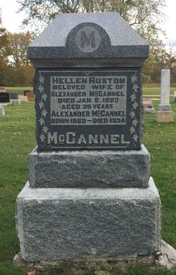
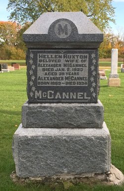
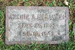
Helen Ruxton McCannel
| Birth | : | 6 Jul 1884 Amabel Township, Bruce County, Ontario, Canada |
| Death | : | 2 Jan 1923 Ontario, Canada |
| Burial | : | Seal Harbor Cemetery, Seal Harbor, Hancock County, USA |
| Coordinate | : | 44.3110972, -68.2455624 |
| Plot | : | Section K, Row 16 |
| Description | : | Port Elgin Times August 6, 1908 McCannel-Ruxton The home of Mr. Andrew Ruxton, Chippewa Hill, was the scene of a very pretty wedding on the morning of July 28th when his sister Miss Helen became the bride of Mr. Alex. McCannel, one of Burgoyne's popular young bachelors. Precisely at 10 A. M. the bride and groom who were unattended took places beneath a beautiful arch of evergreen and white flowers, the bride being given away by her brother. The marriage ceremony was performed by Rev. R. T. Cockburn, Ph. B., of Southampton, assisted by Rev. J- Rex Brown, of Burgoyne. After the usual congratulations, etc,... Read More |
frequently asked questions (FAQ):
-
Where is Helen Ruxton McCannel's memorial?
Helen Ruxton McCannel's memorial is located at: Seal Harbor Cemetery, Seal Harbor, Hancock County, USA.
-
When did Helen Ruxton McCannel death?
Helen Ruxton McCannel death on 2 Jan 1923 in Ontario, Canada
-
Where are the coordinates of the Helen Ruxton McCannel's memorial?
Latitude: 44.3110972
Longitude: -68.2455624
Family Members:
Parent

Spouse

Siblings
Children
Flowers:


Nearby Cemetories:
1. Seal Harbor Cemetery
Seal Harbor, Hancock County, USA
Coordinate: 44.3110972, -68.2455624
2. Otter Creek Cemetery
Otter Creek, Hancock County, USA
Coordinate: 44.3136378, -68.2117624
3. Savage Graves
Mount Desert, Hancock County, USA
Coordinate: 44.2902015, -68.2684730
4. Forest Hill Cemetery
Northeast Harbor, Hancock County, USA
Coordinate: 44.3112670, -68.2839830
5. Kimball Cemetery
Northeast Harbor, Hancock County, USA
Coordinate: 44.2900009, -68.2874985
6. Stanley-Hadlock Cemetery
Cranberry Isles, Hancock County, USA
Coordinate: 44.2638363, -68.2375932
7. Brown Cemetery
Mount Desert, Hancock County, USA
Coordinate: 44.3389167, -68.3014496
8. Stanley-Gilley Cemetery
Cranberry Isles, Hancock County, USA
Coordinate: 44.2616981, -68.2312870
9. Harding Point Cemetery
Cranberry Isles, Hancock County, USA
Coordinate: 44.2582923, -68.2596894
10. Sand Beach Cemetery
Islesford, Hancock County, USA
Coordinate: 44.2560133, -68.2389235
11. Spurling Revolutionary War Cemetery
Cranberry Isles, Hancock County, USA
Coordinate: 44.2589580, -68.2717591
12. Maypole Point - Standley Grave
Cranberry Isles, Hancock County, USA
Coordinate: 44.2543790, -68.2392860
13. Gilley Burying Ground
Southwest Harbor, Hancock County, USA
Coordinate: 44.2911921, -68.3225843
14. Clark Family Burying Ground
Southwest Harbor, Hancock County, USA
Coordinate: 44.2779701, -68.3135589
15. Schooner Head Cemetery
Mount Desert, Hancock County, USA
Coordinate: 44.3440810, -68.1761900
16. Evergreen Cemetery
Southwest Harbor, Hancock County, USA
Coordinate: 44.3002130, -68.3288970
17. Preble Cemetery
Cranberry Isles, Hancock County, USA
Coordinate: 44.2522747, -68.2700609
18. Old Burying Ground
Southwest Harbor, Hancock County, USA
Coordinate: 44.2802164, -68.3199704
19. Hillside Cemetery
Mount Desert, Hancock County, USA
Coordinate: 44.3587146, -68.3043880
20. King Cemetery
Southwest Harbor, Hancock County, USA
Coordinate: 44.2630830, -68.3037780
21. Lurvey Burial Ground
Southwest Harbor, Hancock County, USA
Coordinate: 44.2989000, -68.3328000
22. Newman Cemetery
Southwest Harbor, Hancock County, USA
Coordinate: 44.2581672, -68.2976396
23. Union Cemetery
Southwest Harbor, Hancock County, USA
Coordinate: 44.2649994, -68.3103027
24. Bunker Cemetery
Cranberry Isles, Hancock County, USA
Coordinate: 44.2443697, -68.2611576