
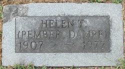
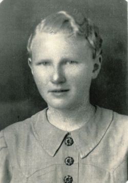
Helen Thalia Campbell Renken
| Birth | : | 9 Jan 1907 Olean, Miller County, Missouri, USA |
| Death | : | 22 Dec 1977 Jefferson City, Cole County, Missouri, USA |
| Burial | : | Olean Cemetery, Olean, Miller County, USA |
| Coordinate | : | 38.4131012, -92.5413971 |
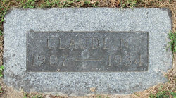
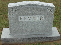
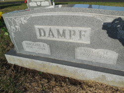
| Description | : | Daily Capital News, Friday, December 23, 1977, Jefferson City, Missouri Mrs. Helen T. Dampf, 70, died Thursday at St. Mary's Health Center. She was born Jan. 9, 1907, at Olean, the daughter of George and Laura Enloe Campbell. She was first married in 1926 to Claude Renken, who died Apr, 3, 1934. She was later married on July 17, 1941 to Ivan Pember who died Sept. 30, 1961. On Dec. 17, 1966 she married Herschel Dampf, who died March 31, 1976. Mrs. Dampf was a member of the First Baptist Church of Eldon. Survivors include three daughters, Mrs. Juanita Rey, St. Louis,... Read More |
frequently asked questions (FAQ):
-
Where is Helen Thalia Campbell Renken's memorial?
Helen Thalia Campbell Renken's memorial is located at: Olean Cemetery, Olean, Miller County, USA.
-
When did Helen Thalia Campbell Renken death?
Helen Thalia Campbell Renken death on 22 Dec 1977 in Jefferson City, Cole County, Missouri, USA
-
Where are the coordinates of the Helen Thalia Campbell Renken's memorial?
Latitude: 38.4131012
Longitude: -92.5413971
Family Members:
Parent
Spouse
Siblings
Children

Flowers:


Nearby Cemetories:
1. Olean Cemetery
Olean, Miller County, USA
Coordinate: 38.4131012, -92.5413971
2. Green Ridge Baptist Church Cemetery
Eldon, Miller County, USA
Coordinate: 38.4116200, -92.5645700
3. Etter-Walker Cemetery
Burris Fork, Moniteau County, USA
Coordinate: 38.4333700, -92.5525400
4. Walker Cemetery
Moniteau County, USA
Coordinate: 38.4338989, -92.5522003
5. Farris Cemetery
Moniteau County, USA
Coordinate: 38.4369900, -92.5380000
6. Allen Cemetery
Olean, Miller County, USA
Coordinate: 38.4150009, -92.5008011
7. Jackson Chapel Methodist Church Cemetery
California, Moniteau County, USA
Coordinate: 38.4447900, -92.5286500
8. Gray Cemetery
Moniteau County, USA
Coordinate: 38.4536018, -92.5456009
9. Hite Cemetery
Miller County, USA
Coordinate: 38.4039001, -92.5935974
10. Mount Pleasant Cemetery
Eldon, Miller County, USA
Coordinate: 38.3667700, -92.5300800
11. Salem Cemetery
Saline Township, Miller County, USA
Coordinate: 38.3691232, -92.5697260
12. Salem Cemetery
Eldon, Miller County, USA
Coordinate: 38.3697014, -92.5714035
13. Mount Vernon Cemetery
Eldon, Miller County, USA
Coordinate: 38.3624992, -92.5606003
14. Bruce-Lewis-McGahan Cemetery
Enon, Moniteau County, USA
Coordinate: 38.4667500, -92.5172100
15. Rock Enon Cemetery
Miller County, USA
Coordinate: 38.4668400, -92.5170700
16. Eldon Cemetery
Eldon, Miller County, USA
Coordinate: 38.3642006, -92.5868988
17. Phillips Cemetery
High Point, Moniteau County, USA
Coordinate: 38.4430300, -92.6125300
18. Colburn Cemetery
Eldon, Miller County, USA
Coordinate: 38.4246300, -92.6275500
19. Depp Cemetery
High Point, Moniteau County, USA
Coordinate: 38.4776400, -92.5818500
20. High Point Cemetery
High Point, Moniteau County, USA
Coordinate: 38.4817009, -92.5757980
21. Phillips Cemetery
Barnett, Morgan County, USA
Coordinate: 38.4227982, -92.6367035
22. Matheis Cemetery
Russellville, Cole County, USA
Coordinate: 38.4571800, -92.4491600
23. United Baptist Church Cemetery
High Point, Moniteau County, USA
Coordinate: 38.4962200, -92.5856800
24. Karnes-Carney-Henderson Cemetery
Burris Fork, Moniteau County, USA
Coordinate: 38.4992100, -92.5007510