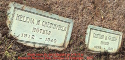
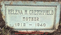
Helena Hortense Pointer Cretchfield
| Birth | : | 19 Aug 1912 Missouri, USA |
| Death | : | 20 Aug 1940 Los Angeles County, California, USA |
| Burial | : | Roosevelt Memorial Park, Gardena, Los Angeles County, USA |
| Coordinate | : | 33.8643990, -118.2947006 |
| Description | : | Helena is buried next to Esther Grider, at first, it was thought that she may be the daughter of Esther, after coming back home and researching her name on ancestry, it was discovered her parents were Samuel Robert Pointer and Forrestine M. Douglas. The markers while the same style is probably just a coincidence. Multiple family trees spell her spouse's name, Eugene Parks Critchfield with an I, not an E, they reflect him being married in 1940 to a Gladys Arline Mosher, Eugene died on 21 Aug 2000 in San Ramon, CA. Helena Hortense Pointer in the California, County Birth, Marriage,... Read More |
frequently asked questions (FAQ):
-
Where is Helena Hortense Pointer Cretchfield's memorial?
Helena Hortense Pointer Cretchfield's memorial is located at: Roosevelt Memorial Park, Gardena, Los Angeles County, USA.
-
When did Helena Hortense Pointer Cretchfield death?
Helena Hortense Pointer Cretchfield death on 20 Aug 1940 in Los Angeles County, California, USA
-
Where are the coordinates of the Helena Hortense Pointer Cretchfield's memorial?
Latitude: 33.8643990
Longitude: -118.2947006
Family Members:
Parent
Siblings
Flowers:
Nearby Cemetories:
1. Roosevelt Memorial Park
Gardena, Los Angeles County, USA
Coordinate: 33.8643990, -118.2947006
2. Pet Haven Cemetery
Gardena, Los Angeles County, USA
Coordinate: 33.8642006, -118.2807999
3. Gardena Buddhist Church
Gardena, Los Angeles County, USA
Coordinate: 33.8804950, -118.3023170
4. Lincoln Memorial Park
Carson, Los Angeles County, USA
Coordinate: 33.8806000, -118.2521973
5. Woodlawn Memorial Park
Compton, Los Angeles County, USA
Coordinate: 33.8812700, -118.2468800
6. First Lutheran Church and School
Torrance, Los Angeles County, USA
Coordinate: 33.8310400, -118.3388000
7. Pacific Crest Cemetery
Redondo Beach, Los Angeles County, USA
Coordinate: 33.8675003, -118.3591995
8. Wilmington Cemetery
Wilmington, Los Angeles County, USA
Coordinate: 33.7922300, -118.2550900
9. Angeles Abbey Memorial Park
Compton, Los Angeles County, USA
Coordinate: 33.8982887, -118.2065582
10. Saint Lawrence Martyr Church Columbarium
Redondo Beach, Los Angeles County, USA
Coordinate: 33.8177012, -118.3767580
11. Drum Barracks Cemetery (Defunct)
Wilmington, Los Angeles County, USA
Coordinate: 33.7855320, -118.2533170
12. Saint Cross Episcopal Church Columbarium
Hermosa Beach, Los Angeles County, USA
Coordinate: 33.8673040, -118.3996600
13. South Coast Botanical Garden
Palos Verdes Estates, Los Angeles County, USA
Coordinate: 33.7844800, -118.3480100
14. Green Hills Memorial Park
Rancho Palos Verdes, Los Angeles County, USA
Coordinate: 33.7731018, -118.3133011
15. Hollywood Park Race Track
Inglewood, Los Angeles County, USA
Coordinate: 33.9503600, -118.3412000
16. Forest Lawn Memorial Park
Long Beach, Los Angeles County, USA
Coordinate: 33.8436012, -118.1691971
17. Palm Cemetery
Long Beach, Los Angeles County, USA
Coordinate: 33.8447200, -118.1682500
18. Inglewood Park Cemetery
Inglewood, Los Angeles County, USA
Coordinate: 33.9674988, -118.3380966
19. All Souls Cemetery
Long Beach, Los Angeles County, USA
Coordinate: 33.8405991, -118.1647034
20. Sunnyside Cemetery
Long Beach, Los Angeles County, USA
Coordinate: 33.8044700, -118.1789100
21. Long Beach Municipal Cemetery
Long Beach, Los Angeles County, USA
Coordinate: 33.8044700, -118.1769200
22. Saint John Fisher Columbarium
Rancho Palos Verdes, Los Angeles County, USA
Coordinate: 33.7626800, -118.3693600
23. Los Angeles County Farm Cemetery
Downey, Los Angeles County, USA
Coordinate: 33.9235609, -118.1694582
24. Saint Peters Episcopal Church Columbarium
San Pedro, Los Angeles County, USA
Coordinate: 33.7370500, -118.3136400


