
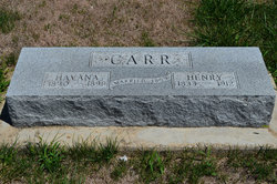
Henry Carr
| Birth | : | 10 Dec 1833 Rockingham County, Virginia, USA |
| Death | : | 26 Dec 1912 Dayton, Webster County, Iowa, USA |
| Burial | : | Dayton Cemetery, Dayton, Webster County, USA |
| Coordinate | : | 42.2675000, -94.0755000 |
| Plot | : | Section 2 |
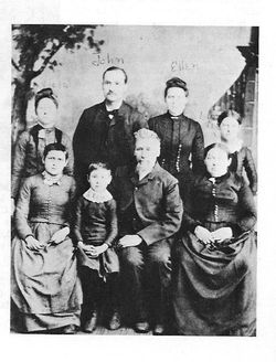
| Description | : | Excerpt from "The Biographical Record of Webster County, Iowa", published in 1902. "Henry Carr, one of Dayton's most prosperous and influential citizens, was born in Rockingham County, Virginia. His parents continued to reside there until 1837, when they removed to Jacksonburg, Indiana. During his boyhood, Henry pursued his education in a log schoolhouse at Jacksonburg, Wayne County, Indiana.---After the completion of his education at the age of twenty years, he remained in Indiana until 1855, and then came to Webster County, Iowa, where he entered one hundred and sixty acres in Wayne County, this state. He then returned... Read More |
frequently asked questions (FAQ):
-
Where is Henry Carr's memorial?
Henry Carr's memorial is located at: Dayton Cemetery, Dayton, Webster County, USA.
-
When did Henry Carr death?
Henry Carr death on 26 Dec 1912 in Dayton, Webster County, Iowa, USA
-
Where are the coordinates of the Henry Carr's memorial?
Latitude: 42.2675000
Longitude: -94.0755000
Family Members:
Parent
Spouse

Siblings
Children

Flowers:


Nearby Cemetories:
1. Dayton Cemetery
Dayton, Webster County, USA
Coordinate: 42.2675000, -94.0755000
2. Christ the King Catholic Cemetery
Dayton, Webster County, USA
Coordinate: 42.2601929, -94.0727539
3. Bass Cemetery
Dayton, Webster County, USA
Coordinate: 42.2966995, -94.0149994
4. Swedish Lutheran Church Cemetery
Dayton, Webster County, USA
Coordinate: 42.2175000, -94.1065000
5. Oak Grove Cemetery
Lehigh, Webster County, USA
Coordinate: 42.3438988, -94.0475006
6. Hardin Township Cemetery
Hardin Township, Webster County, USA
Coordinate: 42.2411003, -93.9708023
7. Linn Cemetery
Pilot Mound, Boone County, USA
Coordinate: 42.2045330, -93.9970230
8. Lawn Cemetery
Boone County, USA
Coordinate: 42.1771011, -94.0867996
9. West Lawn Cemetery
Lehigh, Webster County, USA
Coordinate: 42.3616982, -94.0678024
10. McGuire Bend Cemetery
Dayton, Webster County, USA
Coordinate: 42.3410000, -93.9880000
11. Runyan Cemetery
Pilot Mound, Boone County, USA
Coordinate: 42.1749992, -94.0015030
12. Pilot Mound Cemetery
Pilot Mound, Boone County, USA
Coordinate: 42.1636200, -94.0282600
13. Vegors Cemetery
Webster County, USA
Coordinate: 42.3177986, -93.9421997
14. Lost Grove Cemetery
Harcourt, Webster County, USA
Coordinate: 42.2583008, -94.2331009
15. Hooks Point Cemetery
Hamilton County, USA
Coordinate: 42.2944530, -93.9199090
16. Oakwood Cemetery
Stratford, Hamilton County, USA
Coordinate: 42.2942009, -93.9182968
17. Hartman Cemetery
Lehigh, Webster County, USA
Coordinate: 42.3666397, -93.9835627
18. White Cemetery
Boone County, USA
Coordinate: 42.1777992, -93.9636002
19. Border Plains Cemetery
Border Plains, Webster County, USA
Coordinate: 42.3917000, -94.0448000
20. Ober and Scott Cemetery
Duncombe, Webster County, USA
Coordinate: 42.3841390, -93.9982856
21. Union Cemetery
Boxholm, Boone County, USA
Coordinate: 42.1369019, -94.0852966
22. Renner Cemetery
Boone County, USA
Coordinate: 42.1380420, -94.1256570
23. Otho Cemetery
Otho, Webster County, USA
Coordinate: 42.4025002, -94.1153030
24. Schlicht Cemetery
Fraser, Boone County, USA
Coordinate: 42.1444200, -93.9780100