

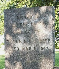
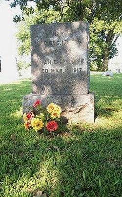
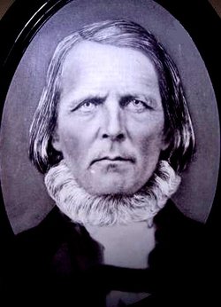
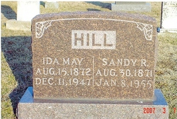
Henry Clay Hill
| Birth | : | 1832 Moniteau County, Missouri, USA |
| Death | : | 17 Dec 1920 Moniteau County, Missouri, USA |
| Burial | : | Saint George Cemetery, Southbridge, Worcester County, USA |
| Coordinate | : | 42.0833015, -72.0353012 |
| Inscription | : | Aged: 88 Y |
| Description | : | Henry C. Hill. Birth: 1831 (based on age). Birth County: Moniteau. Birth State: Missouri. Death Date: April 26, 1936. Death Township: Walker. Death County: Moniteau. Death State: Missouri. Father: Sandy Hill. Birth State: Kentucky. Mother: Susan Hays. Birth State: Tennessee. Informant: Bryse Hill. Occupation: Farmer. Marital Status: Widowed. Age: 89 Years. Gender: Male. Race: White. Cause Of Death: Chronic Heptestis. Cemetery: Sappington Graveyard. Burial: April 18, 1920. Source: Death Certificate: #37389. Researcher: Richard Parker. NOTE: Henry is buried in the Sappington Community Chapel Cemetery south of California, Missouri and not the Sappington Cemetery near Clarksbrug, Missouri.. . |
frequently asked questions (FAQ):
-
Where is Henry Clay Hill's memorial?
Henry Clay Hill's memorial is located at: Saint George Cemetery, Southbridge, Worcester County, USA.
-
When did Henry Clay Hill death?
Henry Clay Hill death on 17 Dec 1920 in Moniteau County, Missouri, USA
-
Where are the coordinates of the Henry Clay Hill's memorial?
Latitude: 42.0833015
Longitude: -72.0353012
Family Members:
Parent

Spouse
Siblings
Children


Nearby Cemetories:
1. Saint George Cemetery
Southbridge, Worcester County, USA
Coordinate: 42.0833015, -72.0353012
2. Saint Marys Cemetery
Southbridge, Worcester County, USA
Coordinate: 42.0805900, -72.0242000
3. Old Notre Dame Cemetery
Southbridge, Worcester County, USA
Coordinate: 42.0806900, -72.0228200
4. Oak Ridge Cemetery
Southbridge, Worcester County, USA
Coordinate: 42.0718430, -72.0325680
5. Saint Hedwig Cemetery
Southbridge, Worcester County, USA
Coordinate: 42.0456000, -72.0141400
6. Old Burial Ground
Sturbridge, Worcester County, USA
Coordinate: 42.1074500, -72.0805700
7. New Notre Dame Cemetery
Southbridge, Worcester County, USA
Coordinate: 42.0443990, -72.0138680
8. North Cemetery
Sturbridge, Worcester County, USA
Coordinate: 42.1128006, -72.0768967
9. Dresser Cemetery
Charlton, Worcester County, USA
Coordinate: 42.0949300, -71.9788800
10. Barefoot Cemetery
Charlton, Worcester County, USA
Coordinate: 42.1307800, -72.0231100
11. Morse Cemetery
Southbridge, Worcester County, USA
Coordinate: 42.0381860, -72.0114000
12. Blackmer Cemetery
Dudley, Worcester County, USA
Coordinate: 42.0518500, -71.9814700
13. Fitts Burial Yard
Charlton, Worcester County, USA
Coordinate: 42.0920900, -71.9550900
14. Chase Family Plot
Dudley, Worcester County, USA
Coordinate: 42.0807000, -71.9539000
15. Albee-Durfee Cemetery
Dudley, Worcester County, USA
Coordinate: 42.0527992, -71.9593964
16. Saint Anne Cemetery
Sturbridge, Worcester County, USA
Coordinate: 42.1185989, -72.1082993
17. Browning Cemetery
Dudley, Worcester County, USA
Coordinate: 42.0505560, -71.9555600
18. Union Cemetery
Charlton, Worcester County, USA
Coordinate: 42.1444016, -71.9957962
19. Bay Path Cemetery
Charlton, Worcester County, USA
Coordinate: 42.1308320, -71.9687870
20. Westridge Cemetery
Charlton, Worcester County, USA
Coordinate: 42.1344890, -71.9724550
21. Waldron Cemetery
Dudley, Worcester County, USA
Coordinate: 42.0697100, -71.9413700
22. Quinebaug Cemetery
Dudley, Worcester County, USA
Coordinate: 42.0335500, -71.9601100
23. Corbin Cemetery
Dudley, Worcester County, USA
Coordinate: 42.0548100, -71.9280900
24. Village Cemetery
Dudley, Worcester County, USA
Coordinate: 42.0494800, -71.9274000