Henry Clay White
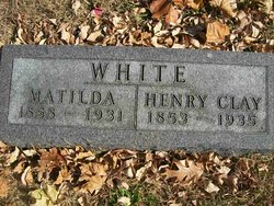
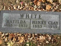
| Birth | : | 2 Jan 1853 Dade County, Missouri, USA |
| Death | : | 28 Jul 1935 Jackson County, Kansas, USA |
| Burial | : | Old Westside Cemetery, Edgartown, Dukes County, USA |
| Coordinate | : | 41.3892200, -70.5182400 |
| Plot | : | Section C |
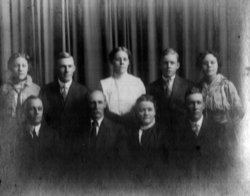
| Description | : | In the death of Henry Clay White, which occured July 28, Jackson county had been his home. He was the son of George and Margaret White and was born in Dade county, Mo., January 2, 1853, and came to Kansas with his parents the spring of 1861, settling on Soldier creek, west of Holton, later moving to Denison where he grew to manhood. He was married September 7, 1876, to Matilda Hollenbeck, who was his devoted companion for fifty-two years, passing away October 18, 1931. They had eight children. Three daughters are not living. Surviving are Jesse of Kansas City, Roy... Read More |
frequently asked questions (FAQ):
-
Where is Henry Clay White's memorial?
Henry Clay White's memorial is located at: Old Westside Cemetery, Edgartown, Dukes County, USA.
-
When did Henry Clay White death?
Henry Clay White death on 28 Jul 1935 in Jackson County, Kansas, USA
-
Where are the coordinates of the Henry Clay White's memorial?
Latitude: 41.3892200
Longitude: -70.5182400
Family Members:
Parent
Spouse
Siblings
Children
Flowers:
Nearby Cemetories:
1. Old Westside Cemetery
Edgartown, Dukes County, USA
Coordinate: 41.3892200, -70.5182400
2. New Westside Cemetery
Edgartown, Dukes County, USA
Coordinate: 41.3887600, -70.5208200
3. Federated Church Memorial Garden
Edgartown, Dukes County, USA
Coordinate: 41.3884800, -70.5149500
4. Tower Hill Cemetery
Edgartown, Dukes County, USA
Coordinate: 41.3809600, -70.5112400
5. Hilltop Cemetery
Edgartown, Dukes County, USA
Coordinate: 41.3862000, -70.4700800
6. Toms Neck Farm Cemetery
Edgartown, Dukes County, USA
Coordinate: 41.3780900, -70.4600200
7. Sarah Wilbur Gravesite
Oak Bluffs, Dukes County, USA
Coordinate: 41.4156700, -70.5819800
8. Farm Neck Cemetery
Oak Bluffs, Dukes County, USA
Coordinate: 41.4278800, -70.5709300
9. Smith Family Cemetery
Oak Bluffs, Dukes County, USA
Coordinate: 41.4243020, -70.6005530
10. Sacred Heart Cemetery
Oak Bluffs, Dukes County, USA
Coordinate: 41.4533800, -70.5714100
11. Oak Grove Cemetery
Oak Bluffs, Dukes County, USA
Coordinate: 41.4555600, -70.5680200
12. Graves near Old House Pond
West Tisbury, Dukes County, USA
Coordinate: 41.4192700, -70.6130400
13. Eastville Cemetery
Oak Bluffs, Dukes County, USA
Coordinate: 41.4575400, -70.5803200
14. Sailors Burying Ground
Tisbury, Dukes County, USA
Coordinate: 41.4402600, -70.6146000
15. South End Cemetery
Tisbury, Dukes County, USA
Coordinate: 41.4513100, -70.6045900
16. Tisbury Village Cemetery
Tisbury, Dukes County, USA
Coordinate: 41.4545600, -70.6053300
17. Grace Episcopal Churchyard
Vineyard Haven, Dukes County, USA
Coordinate: 41.4581253, -70.6048724
18. Oak Grove Cemetery
Tisbury, Dukes County, USA
Coordinate: 41.4514008, -70.6138992
19. Daggett Burial Ground
Tisbury, Dukes County, USA
Coordinate: 41.4461200, -70.6201800
20. Marthas Vineyard Hebrew Cemetery
Tisbury, Dukes County, USA
Coordinate: 41.4515900, -70.6144520
21. West Chop Cemetery
Tisbury, Dukes County, USA
Coordinate: 41.4679400, -70.5998400
22. West Tisbury Village Cemetery
West Tisbury, Dukes County, USA
Coordinate: 41.3875600, -70.6739800
23. North Tisbury Burial Ground
West Tisbury, Dukes County, USA
Coordinate: 41.4067800, -70.6771800
24. Lambert's Cove Cemetery
West Tisbury, Dukes County, USA
Coordinate: 41.4451500, -70.6626000

