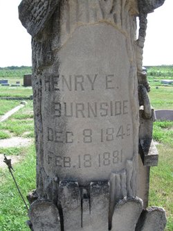
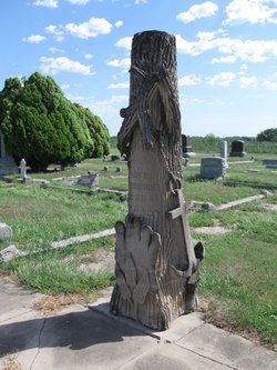
Henry E. Burnside
| Birth | : | 8 Dec 1849 |
| Death | : | 18 Feb 1881 Cloud County, Kansas, USA |
| Burial | : | Farmington Cemetery, Macksville, Stafford County, USA |
| Coordinate | : | 37.9574510, -98.9608270 |
| Plot | : | Lot 62 |
| Description | : | The Concordia Republican Concordia, Kansas Thursday, February 24, 1881 page 4 Died.- On Friday evening, February 18, 1881, of Consumption, Henry Burnside, aged 30 years. And thus another soldier has paid the penalty for disease contracted in a southern camp; and one more of the old 11th Michigan infantry has answered the last roll call here below. Mr. Burnside had been an invalid for some time, and was fully aware of the danger that was threatening him. Brave and patient to the last. Before his death he made a request as... Read More |
frequently asked questions (FAQ):
-
Where is Henry E. Burnside's memorial?
Henry E. Burnside's memorial is located at: Farmington Cemetery, Macksville, Stafford County, USA.
-
When did Henry E. Burnside death?
Henry E. Burnside death on 18 Feb 1881 in Cloud County, Kansas, USA
-
Where are the coordinates of the Henry E. Burnside's memorial?
Latitude: 37.9574510
Longitude: -98.9608270
Family Members:
Parent
Spouse
Siblings
Children
Flowers:
Nearby Cemetories:
1. Farmington Cemetery
Macksville, Stafford County, USA
Coordinate: 37.9574510, -98.9608270
2. Township Cemetery
Macksville, Stafford County, USA
Coordinate: 37.9569016, -98.9582977
3. Neelands Cemetery
St. John, Stafford County, USA
Coordinate: 37.9000015, -98.8660965
4. Belpre Cemetery
Belpre, Edwards County, USA
Coordinate: 37.9528950, -99.1017510
5. Prattsburg Cemetery
Macksville, Stafford County, USA
Coordinate: 37.8283005, -99.0044022
6. Devore Family Cemetery
St. John, Stafford County, USA
Coordinate: 38.0141200, -98.7947700
7. Martin Cemetery
St. John, Stafford County, USA
Coordinate: 37.9564018, -98.7742004
8. Hopewell Cemetery
Hopewell, Pratt County, USA
Coordinate: 37.8058500, -99.0005600
9. Pleasant Valley Cemetery
Larned, Pawnee County, USA
Coordinate: 38.0718994, -99.0955963
10. Byers Cemetery
Byers, Pratt County, USA
Coordinate: 37.7961006, -98.8756027
11. Fairview Park Cemetery
St. John, Stafford County, USA
Coordinate: 38.0078380, -98.7456540
12. Point View Cemetery
Pawnee County, USA
Coordinate: 38.1306000, -98.9131012
13. Fertig Cemetery
Pawnee County, USA
Coordinate: 38.1458015, -98.9492035
14. Wayne Cemetery
Lewis, Edwards County, USA
Coordinate: 37.9550018, -99.2144012
15. Pleasant Plains Cemetery
Byers, Pratt County, USA
Coordinate: 37.7616300, -98.9033500
16. Rose Valley Cemetery
Stafford, Stafford County, USA
Coordinate: 37.8616982, -98.7285995
17. Leesburg Cemetery
Stafford County, USA
Coordinate: 37.8993988, -98.6913986
18. Fellsburg Cemetery
Edwards County, USA
Coordinate: 37.8069000, -99.1688995
19. Providence Cemetery
Edwards County, USA
Coordinate: 37.7336006, -99.0511017
20. Prairie Chapel Cemetery
Stafford County, USA
Coordinate: 37.8978004, -98.6493988
21. Verning Cemetery
Stafford, Stafford County, USA
Coordinate: 37.9986000, -98.6438980
22. Larned State Hospital Cemetery
Larned, Pawnee County, USA
Coordinate: 38.1722800, -99.1566200
23. Larned Cemetery
Larned, Pawnee County, USA
Coordinate: 38.1861000, -99.1333008
24. Garfield Cemetery
Garfield, Pawnee County, USA
Coordinate: 38.0738983, -99.2667007


