
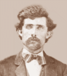

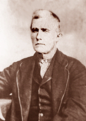
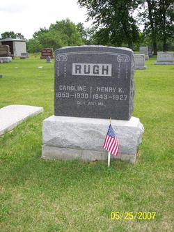
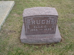
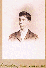
Henry Keck Rugh
| Birth | : | 22 Jan 1843 Greensburg, Westmoreland County, Pennsylvania, USA |
| Death | : | 22 Feb 1927 Memphis, Scotland County, Missouri, USA |
| Burial | : | Greenwood Cemetery, Carman, Pembina Valley Census Division, Canada |
| Coordinate | : | 49.4946700, -97.9995100 |
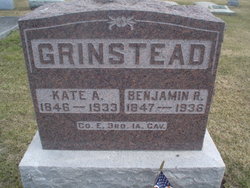
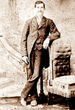
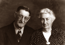
| Description | : | Private Co. I, 21st Regiment, Missouri Volunteer Infantry Henry Rugh Residence was not listed; Enlisted as a Private (date unknown). "I" Co. MO 21st Infantry Henry Keck Rugh, son of Michael (John Michael) Rugh and Ruey (Zeruah) Williams, was born in Westmoreland County, Pennsylvania on January 22, 1843. He fought for the Union at the Battle of Shiloh during the civil war, was captured, and spent about a year as a confederate prisoner. He was later exchanged and after re-enlistment, finished out the war serving elsewhere within his regiment, the... Read More |
frequently asked questions (FAQ):
-
Where is Henry Keck Rugh's memorial?
Henry Keck Rugh's memorial is located at: Greenwood Cemetery, Carman, Pembina Valley Census Division, Canada.
-
When did Henry Keck Rugh death?
Henry Keck Rugh death on 22 Feb 1927 in Memphis, Scotland County, Missouri, USA
-
Where are the coordinates of the Henry Keck Rugh's memorial?
Latitude: 49.4946700
Longitude: -97.9995100
Family Members:
Parent
Spouse
Siblings
Children
Flowers:


Nearby Cemetories:
1. Greenwood Cemetery
Carman, Pembina Valley Census Division, Canada
Coordinate: 49.4946700, -97.9995100
2. Our Lady of Mount Carmel Catholic Cemetery
Carman, Pembina Valley Census Division, Canada
Coordinate: 49.4946100, -98.0014100
3. Riverside Cemetery
Graysville, Pembina Valley Census Division, Canada
Coordinate: 49.5022280, -98.1673480
4. Fairview Cemetery
Roland, Pembina Valley Census Division, Canada
Coordinate: 49.3816700, -97.9350500
5. Saint Daniel Cemetery
Carman, Pembina Valley Census Division, Canada
Coordinate: 49.5775600, -98.1444100
6. Graysville Mennonite Cemetery
Graysville, Pembina Valley Census Division, Canada
Coordinate: 49.5055340, -98.2158980
7. Broad Valley Cemetery
Carman, Pembina Valley Census Division, Canada
Coordinate: 49.5911390, -97.8239340
8. Rosebank Cemetery
Miami, Pembina Valley Census Division, Canada
Coordinate: 49.3550420, -98.1415020
9. Myrtle Cemetery
Myrtle, Pembina Valley Census Division, Canada
Coordinate: 49.3590630, -97.8441150
10. Elm Creek Cemetery
Elm Creek, Portage la Prairie Census Division, Canada
Coordinate: 49.6646400, -98.0063900
11. Sperling Community Cemetery
Sperling, Pembina Valley Census Division, Canada
Coordinate: 49.5209700, -97.7299400
12. Miami Cemetery
Miami, Pembina Valley Census Division, Canada
Coordinate: 49.3687900, -98.2287200
13. Bethel Cemetery
Roland, Pembina Valley Census Division, Canada
Coordinate: 49.2963200, -97.9568300
14. Haywood Old Roman Catholic Cemetery
Haywood, Portage la Prairie Census Division, Canada
Coordinate: 49.6697320, -98.1882690
15. Haywood Saint-Denis Roman Catholic Cemetery
Haywood, Portage la Prairie Census Division, Canada
Coordinate: 49.6698500, -98.1964820
16. Roseisle Cemetery
Roseisle, Pembina Valley Census Division, Canada
Coordinate: 49.4931310, -98.3423410
17. Saints Peter and Paul Ukrainian Cemetery
Dufferin, Pembina Valley Census Division, Canada
Coordinate: 49.5920470, -98.3457630
18. Herold Mennonite Cemetery
Morden, Pembina Valley Census Division, Canada
Coordinate: 49.2513330, -98.0796670
19. Nelsonville Cemetery
Morden, Pembina Valley Census Division, Canada
Coordinate: 49.2811850, -98.1998290
20. Bloomfield Rosewell Cemetery
Roland, Pembina Valley Census Division, Canada
Coordinate: 49.2814190, -97.7977080
21. Bulin Cemetery
Winkler, Pembina Valley Census Division, Canada
Coordinate: 49.2513890, -97.8996390
22. Roseisle Hutterite Cemetery
Roseisle, Pembina Valley Census Division, Canada
Coordinate: 49.4507600, -98.3875900
23. Falk Cemetery
Kronsgart, Pembina Valley Census Division, Canada
Coordinate: 49.2517600, -97.8205400
24. Saint Claude Roman Catholic Cemetery
Saint-Claude, Portage la Prairie Census Division, Canada
Coordinate: 49.6500200, -98.3464200