Michael Rugh
| Birth | : | 28 Dec 1817 Hempfield Township, Westmoreland County, Pennsylvania, USA |
| Death | : | 1 Dec 1893 Azen, Scotland County, Missouri, USA |
| Burial | : | Marham Cemetery, Marham, Kings Lynn and West Norfolk Borough, England |
| Coordinate | : | 52.6622260, 0.5287110 |
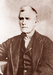
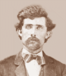
| Description | : | Michael was the 4th of 10 children of Jacob Rugh and Elizabeth Keppel of Westmoreland County, Pennsylvania. He was baptised April 26, 1818, at Greensburg 1st Lutheran Church. He married on March 17, 1842, Westmoreland County, Pennsylvania, to Zeruah "Ruey" Williams. Note the photo, courtesy of Phillip A. Knox, is believed to be Michael Rugh, but not identified with certainty. |
frequently asked questions (FAQ):
-
Where is Michael Rugh's memorial?
Michael Rugh's memorial is located at: Marham Cemetery, Marham, Kings Lynn and West Norfolk Borough, England.
-
When did Michael Rugh death?
Michael Rugh death on 1 Dec 1893 in Azen, Scotland County, Missouri, USA
-
Where are the coordinates of the Michael Rugh's memorial?
Latitude: 52.6622260
Longitude: 0.5287110
Family Members:
Parent
Spouse
Siblings
Children
Flowers:
Nearby Cemetories:
1. Marham Cemetery
Marham, Kings Lynn and West Norfolk Borough, England
Coordinate: 52.6622260, 0.5287110
2. Holy Trinity Churchyard
Marham, Kings Lynn and West Norfolk Borough, England
Coordinate: 52.6583800, 0.5236900
3. Pentney Priory
Pentney, Kings Lynn and West Norfolk Borough, England
Coordinate: 52.6803890, 0.5143830
4. Shouldham Priory
Shouldham, Kings Lynn and West Norfolk Borough, England
Coordinate: 52.6576070, 0.4836220
5. All Saints Churchyard
Shouldham, Kings Lynn and West Norfolk Borough, England
Coordinate: 52.6515690, 0.4837640
6. St. Mary Magdalene Churchyard
Pentney, Kings Lynn and West Norfolk Borough, England
Coordinate: 52.6950490, 0.5449550
7. St Martin's Churchyard
Fincham, Kings Lynn and West Norfolk Borough, England
Coordinate: 52.6296100, 0.4926900
8. St. Andrew's Churchyard
Barton Bendish, Kings Lynn and West Norfolk Borough, England
Coordinate: 52.6219270, 0.5277620
9. All Saints Churchyard
Narborough, Breckland Borough, England
Coordinate: 52.6861790, 0.5825420
10. St. Mary's Churchyard
Barton Bendish, Kings Lynn and West Norfolk Borough, England
Coordinate: 52.6198270, 0.5243860
11. St Cecilia's Churchyard
West Bilney, Kings Lynn and West Norfolk Borough, England
Coordinate: 52.7079810, 0.5395750
12. Blackborough Priory
Middleton, Kings Lynn and West Norfolk Borough, England
Coordinate: 52.6989000, 0.4749000
13. St. Botolph's Churchyard
Tottenhill, Kings Lynn and West Norfolk Borough, England
Coordinate: 52.6706000, 0.4433000
14. St. Mary the Virgin Churchyard
Beachamwell, Breckland Borough, England
Coordinate: 52.6178670, 0.5844730
15. All Saints Churchyard
East Winch, Kings Lynn and West Norfolk Borough, England
Coordinate: 52.7175790, 0.5025340
16. St. Mary's Churchyard
Narford, Breckland Borough, England
Coordinate: 52.6928740, 0.6095600
17. Saint Mary Churchyard
East Walton, Kings Lynn and West Norfolk Borough, England
Coordinate: 52.7146600, 0.5787130
18. St. Mary's Churchyard
Stradsett, Kings Lynn and West Norfolk Borough, England
Coordinate: 52.6178500, 0.4588500
19. St Mary's Churchyard
Middleton, Kings Lynn and West Norfolk Borough, England
Coordinate: 52.7162502, 0.4595386
20. Saint Andrew's Churchyard
South Runcton, Kings Lynn and West Norfolk Borough, England
Coordinate: 52.6472700, 0.4128500
21. All Saints Churchyard
Boughton, Kings Lynn and West Norfolk Borough, England
Coordinate: 52.5913020, 0.5080360
22. Exton Hall Roman Catholic Chapel
Exton, Rutland Unitary Authority, England
Coordinate: 52.6925000, 0.6382000
23. All Saints Churchyard
West Acre, Kings Lynn and West Norfolk Borough, England
Coordinate: 52.7055420, 0.6339660
24. All Saints Churchyard
North Runcton, Kings Lynn and West Norfolk Borough, England
Coordinate: 52.7155370, 0.4360180

