
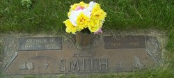
| Birth | : | 12 May 1905 State Center, Marshall County, Iowa, USA |
| Death | : | 8 Jul 1990 Letcher, Sanborn County, South Dakota, USA |
| Burial | : | Warwick General Cemetery, Warwick, Southern Downs Region, Australia |
| Coordinate | : | -28.2100890, 152.0044080 |
| Description | : | Graveside services were held Thursday, July 12, for Henry Smith, 87, of Letcher, SD, a former area resident who passed away Sunday, July 8 at his home. The Rev Marvin Flanscha of St John Lutheran Church, rural State Center, officiated. Burial was in St John's Cemetery. Mr Smith was born May 12, 1903 near State Center, attended St John's Parochial School. He was the son of William and Minnie Wolken Smth. He married Kathryn Hennis December 9, 1931 in State Center and they farmed in this area until moving to Letcher, SD. Surviving besides his wife,... Read More |
frequently asked questions (FAQ):
-
Where is Henry R Smith's memorial?
Henry R Smith's memorial is located at: Warwick General Cemetery, Warwick, Southern Downs Region, Australia.
-
When did Henry R Smith death?
Henry R Smith death on 8 Jul 1990 in Letcher, Sanborn County, South Dakota, USA
-
Where are the coordinates of the Henry R Smith's memorial?
Latitude: -28.2100890
Longitude: 152.0044080
Family Members:
Parent

Spouse
Siblings
Flowers:


Nearby Cemetories:
1. Warwick General Lawn Cemetery
Warwick, Southern Downs Region, Australia
Coordinate: -28.2106310, 152.0039087
2. Warwick War Cemetery
Warwick, Southern Downs Region, Australia
Coordinate: -28.2089620, 152.0033530
3. Eden Gardens Memorial Park
Warwick, Southern Downs Region, Australia
Coordinate: -28.2229690, 152.0031130
4. St Marks Anglican Church Columbarium Wall
Warwick, Southern Downs Region, Australia
Coordinate: -28.2161000, 152.0347600
5. Lone Grave Warwick
Warwick, Southern Downs Region, Australia
Coordinate: -28.2316590, 151.9833180
6. Warwick-Conway Family Homestead Cemetery
Warwick, Southern Downs Region, Australia
Coordinate: -28.1258400, 152.0395700
7. Swan Creek Anglican Cemetery
Swan Creek, Southern Downs Region, Australia
Coordinate: -28.1974400, 152.1364830
8. Glengallan Station
Warwick, Southern Downs Region, Australia
Coordinate: -28.1027016, 152.0585067
9. Yangan Presbyterian Church Cemetery
Yangan, Southern Downs Region, Australia
Coordinate: -28.1972310, 152.2142130
10. Yangan General and Anglican Cemetery
Emu Vale, Southern Downs Region, Australia
Coordinate: -28.2059990, 152.2207110
11. Allora Cemetery
Allora, Southern Downs Region, Australia
Coordinate: -28.0199230, 151.9750720
12. Pratten Cemetery
Pratten, Southern Downs Region, Australia
Coordinate: -28.0858450, 151.7790540
13. Dalveen-Mitchell Family Homestead Cemetery
Dalveen, Southern Downs Region, Australia
Coordinate: -28.4423200, 151.9604000
14. Maryvale Homestead Cemetery
Warwick, Southern Downs Region, Australia
Coordinate: -28.0669430, 152.2405230
15. Maryvale Cemetery
Maryvale, Southern Downs Region, Australia
Coordinate: -28.0607800, 152.2474610
16. Killarney Lawn Cemetery
Killarney, Southern Downs Region, Australia
Coordinate: -28.3475760, 152.2742790
17. Strath Elbess Cemetery
Dalveen, Southern Downs Region, Australia
Coordinate: -28.4883070, 151.9692850
18. Clifton General Cemetery
Clifton, Toowoomba Region, Australia
Coordinate: -27.9389150, 151.9120790
19. Headington Hill Lutheran Cemetery
Allora, Southern Downs Region, Australia
Coordinate: -27.9037210, 152.0020290
20. Back Plains Cemetery
Back Plains, Toowoomba Region, Australia
Coordinate: -27.9121770, 151.7970240
21. Spicers Gap
Boonah, Scenic Rim Region, Australia
Coordinate: -28.0733318, 152.4255524
22. Nobby Cemetery
Nobby, Toowoomba Region, Australia
Coordinate: -27.8322200, 151.8662000
23. Leyburn Cemetery
Leyburn, Southern Downs Region, Australia
Coordinate: -28.0085654, 151.5913366
24. Lone Grave Leyburn
Leyburn, Southern Downs Region, Australia
Coordinate: -28.0189540, 151.5842910