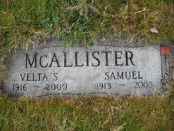
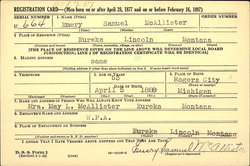
Henry Samuel “Sam” McAllister
| Birth | : | 1 Jun 1913 Kalispell, Flathead County, Montana, USA |
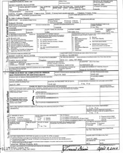
| Death | : | 5 Apr 2005 Libby, Lincoln County, Montana, USA |
| Burial | : | Pukerimu Lawn Cemetery, Paeroa, Hauraki District, New Zealand |
| Coordinate | : | -37.3900600, 175.6908910 |
| Description | : | LIBBY - Sam McAllister, 91, a longtime Libby-area logger, died Tuesday, April 5, 2005, at St. John Lutheran Hospital. He was born in Kalispell to Emery and Luella McAllister on June 1, 1913. Preceding him in death were his wife, Velta, in 2000; eight siblings; daughter, June Tholen; and four grandchildren. Survivors include his daughters, Evelyn Maxfield of Spokane and Carol McAllister and Judy Sauer, both of Libby; 13 grandchildren; 14 great-grandchildren; and 18 great-great-grandchildren. Visitation will be 3-8 p.m. Friday at the Nelson & Vial Funeral Home. Services will be 11 a.m. Saturday at Libby Christian Church followed by burial at the City of... Read More |
frequently asked questions (FAQ):
-
Where is Henry Samuel “Sam” McAllister's memorial?
Henry Samuel “Sam” McAllister's memorial is located at: Pukerimu Lawn Cemetery, Paeroa, Hauraki District, New Zealand.
-
When did Henry Samuel “Sam” McAllister death?
Henry Samuel “Sam” McAllister death on 5 Apr 2005 in Libby, Lincoln County, Montana, USA
-
Where are the coordinates of the Henry Samuel “Sam” McAllister's memorial?
Latitude: -37.3900600
Longitude: 175.6908910
Family Members:
Parent
Spouse
Siblings
Children
Nearby Cemetories:
1. Pukerimu Lawn Cemetery
Paeroa, Hauraki District, New Zealand
Coordinate: -37.3900600, 175.6908910
2. Tirohia
Paeroa, Hauraki District, New Zealand
Coordinate: -37.4381503, 175.6436459
3. Omahu Cemetery
Hikutaia, Thames-Coromandel District, New Zealand
Coordinate: -37.2707910, 175.6533300
4. Waihi Cemetery
Waihi, Hauraki District, New Zealand
Coordinate: -37.4093500, 175.8629600
5. Maukoro Cemetery
Morrinsville, Matamata-Piako District, New Zealand
Coordinate: -37.4614130, 175.5018220
6. Te Aroha Cemetery
Te Aroha, Matamata-Piako District, New Zealand
Coordinate: -37.5561450, 175.7109550
7. Ngatea Memorial Walls
Ngatea, Hauraki District, New Zealand
Coordinate: -37.2757990, 175.4915380
8. St Peters by the Sea
Waihi Beach, Western Bay of Plenty District, New Zealand
Coordinate: -37.4012045, 175.9369234
9. Whangamata Cemetery
Whangamata, Thames-Coromandel District, New Zealand
Coordinate: -37.2278330, 175.8553480
10. Tuapiro Cemetery
Katikati, Western Bay of Plenty District, New Zealand
Coordinate: -37.4987630, 175.9234740
11. Faulkner Urupā
Tauranga, Tauranga City, New Zealand
Coordinate: -37.4464650, 175.9540970
12. Totara Memorial Park
Thames, Thames-Coromandel District, New Zealand
Coordinate: -37.1653440, 175.5590990
13. Allan Block Cemetery
Whangamata, Thames-Coromandel District, New Zealand
Coordinate: -37.1794319, 175.8572147
14. Parawai Māori Cemetery
Parawai, Thames-Coromandel District, New Zealand
Coordinate: -37.1590100, 175.5640600
15. Katikati Cemetery
Katikati, Western Bay of Plenty District, New Zealand
Coordinate: -37.5824500, 175.9061600
16. Shortland Cemetery
Thames, Thames-Coromandel District, New Zealand
Coordinate: -37.1423500, 175.5571520
17. Piako Cemetery
Morrinsville, Matamata-Piako District, New Zealand
Coordinate: -37.6484900, 175.5412240
18. Morrinsville Old Cemetery
Morrinsville, Matamata-Piako District, New Zealand
Coordinate: -37.6531500, 175.5374260
19. Tararu Cemetery
Thames, Thames-Coromandel District, New Zealand
Coordinate: -37.1049590, 175.5189510
20. Makomako Urupā
Waitakaruru, Hauraki District, New Zealand
Coordinate: -37.2329470, 175.3389910
21. Waiterimu-Matahuru Cemetery
Waiterimu, Waikato District, New Zealand
Coordinate: -37.4452080, 175.2910660
22. Kaimai Flight 441 Air Crash Memorial
Gordon, Matamata-Piako District, New Zealand
Coordinate: -37.6960470, 175.8260440
23. Rukumoana Urupā
Matamata, Matamata-Piako District, New Zealand
Coordinate: -37.6976740, 175.5572500
24. Orini Cemetery
Orini, Waikato District, New Zealand
Coordinate: -37.5535200, 175.3222100


