
| Birth | : | 8 Oct 1929 Halbur, Carroll County, Iowa, USA |
| Death | : | 3 Feb 2019 Omaha, Douglas County, Nebraska, USA |
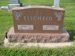
| Burial | : | Calvary Cemetery, Omaha, Douglas County, USA |
| Coordinate | : | 41.2364006, -96.0294037 |
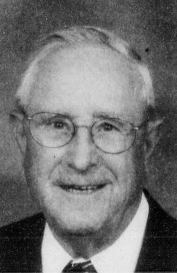
| Description | : | The son of Henry J. and Lucinda (Godert) Eischeid, Henry attended St. Augustine Grade School and Carroll High School. He entered the Air Force in 1950 during the Korean War and was honorably discharged as a Staff Sergeant in 1954. He and Florence Riesenberg were married on October 3, 1959 at Holy Angels Church in Roselle, Iowa. Before retiring in 1991, Mr. Eischeid had farmed for two years, served his country in the Air Force for four years, worked for John Deere in Waterloo, Iowa for three years, and was employed by AT&T... Read More |
frequently asked questions (FAQ):
-
Where is Henry T. “Hank” Eischeid's memorial?
Henry T. “Hank” Eischeid's memorial is located at: Calvary Cemetery, Omaha, Douglas County, USA.
-
When did Henry T. “Hank” Eischeid death?
Henry T. “Hank” Eischeid death on 3 Feb 2019 in Omaha, Douglas County, Nebraska, USA
-
Where are the coordinates of the Henry T. “Hank” Eischeid's memorial?
Latitude: 41.2364006
Longitude: -96.0294037
Family Members:
Parent

Spouse

Siblings
Flowers:


Nearby Cemetories:
1. Calvary Cemetery
Omaha, Douglas County, USA
Coordinate: 41.2364006, -96.0294037
2. Evergreen Memorial Park Cemetery
Omaha, Douglas County, USA
Coordinate: 41.2393990, -96.0355988
3. Resurrection Cemetery
Omaha, Douglas County, USA
Coordinate: 41.2344208, -96.0365448
4. Ak-Sar-Ben Racetrack Grounds
Omaha, Douglas County, USA
Coordinate: 41.2414703, -96.0159607
5. Saint Andrews Episcopal Church Columbarium
Omaha, Douglas County, USA
Coordinate: 41.2492500, -96.0427500
6. Countryside Community Church Columbarium
Omaha, Douglas County, USA
Coordinate: 41.2483660, -96.0500270
7. Westlawn-Hillcrest Memorial Park
Omaha, Douglas County, USA
Coordinate: 41.2346992, -95.9966965
8. Bohemian Cemetery
Omaha, Douglas County, USA
Coordinate: 41.2388992, -95.9955978
9. Beth El Cemetery
Ralston, Douglas County, USA
Coordinate: 41.2117004, -96.0428009
10. Holy Sepulchre Cemetery
Omaha, Douglas County, USA
Coordinate: 41.2543983, -95.9875031
11. Douglas County Poor Farm Cemetery
Omaha, Douglas County, USA
Coordinate: 41.2437240, -95.9723480
12. Graceland Park Cemetery
Omaha, Douglas County, USA
Coordinate: 41.2113991, -95.9785995
13. Saint Mary Magdalene Cemetery
Omaha, Douglas County, USA
Coordinate: 41.2039420, -95.9850610
14. All Saints Episcopal Church Columbarium
Omaha, Douglas County, USA
Coordinate: 41.2785000, -96.0579000
15. First Central Congregational Columbarium
Omaha, Douglas County, USA
Coordinate: 41.2563456, -95.9658365
16. Nash Chapel Crypt
Omaha, Douglas County, USA
Coordinate: 41.2665090, -95.9721790
17. Saint Mary's Cemetery
Omaha, Douglas County, USA
Coordinate: 41.2042007, -95.9646988
18. Papillion Cemetery
Papillion, Sarpy County, USA
Coordinate: 41.1758003, -96.0410995
19. Portal Cemetery
Sarpy County, USA
Coordinate: 41.1838989, -96.0802994
20. Servants of Mary Cemetery
Omaha, Douglas County, USA
Coordinate: 41.3017170, -96.0258260
21. Prospect Hill Cemetery
Omaha, Douglas County, USA
Coordinate: 41.2780991, -95.9593964
22. Mount Hope Cemetery
Omaha, Douglas County, USA
Coordinate: 41.3041992, -96.0310974
23. Saint Johns Cemetery
Bellevue, Sarpy County, USA
Coordinate: 41.1864014, -95.9682999
24. Pleasant Hill Cemetery
Omaha, Douglas County, USA
Coordinate: 41.2558975, -96.1194687