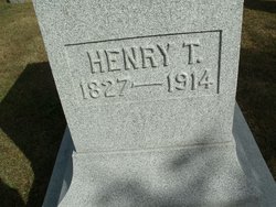
Henry Thornburg Bond
| Birth | : | 10 Feb 1827 Greens Fork, Wayne County, Indiana, USA |
| Death | : | 24 Mar 1914 Greens Fork, Wayne County, Indiana, USA |
| Burial | : | Hillside Memorial Park, Akron, Summit County, USA |
| Coordinate | : | 41.0387001, -81.4255981 |
| Plot | : | 45 |
| Description | : | Parents: Robert & Rachel (Thornburg) Bond Siblings: John, Emily, Milton, Abner Dalby, Lewis T., Lydia Ellen, Larkin T. Marriage Date: 4 September 1860 in Wayne County, Indiana Children: Robert Boyd, Emma Florence, James Edgar ======== *Published March 24, 1914 - New Castle Daily Courier, New Castle, IN HENRY T. BOND Word was received here this morning that Henry T. Bond, a pioneer Wayne county farmer, is dead at his home three miles south of Greensfork. Mr. Bond was the father-in-law of L. E. Kinsey, a former well known druggist of this city. He was also an uncle of Mrs. T. B. Millikan of this city. *Published... Read More |
frequently asked questions (FAQ):
-
Where is Henry Thornburg Bond's memorial?
Henry Thornburg Bond's memorial is located at: Hillside Memorial Park, Akron, Summit County, USA.
-
When did Henry Thornburg Bond death?
Henry Thornburg Bond death on 24 Mar 1914 in Greens Fork, Wayne County, Indiana, USA
-
Where are the coordinates of the Henry Thornburg Bond's memorial?
Latitude: 41.0387001
Longitude: -81.4255981
Family Members:
Spouse
Children
Flowers:
Nearby Cemetories:
1. Hillside Memorial Park
Akron, Summit County, USA
Coordinate: 41.0387001, -81.4255981
2. Grace Cathedral Cemetery
Akron, Summit County, USA
Coordinate: 41.0361958, -81.4297615
3. Ellet Cemetery
Akron, Summit County, USA
Coordinate: 41.0452995, -81.4360962
4. Maple Hill Cemetery
Akron, Summit County, USA
Coordinate: 41.0416527, -81.4056473
5. Memory Lane Cemetery
Ellet, Summit County, USA
Coordinate: 41.0495140, -81.4416990
6. Edwin Shaw Sanitarium Cemetery
South Akron, Summit County, USA
Coordinate: 41.0162010, -81.4332962
7. Greenwood Cemetery
Mogadore, Summit County, USA
Coordinate: 41.0518990, -81.3983002
8. Boosinger Cemetery
Tallmadge, Summit County, USA
Coordinate: 41.0677700, -81.4250000
9. Kent Corners Cemetery
Suffield, Portage County, USA
Coordinate: 41.0250000, -81.3831000
10. Old Springfield Cemetery
Akron, Summit County, USA
Coordinate: 41.0501780, -81.4722920
11. Milheim Cemetery
Millheim, Summit County, USA
Coordinate: 41.0018005, -81.4345016
12. Slovak Evangelical Cemetery
Krumroy, Summit County, USA
Coordinate: 41.0131989, -81.4675980
13. Saint Michaels Cemetery
Portage County, USA
Coordinate: 41.0518990, -81.3739014
14. Watson Park Vietnam Memory Garden
Akron, Summit County, USA
Coordinate: 41.0695100, -81.4627300
15. Tison Road Cemetery
Akron, Summit County, USA
Coordinate: 40.9995003, -81.3936996
16. East Akron Cemetery
Akron, Summit County, USA
Coordinate: 41.0681000, -81.4805984
17. Middlebury Cemetery
Akron, Summit County, USA
Coordinate: 41.0733986, -81.4784012
18. Pleasant Valley Cemetery
Akron, Summit County, USA
Coordinate: 41.0065002, -81.4931030
19. Greenlawn Cemetery
Uniontown, Stark County, USA
Coordinate: 40.9782982, -81.4103012
20. Tallmadge Cemetery
Tallmadge, Summit County, USA
Coordinate: 41.0989990, -81.4420013
21. East-Lawn Cemetery
Suffield, Portage County, USA
Coordinate: 41.0234200, -81.3453400
22. Old Lutheran Cemetery
Uniontown, Stark County, USA
Coordinate: 40.9772290, -81.4081710
23. Infirmary Cemetery
Tallmadge, Summit County, USA
Coordinate: 41.1003340, -81.4492790
24. First Congregational Churchyard
Tallmadge, Summit County, USA
Coordinate: 41.1018880, -81.4412870


