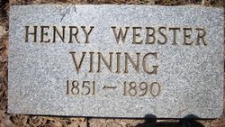
Henry Webster Vining
| Birth | : | 1851 |
| Death | : | 1890 |
| Burial | : | Memorial Park Cemetery, Enid, Garfield County, USA |
| Coordinate | : | 36.4585991, -97.8685989 |
| Description | : | Arkansas Marriages, 1820-1949 Name:Nancy A. Peeler Spouse:H. W. Vinnings Marriage Date:13 Jan 1870 County:Yell 1870 Gally Rock, Yell, ArkansasNameAgeHenry W Binnig 20 MS [Vining]Nancy Binnig 20 AR [Vining] |
frequently asked questions (FAQ):
-
Where is Henry Webster Vining's memorial?
Henry Webster Vining's memorial is located at: Memorial Park Cemetery, Enid, Garfield County, USA.
-
When did Henry Webster Vining death?
Henry Webster Vining death on 1890 in
-
Where are the coordinates of the Henry Webster Vining's memorial?
Latitude: 36.4585991
Longitude: -97.8685989
Family Members:
Spouse
Children
Flowers:
Left by Anonymous on 03 Apr 2011
the typed dates are wrong on this entry.Should read 1851 and 1890 according to the photo.Rest in Peace!
Left by Anonymous on 04 Apr 2014
Arkansas Marriages, 1820-1949 Name:Nancy A. Peeler Spouse:H. W. Vinnings Marriage Date:13 Jan 1870 County:Yell 1870 Gally Rock, Yell, ArkansasNameAgeHenry W Binnig 20 MS [Vining]Nancy Binnig 20 AR [Vining]
Left by Anonymous on 04 Apr 2014
Nearby Cemetories:
1. Memorial Park Cemetery
Enid, Garfield County, USA
Coordinate: 36.4585991, -97.8685989
2. Mennonite Brethren Cemetery
Enid, Garfield County, USA
Coordinate: 36.4637900, -97.8605300
3. Enid State School Cemetery
Enid, Garfield County, USA
Coordinate: 36.4326900, -97.8370800
4. Calvary Catholic Cemetery
Enid, Garfield County, USA
Coordinate: 36.4200900, -97.8789800
5. Enid Cemetery
Enid, Garfield County, USA
Coordinate: 36.4199295, -97.8803329
6. Banner Hill Cemetery
Garfield County, USA
Coordinate: 36.4627500, -97.9425300
7. Chisholm Trail Burial Park
Enid, Garfield County, USA
Coordinate: 36.4632500, -97.7921900
8. Saint Matthews Episcopal Church Columbarium
Enid, Garfield County, USA
Coordinate: 36.3980590, -97.8847090
9. First United Methodist Church Columbarium
Enid, Garfield County, USA
Coordinate: 36.3976370, -97.8837560
10. Breckinridge Lutheran Cemetery
Breckinridge, Garfield County, USA
Coordinate: 36.4632988, -97.7474976
11. Kremlin Cemetery
Kremlin, Garfield County, USA
Coordinate: 36.5494003, -97.8131027
12. Bethany Cemetery
Enid, Garfield County, USA
Coordinate: 36.3619003, -97.8097000
13. Rose Hill Cemetery
Carrier, Garfield County, USA
Coordinate: 36.4782753, -98.0322952
14. Hillsdale Cemetery
Hillsdale, Garfield County, USA
Coordinate: 36.5652800, -97.9701700
15. Paradise Cemetery
Breckinridge, Garfield County, USA
Coordinate: 36.4336014, -97.7018967
16. Trinity Lutheran Cemetery
Enid, Garfield County, USA
Coordinate: 36.4195300, -98.0342500
17. Zion Lutheran Cemetery
Fairmont, Garfield County, USA
Coordinate: 36.3749400, -97.7297400
18. Valley Center Cemetery
Pond Creek, Grant County, USA
Coordinate: 36.6081009, -97.8281021
19. Collett Cemetery
Fairmont, Garfield County, USA
Coordinate: 36.3683014, -97.7102966
20. Sunnyside Cemetery
Lahoma, Garfield County, USA
Coordinate: 36.3692017, -98.0500031
21. Baumagartner Cemetery
Lahoma, Garfield County, USA
Coordinate: 36.4194700, -98.0779100
22. Imo Cemetery
Drummond, Garfield County, USA
Coordinate: 36.3293991, -98.0156021
23. Hackberry Cemetery
Garfield County, USA
Coordinate: 36.2822500, -97.8362700
24. Lahoma Mennonite Cemetery
Lahoma, Garfield County, USA
Coordinate: 36.4256400, -98.0864800


