
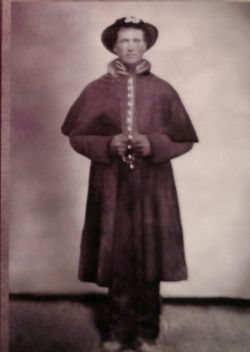
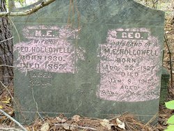
Hensley Hollowell
| Birth | : | 1835 Benton County, Tennessee, USA |
| Death | : | 1874 Rector, Clay County, Arkansas, USA |
| Burial | : | Woodland Heights Cemetery, Rector, Clay County, USA |
| Coordinate | : | 36.2724991, -90.3039017 |
| Plot | : | Unmarked Grave |
| Description | : | Husband of Sarah H Tate (m. 12/27/1855) Private, Company D, 7th Tennessee Cavalry, enlisted in Carroll Co, TN on 8/14/1862. He was captured and paroled with the regiment at the battle of Trenton on 12/20/1862. He served out his one year enlistment and mustered out at Saulsbury, TN on 10/25/1863. He was the son of Reddin and Jane Hollowell and brother to Stephen Hollowell (Hallowell) of Co D. Holley, Peggy Scott. Hawkins' Tories, A Regimental and Social History of the 7th Tennessee Cavalry USA in the Civil War, BrayBree Publishing, Dickson TN, 230 p, 2014 |
frequently asked questions (FAQ):
-
Where is Hensley Hollowell's memorial?
Hensley Hollowell's memorial is located at: Woodland Heights Cemetery, Rector, Clay County, USA.
-
When did Hensley Hollowell death?
Hensley Hollowell death on 1874 in Rector, Clay County, Arkansas, USA
-
Where are the coordinates of the Hensley Hollowell's memorial?
Latitude: 36.2724991
Longitude: -90.3039017
Family Members:
Parent
Spouse
Siblings

Children
Flowers:


Nearby Cemetories:
1. Woodland Heights Cemetery
Rector, Clay County, USA
Coordinate: 36.2724991, -90.3039017
2. Scatterville Cemetery
Rector, Clay County, USA
Coordinate: 36.2813683, -90.3131104
3. Parks Cemetery
Rector, Clay County, USA
Coordinate: 36.2619934, -90.3266754
4. Marys Chapel Cemetery
Rector, Clay County, USA
Coordinate: 36.2921982, -90.2830963
5. Mound Cemetery
Clay County, USA
Coordinate: 36.2737312, -90.3426285
6. Hillsboro Cemetery
Rector, Clay County, USA
Coordinate: 36.2975883, -90.2605820
7. Blooming Grove Cemetery
Clay County, USA
Coordinate: 36.3147011, -90.2913971
8. Pleasant Grove Cemetery
Hopewell, Greene County, USA
Coordinate: 36.2543983, -90.3630981
9. Ebenezer Cemetery
Clay County, USA
Coordinate: 36.2887383, -90.3643570
10. Shannon Cemetery
Clay County, USA
Coordinate: 36.2982483, -90.3639374
11. Liberty Hill Cemetery
Boydsville, Clay County, USA
Coordinate: 36.3280983, -90.3182983
12. Hargrave Parish Church
Hargrave Corner, Clay County, USA
Coordinate: 36.2590598, -90.2290688
13. Lone Grave
Clay County, USA
Coordinate: 36.3358002, -90.3331070
14. Travillian Cemetery
Clay County, USA
Coordinate: 36.3382988, -90.2842026
15. Purcell Cemetery
Rector, Clay County, USA
Coordinate: 36.2602997, -90.3910980
16. Leonard Cemetery
Leonard, Clay County, USA
Coordinate: 36.2164001, -90.2481003
17. Johnson Chapel Cemetery
Clay County, USA
Coordinate: 36.3383900, -90.3572400
18. Salem Cemetery
Rector, Clay County, USA
Coordinate: 36.3208008, -90.3818970
19. Mitchell Cemetery
Greenway, Clay County, USA
Coordinate: 36.3352013, -90.2378464
20. Cudd Cemetery
Marmaduke, Greene County, USA
Coordinate: 36.2202988, -90.3955994
21. Winston Cemetery
Clay County, USA
Coordinate: 36.3464012, -90.2382965
22. Harveys Chapel Cemetery
Marmaduke, Greene County, USA
Coordinate: 36.2131004, -90.3906021
23. Mars Hill Cemetery
Crockett, Clay County, USA
Coordinate: 36.3624992, -90.3275604
24. Underwood Cemetery
Clay County, USA
Coordinate: 36.3656006, -90.2639008