
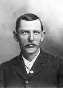
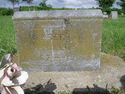
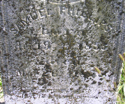
Herbert Rice Phillips
| Birth | : | 7 Dec 1867 Bone Gap, Edwards County, Illinois, USA |
| Death | : | 11 Oct 1907 Diamond Springs, Morris County, Kansas, USA |
| Burial | : | St Thomas à Becket's Church, Widcombe, Bath and North East Somerset Unitary Authority, England |
| Coordinate | : | 51.3734250, -2.3465560 |
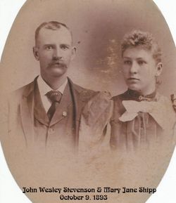
| Description | : | Herbert Rice Phillips was born December 7th, 1867 in Bone Gap, Edwards Co, Illinois, the youngest child of Elijah and Roana Rice Phillips. The family moved to Diamond Springs, KS in 1868 when Herbert was just a baby. Herbert grew up in the Diamond Springs area where he was married in 1899 to Mary Jane ("Molly") Shipp Stevenson, widow of Roy Stevenson and mother of 2 small children, Hazel and Roy Stevenson. After their marriage, Herbert and Molly became the parents of 2 more children, Frank E. Phillips born in 1900, and Ruth Alice Phillips born 1903. ... Read More |
frequently asked questions (FAQ):
-
Where is Herbert Rice Phillips's memorial?
Herbert Rice Phillips's memorial is located at: St Thomas à Becket's Church, Widcombe, Bath and North East Somerset Unitary Authority, England.
-
When did Herbert Rice Phillips death?
Herbert Rice Phillips death on 11 Oct 1907 in Diamond Springs, Morris County, Kansas, USA
-
Where are the coordinates of the Herbert Rice Phillips's memorial?
Latitude: 51.3734250
Longitude: -2.3465560
Family Members:
Parent

Spouse
Siblings

Children
Flowers:


Nearby Cemetories:
1. St Thomas à Becket's Church
Widcombe, Bath and North East Somerset Unitary Authority, England
Coordinate: 51.3734250, -2.3465560
2. Quaker Burial Ground
Widcombe, Bath and North East Somerset Unitary Authority, England
Coordinate: 51.3744350, -2.3498460
3. Bath Abbey Cemetery
Widcombe, Bath and North East Somerset Unitary Authority, England
Coordinate: 51.3712850, -2.3483060
4. Smallcombe Vale Cemetery
Bathwick, Bath and North East Somerset Unitary Authority, England
Coordinate: 51.3757400, -2.3429400
5. St John the Evangelist Cemetery
Bath, Bath and North East Somerset Unitary Authority, England
Coordinate: 51.3696700, -2.3487400
6. St. Mary The Virgin Churchyard
Bathwick, Bath and North East Somerset Unitary Authority, England
Coordinate: 51.3759930, -2.3411930
7. Old Baptist Burial Ground
Walcot, Bath and North East Somerset Unitary Authority, England
Coordinate: 51.3755070, -2.3544360
8. Abbey & St James' Graveyard for the Poor
Widcombe, Bath and North East Somerset Unitary Authority, England
Coordinate: 51.3753550, -2.3545640
9. Unitarian Chapel Burial Ground
Widcombe, Bath and North East Somerset Unitary Authority, England
Coordinate: 51.3704650, -2.3539270
10. Baptist Burial Ground
Widcombe, Bath and North East Somerset Unitary Authority, England
Coordinate: 51.3764216, -2.3556947
11. Saint Mark's Churchyard
Widcombe, Bath and North East Somerset Unitary Authority, England
Coordinate: 51.3766660, -2.3588010
12. Prior Park College
Bath, Bath and North East Somerset Unitary Authority, England
Coordinate: 51.3645990, -2.3442400
13. Old Orchard Street Catholic Burial Vault
Bath, Bath and North East Somerset Unitary Authority, England
Coordinate: 51.3800370, -2.3579910
14. St James Old Burial Ground
Bath, Bath and North East Somerset Unitary Authority, England
Coordinate: 51.3798600, -2.3610100
15. Bath Abbey
Bath, Bath and North East Somerset Unitary Authority, England
Coordinate: 51.3815310, -2.3586640
16. St Mary Magdalen Chapel
Widcombe, Bath and North East Somerset Unitary Authority, England
Coordinate: 51.3760486, -2.3643405
17. St. Mary de Stall Churchyard (Defunct)
Bath, Bath and North East Somerset Unitary Authority, England
Coordinate: 51.3813350, -2.3600353
18. Quaker Meeting House
Bath, Bath and North East Somerset Unitary Authority, England
Coordinate: 51.3823280, -2.3604380
19. Bath General Hospital Burial Ground
Bath and North East Somerset Unitary Authority, England
Coordinate: 51.3824715, -2.3614742
20. Ss Michael & Paul Churchyard
Bath, Bath and North East Somerset Unitary Authority, England
Coordinate: 51.3834970, -2.3596980
21. St. Michael's Burial Ground
Bath, Bath and North East Somerset Unitary Authority, England
Coordinate: 51.3838810, -2.3594090
22. Union Chapel
Combe Down, Bath and North East Somerset Unitary Authority, England
Coordinate: 51.3594751, -2.3443662
23. Jewish Burial Ground
Combe Down, Bath and North East Somerset Unitary Authority, England
Coordinate: 51.3599170, -2.3534670
24. St Mary's Chapel, Queens Square
Bath, Bath and North East Somerset Unitary Authority, England
Coordinate: 51.3827790, -2.3649790