
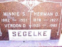
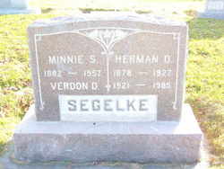
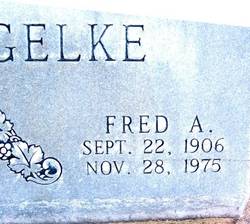
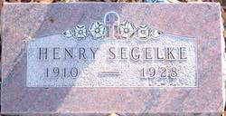
Hermann Dietrich Segelke
| Birth | : | 10 Apr 1878 Germany |
| Death | : | 7 Apr 1927 Gurley, Cheyenne County, Nebraska, USA |
| Burial | : | Bethel Cemetery, Osterdock, Clayton County, USA |
| Coordinate | : | 42.7041702, -91.1688919 |
frequently asked questions (FAQ):
-
Where is Hermann Dietrich Segelke's memorial?
Hermann Dietrich Segelke's memorial is located at: Bethel Cemetery, Osterdock, Clayton County, USA.
-
When did Hermann Dietrich Segelke death?
Hermann Dietrich Segelke death on 7 Apr 1927 in Gurley, Cheyenne County, Nebraska, USA
-
Where are the coordinates of the Hermann Dietrich Segelke's memorial?
Latitude: 42.7041702
Longitude: -91.1688919
Family Members:
Spouse
Children

Flowers:


Nearby Cemetories:
1. Bethel Cemetery
Osterdock, Clayton County, USA
Coordinate: 42.7041702, -91.1688919
2. Bolsinger Cemetery
Mallory Township, Clayton County, USA
Coordinate: 42.6776340, -91.1424090
3. Noggle Cemetery
Clayton County, USA
Coordinate: 42.6666580, -91.1654100
4. Lewis Cemetery
Osterdock, Clayton County, USA
Coordinate: 42.7416000, -91.1834000
5. Graham Cemetery
Millville, Clayton County, USA
Coordinate: 42.6833172, -91.1195685
6. Friedlein Cemetery
Millville, Clayton County, USA
Coordinate: 42.7080994, -91.1108017
7. Hansel Cemetery
Mallory Township, Clayton County, USA
Coordinate: 42.7066994, -91.2433014
8. Brown Cemetery
Mallory Township, Clayton County, USA
Coordinate: 42.6530991, -91.2005997
9. Bierer Cemetery
Millville, Clayton County, USA
Coordinate: 42.7230500, -91.0925166
10. Saint Johns Cemetery
Jefferson Township, Clayton County, USA
Coordinate: 42.7497000, -91.1133000
11. Redman Cemetery
Millville, Clayton County, USA
Coordinate: 42.7166755, -91.0852901
12. Saint Paula Cemetery
Osterdock, Clayton County, USA
Coordinate: 42.7635994, -91.1992035
13. Storck Cemetery
Guttenberg, Clayton County, USA
Coordinate: 42.7694335, -91.1834638
14. Oak Hill Cemetery
Colesburg, Delaware County, USA
Coordinate: 42.6391983, -91.1924973
15. Saint Marys Cemetery
Guttenberg, Clayton County, USA
Coordinate: 42.7691994, -91.1352997
16. Guttenberg Cemetery
Guttenberg, Clayton County, USA
Coordinate: 42.7691994, -91.1035995
17. Saint Patricks Cemetery
Colesburg, Delaware County, USA
Coordinate: 42.6241989, -91.1928024
18. Mount Harmony Cemetery
Elkport, Clayton County, USA
Coordinate: 42.7181015, -91.2799988
19. Old Garber Cemetery
Garber, Clayton County, USA
Coordinate: 42.7560005, -91.2580032
20. Mount Olivet Cemetery
Guttenberg, Clayton County, USA
Coordinate: 42.7764840, -91.1083560
21. Goshen Cemetery
Millville, Clayton County, USA
Coordinate: 42.6905594, -91.0544434
22. Immanuel Lutheran Cemetery
Elkport, Clayton County, USA
Coordinate: 42.7433014, -91.2733002
23. Saint Michaels Cemetery
Elkport, Clayton County, USA
Coordinate: 42.7433014, -91.2733002
24. Zion Cemetery
Colesburg, Delaware County, USA
Coordinate: 42.6380997, -91.2493973