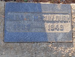
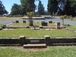
Hilda Othelia Nierhoff McCullough
| Birth | : | 5 Apr 1899 California, USA |
| Death | : | 29 Jul 1949 Placer County, California, USA |
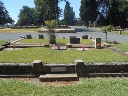
| Burial | : | Waikumete Cemetery & Crematorium, Glen Eden, Auckland Council, New Zealand |
| Coordinate | : | -36.9025130, 174.6539610 |
| Plot | : | E 1/2 493 |
| Description | : | McCullough Irish (especially Ulster): Anglicized form of the Gaelic surname Mac Cú Uladh, a patronymic from Cú Uladh ‘hound of Ulster'. Compare McNally, which is from Mac Con Uladh, genitive form of the same name. It has sometimes been erroneously associated with Gaelic cullach ‘wild boar', and some families in County Sligo have translated it into English as Boar. Dictionary of American Family Names, Oxford University Press |
frequently asked questions (FAQ):
-
Where is Hilda Othelia Nierhoff McCullough's memorial?
Hilda Othelia Nierhoff McCullough's memorial is located at: Waikumete Cemetery & Crematorium, Glen Eden, Auckland Council, New Zealand.
-
When did Hilda Othelia Nierhoff McCullough death?
Hilda Othelia Nierhoff McCullough death on 29 Jul 1949 in Placer County, California, USA
-
Where are the coordinates of the Hilda Othelia Nierhoff McCullough's memorial?
Latitude: -36.9025130
Longitude: 174.6539610
Family Members:
Parent
Spouse
Siblings
Children
Nearby Cemetories:
1. Waikumete Cemetery & Crematorium
Glen Eden, Auckland Council, New Zealand
Coordinate: -36.9025130, 174.6539610
2. Auckland Provincial Memorial
Glen Eden, Auckland Council, New Zealand
Coordinate: -36.9020700, 174.6548500
3. Oratia Cemetery
Oratia, Auckland Council, New Zealand
Coordinate: -36.9108800, 174.6218900
4. Settlers Cemetery
Oratia, Auckland Council, New Zealand
Coordinate: -36.9108770, 174.6218870
5. George Maxwell Memorial Cemetery
Avondale, Auckland Council, New Zealand
Coordinate: -36.8890320, 174.6849320
6. Saint Ninians Churchyard
Avondale, Auckland Council, New Zealand
Coordinate: -36.8994510, 174.6966690
7. Oratia Combined Church Cemetery
Oratia, Auckland Council, New Zealand
Coordinate: -36.9196396, 174.6119362
8. Swanson Cemetery
Swanson, Auckland Council, New Zealand
Coordinate: -36.8718400, 174.5836200
9. St. Luke's Anglican Church Cemetery
Mount Albert, Auckland Council, New Zealand
Coordinate: -36.8785540, 174.7290400
10. Hillsborough Cemetery
Hillsborough, Auckland Council, New Zealand
Coordinate: -36.9246600, 174.7524030
11. Saint Andrew's Churchyard
Epsom, Auckland Council, New Zealand
Coordinate: -36.8937200, 174.7654100
12. Mount Eden Stockade Cemetery
Mount Eden, Auckland Council, New Zealand
Coordinate: -36.8678370, 174.7666430
13. Symonds Street Cemetery
Auckland, Auckland Council, New Zealand
Coordinate: -36.8582828, 174.7636628
14. Hobsonville Church and Settlers' Cemetery
Hobsonville, Auckland Council, New Zealand
Coordinate: -36.8000500, 174.6551800
15. St Mark's Anglican Church Cemetery
Remuera, Auckland Council, New Zealand
Coordinate: -36.8729300, 174.7801600
16. St. Peter's Anglican Cemetery
Ōnehunga, Auckland Council, New Zealand
Coordinate: -36.9227113, 174.7847550
17. Our Lady of the Assumption Catholic Church
Ōnehunga, Auckland Council, New Zealand
Coordinate: -36.9223690, 174.7884530
18. Onehunga Catholic Cemetery
Ōnehunga, Auckland Council, New Zealand
Coordinate: -36.9224360, 174.7884560
19. Mangere Piriti Urupā St. James Churchyard
Mangere, Auckland Council, New Zealand
Coordinate: -36.9418970, 174.7835260
20. Pompallier Cemetery
Birkenhead, Auckland Council, New Zealand
Coordinate: -36.8036900, 174.7251200
21. Waikaraka Cemetery
Ōnehunga, Auckland Council, New Zealand
Coordinate: -36.9297140, 174.7967170
22. Birkenhead-Glenfield Cemetery
Birkenhead, Auckland Council, New Zealand
Coordinate: -36.7989000, 174.7234700
23. St. Stephen's Churchyard
Auckland, Auckland Council, New Zealand
Coordinate: -36.8504860, 174.7899970
24. Mangere Lawn Cemetery
Mangere, Auckland Council, New Zealand
Coordinate: -36.9626150, 174.7857000

