
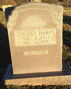
Hiram Tinsley Harpe
| Birth | : | 8 Aug 1911 Clay County, Tennessee, USA |
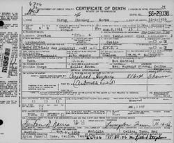
| Death | : | 4 Nov 1956 Livingston, Overton County, Tennessee, USA |
| Burial | : | McColgan Cemetery, Clay County, USA |
| Coordinate | : | 36.5163994, -85.5560989 |
| Description | : | Tinsley died from injuries sustained in an automobile accident. He was an auto mechanic in Celina. |
frequently asked questions (FAQ):
-
Where is Hiram Tinsley Harpe's memorial?
Hiram Tinsley Harpe's memorial is located at: McColgan Cemetery, Clay County, USA.
-
When did Hiram Tinsley Harpe death?
Hiram Tinsley Harpe death on 4 Nov 1956 in Livingston, Overton County, Tennessee, USA
-
Where are the coordinates of the Hiram Tinsley Harpe's memorial?
Latitude: 36.5163994
Longitude: -85.5560989
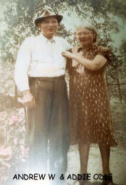
Family Members:
Parent
Siblings
Flowers:


Nearby Cemetories:
1. McColgan Cemetery
Clay County, USA
Coordinate: 36.5163994, -85.5560989
2. Lester Brown Family Cemetery
Arcott, Clay County, USA
Coordinate: 36.5205700, -85.5547530
3. Mabry Cemetery
Clay County, USA
Coordinate: 36.5139008, -85.5464020
4. Archibald Plumlee Cemetery
Pine Hill, Clay County, USA
Coordinate: 36.5203018, -85.5682983
5. Roberts Cemetery
Celina, Clay County, USA
Coordinate: 36.5066986, -85.5727997
6. Hamilton Cemetery
Clay County, USA
Coordinate: 36.5181007, -85.5338974
7. Kirk Cemetery
Clay County, USA
Coordinate: 36.4960670, -85.5661650
8. Butlers Landing Cemetery
Celina, Clay County, USA
Coordinate: 36.4941300, -85.5600410
9. Doc Hall Cemetery
Clay County, USA
Coordinate: 36.4995390, -85.5369270
10. Hall Cemetery
Clay County, USA
Coordinate: 36.4994011, -85.5366974
11. John Hamilton Cemetery
Butlers Landing, Clay County, USA
Coordinate: 36.4916010, -85.5489080
12. Dalton Cemetery
Arcott, Clay County, USA
Coordinate: 36.5429540, -85.5546170
13. Emberton Cemetery
Celina, Clay County, USA
Coordinate: 36.4862150, -85.5237040
14. John Fowler Cemetery
Butlers Landing, Clay County, USA
Coordinate: 36.4910900, -85.5972590
15. McDonald Cemetery
Baptist Ridge, Clay County, USA
Coordinate: 36.4855995, -85.5119019
16. High Cedar Cemetery
Clay County, USA
Coordinate: 36.4827710, -85.5974970
17. M R Cemetery
Baptist Ridge, Clay County, USA
Coordinate: 36.4769100, -85.5196770
18. Rich-Lynn Family Cemetery
Butlers Landing, Clay County, USA
Coordinate: 36.4794140, -85.5987380
19. Amos Kirkpatrick-Tinsley Cemetery
Jackson County, USA
Coordinate: 36.4715080, -85.5867230
20. Varney Andrews Cemetery
Celina, Clay County, USA
Coordinate: 36.5604650, -85.5209530
21. Green Cemetery
Celina, Clay County, USA
Coordinate: 36.5496418, -85.5024450
22. Plumlee Cemetery
Celina, Clay County, USA
Coordinate: 36.5694280, -85.5282830
23. Goolsby Cemetery
Clay County, USA
Coordinate: 36.4603640, -85.5368040
24. Walker Reecer Cemetery
Celina, Clay County, USA
Coordinate: 36.5746290, -85.5480270