Homer Coffey
| Birth | : | 25 Mar 1902 |
| Death | : | 6 Sep 1976 |
| Burial | : | All Saints Churchyard, Laxfield, Mid Suffolk District, England |
| Coordinate | : | 52.3020950, 1.3663410 |
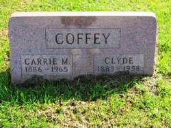
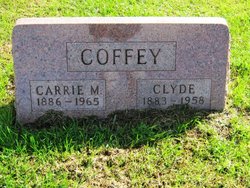
| Description | : | Homer Coffey, son of Clyde and Carrie Mae Abel was born Mar. 25, 1902, south of Humeston, and passed away Sept. 6, 1976 at the age of 74 years, 5 months and eleven days. On Dec. 24, 1922, he was united in marriage to Helen Muse. To this union two children were born, a son, Billy Watson, and a daughter Rita Colleen. Homer was an active member of the First Baptist Church of Humeston until health prevented his attendance. He farmed all his life in and around the Humeston and Cambria area. |
frequently asked questions (FAQ):
-
Where is Homer Coffey's memorial?
Homer Coffey's memorial is located at: All Saints Churchyard, Laxfield, Mid Suffolk District, England.
-
When did Homer Coffey death?
Homer Coffey death on 6 Sep 1976 in
-
Where are the coordinates of the Homer Coffey's memorial?
Latitude: 52.3020950
Longitude: 1.3663410
Family Members:
Parent
Spouse
Siblings
Children
Flowers:
Nearby Cemetories:
1. All Saints Churchyard
Laxfield, Mid Suffolk District, England
Coordinate: 52.3020950, 1.3663410
2. Baptist's Church Burial Ground
Laxfield, Mid Suffolk District, England
Coordinate: 52.3015500, 1.3627300
3. Laxfield Cemetery
Laxfield, Mid Suffolk District, England
Coordinate: 52.3022920, 1.3575990
4. St. Peter's Churchyard
Ubbeston, Suffolk Coastal District, England
Coordinate: 52.3021220, 1.4062940
5. Saint Mary's Churchyard
Cratfield, Suffolk Coastal District, England
Coordinate: 52.3227330, 1.3940450
6. St Margaret Churchyard
Heveningham, Suffolk Coastal District, England
Coordinate: 52.3017670, 1.4209263
7. St Lawrence Churchyard
Brundish, Mid Suffolk District, England
Coordinate: 52.2771070, 1.3283390
8. St John the Baptist Churchyard
Badingham, Suffolk Coastal District, England
Coordinate: 52.2647040, 1.3770250
9. St. Mary The Virgin Churchyard
Huntingfield, Suffolk Coastal District, England
Coordinate: 52.3170350, 1.4263510
10. Fressingfield Cemetery
Fressingfield, Mid Suffolk District, England
Coordinate: 52.3392240, 1.3135440
11. St. Mary the Virgin Churchyard
Dennington, Suffolk Coastal District, England
Coordinate: 52.2534740, 1.3412550
12. Stradbroke Cemetery
Stradbroke, Mid Suffolk District, England
Coordinate: 52.3187700, 1.2831900
13. Baptist Churchyard
Fressingfield, Mid Suffolk District, England
Coordinate: 52.3481570, 1.3216200
14. St Michael and All Angels Churchyard
Cookley, Suffolk Coastal District, England
Coordinate: 52.3258980, 1.4466090
15. St. Peter and St. Paul Churchyard
Fressingfield, Mid Suffolk District, England
Coordinate: 52.3487940, 1.3190390
16. Fressingfield Methodist Churchyard
Fressingfield, Mid Suffolk District, England
Coordinate: 52.3472430, 1.3133970
17. All Saints Churchyard
Stradbroke, Mid Suffolk District, England
Coordinate: 52.3186110, 1.2733720
18. Peasenhall Cemetery
Peasenhall, Suffolk Coastal District, England
Coordinate: 52.2693020, 1.4474450
19. St. Margaret's Churchyard of Antioch
Linstead Parva, Suffolk Coastal District, England
Coordinate: 52.3477630, 1.4302960
20. St Michael Churchyard
Peasenhall, Suffolk Coastal District, England
Coordinate: 52.2706000, 1.4509580
21. St. Peter's Churchyard
Bruisyard, Suffolk Coastal District, England
Coordinate: 52.2453720, 1.4044820
22. St Ethelbert Churchyard
Tannington, Mid Suffolk District, England
Coordinate: 52.2597880, 1.2846630
23. Metfield Cemetery
Metfield, Mid Suffolk District, England
Coordinate: 52.3678410, 1.3635810
24. All Saints Churchyard
Saxtead, Suffolk Coastal District, England
Coordinate: 52.2433040, 1.3125269


