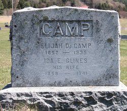
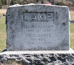
Ida Estelle Glines Camp
| Birth | : | 1 Jun 1858 Tunbridge, Orange County, Vermont, USA |
| Death | : | 8 May 1941 East Randolph, Orange County, Vermont, USA |
| Burial | : | Mount Zion Cemetery, Mosby, Clay County, USA |
| Coordinate | : | 39.2881012, -94.3052979 |
| Description | : | Daughter of Moses Glines and Hannah Grant. |
frequently asked questions (FAQ):
-
Where is Ida Estelle Glines Camp's memorial?
Ida Estelle Glines Camp's memorial is located at: Mount Zion Cemetery, Mosby, Clay County, USA.
-
When did Ida Estelle Glines Camp death?
Ida Estelle Glines Camp death on 8 May 1941 in East Randolph, Orange County, Vermont, USA
-
Where are the coordinates of the Ida Estelle Glines Camp's memorial?
Latitude: 39.2881012
Longitude: -94.3052979
Family Members:
Parent
Spouse
Siblings
Children
Flowers:
Nearby Cemetories:
1. Mount Zion Cemetery
Mosby, Clay County, USA
Coordinate: 39.2881012, -94.3052979
2. Woodland Cemetery
Mosby, Clay County, USA
Coordinate: 39.2928009, -94.2960968
3. Baldwin Cemetery
Excelsior Springs, Clay County, USA
Coordinate: 39.2956009, -94.3197021
4. Buxton Cemetery
Prathersville, Clay County, USA
Coordinate: 39.2780991, -94.2919006
5. Cameron Cemetery
Clay County, USA
Coordinate: 39.2743988, -94.3182983
6. George Cemetery
Clay County, USA
Coordinate: 39.2700005, -94.3052979
7. Hodges Graveyard
Clay County, USA
Coordinate: 39.2883500, -94.3374900
8. Means Cemetery
Clay County, USA
Coordinate: 39.2921982, -94.3419037
9. Scott Cemetery
Clay County, USA
Coordinate: 39.2708015, -94.2538986
10. McQuiddy Family Cemetery
Liberty, Clay County, USA
Coordinate: 39.2639000, -94.3519000
11. Munkirs Cemetery
Mosby, Clay County, USA
Coordinate: 39.3246994, -94.3371964
12. Moore Cemetery
Excelsior Springs, Clay County, USA
Coordinate: 39.2696991, -94.2530975
13. Missouri City Cemetery
Missouri City, Clay County, USA
Coordinate: 39.2417297, -94.2970734
14. Welton Cemetery
Clay County, USA
Coordinate: 39.3292800, -94.2663300
15. McKee-Moore Cemetery
Clay County, USA
Coordinate: 39.3315630, -94.2608620
16. Hillcrest Cemetery
Excelsior Springs, Clay County, USA
Coordinate: 39.3358002, -94.2619019
17. Clay County Cemetery
Chandler, Clay County, USA
Coordinate: 39.3072300, -94.3776000
18. Chandler Church Cemetery
Chandler, Clay County, USA
Coordinate: 39.2986412, -94.3818207
19. Old Liberty Cemetery
Kearney, Clay County, USA
Coordinate: 39.3246994, -94.3700027
20. Keller Cemetery
Clay County, USA
Coordinate: 39.2415200, -94.3627900
21. Elmwood Cemetery
Excelsior Springs, Clay County, USA
Coordinate: 39.3353004, -94.2485962
22. Enon Cemetery
Excelsior Springs, Clay County, USA
Coordinate: 39.2958984, -94.2221985
23. Elitzer Cemetery
Miltondale, Clay County, USA
Coordinate: 39.2595640, -94.2289210
24. Tapp Cemetery
Kearney, Clay County, USA
Coordinate: 39.3342000, -94.3669000


