

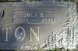
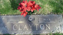
Iola Bernice Reynolds Clayton
| Birth | : | 26 Jul 1917 Hysham, Treasure County, Montana, USA |
| Death | : | 1 Apr 1991 Fairfield, Solano County, California, USA |
| Burial | : | Taruheru Cemetery, Gisborne, Gisborne District, New Zealand |
| Coordinate | : | -38.6428900, 177.9802300 |
| Description | : | Iola was born the only girl among six boys. Five brothers were older, including Lewis 'Louie'. At least three of her brothers are known to have died in CA. She remained in NE until the late 30's or early 40's. By 1943, she had met Russell Clayton, when they were married in Oakland. According to her daughter, there were two brothers besides Barbara. One of Barbara's nieces continued Barbara's research in family history. Although, Iola lived much of her life in CA, her friends and family in NE will remember her through the Dixon M. E. Ladies Aid cookbook, especial her... Read More |
frequently asked questions (FAQ):
-
Where is Iola Bernice Reynolds Clayton's memorial?
Iola Bernice Reynolds Clayton's memorial is located at: Taruheru Cemetery, Gisborne, Gisborne District, New Zealand.
-
When did Iola Bernice Reynolds Clayton death?
Iola Bernice Reynolds Clayton death on 1 Apr 1991 in Fairfield, Solano County, California, USA
-
Where are the coordinates of the Iola Bernice Reynolds Clayton's memorial?
Latitude: -38.6428900
Longitude: 177.9802300
Family Members:
Parent
Spouse
Siblings
Children
Flowers:


Nearby Cemetories:
1. Taruheru Cemetery
Gisborne, Gisborne District, New Zealand
Coordinate: -38.6428900, 177.9802300
2. Makaraka Cemetery
Gisborne, Gisborne District, New Zealand
Coordinate: -38.6482600, 177.9803200
3. Waerenga a hika Urupā
Gisborne, Gisborne District, New Zealand
Coordinate: -38.5954100, 177.9263500
4. Opou Tuarakena Cemetery
Manutuke, Gisborne District, New Zealand
Coordinate: -38.6744759, 177.9095277
5. Opou Station Cemetery
Manutuke, Gisborne District, New Zealand
Coordinate: -38.6779310, 177.9084450
6. Paramanihi Waihirere Cemetery
Gisborne, Gisborne District, New Zealand
Coordinate: -38.5791250, 177.9488450
7. Manutuke Churchyard Urupā
Manutuke, Gisborne District, New Zealand
Coordinate: -38.6815360, 177.9080180
8. Patutahi Cemetery
Gisborne, Gisborne District, New Zealand
Coordinate: -38.6199300, 177.8955600
9. Manutuke Whakato Urupā
Manutuke, Gisborne District, New Zealand
Coordinate: -38.6843390, 177.9073690
10. Wainui
Gisborne District, New Zealand
Coordinate: -38.6950000, 178.0707400
11. Ormond Cemetery
Ormond, Gisborne District, New Zealand
Coordinate: -38.5526480, 177.9279330
12. Pouawa Urupā
Whangara, Gisborne District, New Zealand
Coordinate: -38.6085500, 178.1825900
13. Whangara Urupā
Whangara, Gisborne District, New Zealand
Coordinate: -38.5716800, 178.2310400
14. Tapuae o te Rangi Urupā
Whatatutu, Gisborne District, New Zealand
Coordinate: -38.3791200, 177.8134180
15. Kohimarama Urupā
Tolaga Bay, Gisborne District, New Zealand
Coordinate: -38.3791770, 178.3007610
16. Nuhaka North Cemetery
Morere, Wairoa District, New Zealand
Coordinate: -38.9797100, 177.7944300
17. Tolaga Bay Cemetery
Tolaga Bay, Gisborne District, New Zealand
Coordinate: -38.3643370, 178.3045240
18. Tolaga Bay Urupā
Tolaga Bay, Gisborne District, New Zealand
Coordinate: -38.3629400, 178.3050080
19. Rakauroa Cemetery
Matawai, Gisborne District, New Zealand
Coordinate: -38.4358900, 177.5711400
20. Okuri Marea Urupa
Tolaga Bay, Gisborne District, New Zealand
Coordinate: -38.3055250, 178.2704340
21. Arataiha Urupā
Nuhaka, Wairoa District, New Zealand
Coordinate: -39.0201020, 177.7361770
22. Opoutama Cemetery
Mahia, Wairoa District, New Zealand
Coordinate: -39.0550780, 177.8405420
23. Manawarakau Urupā
Nuhaka, Wairoa District, New Zealand
Coordinate: -39.0371870, 177.7262650
24. Kaiuku Marae Urupā
Mahia, Wairoa District, New Zealand
Coordinate: -39.0823112, 177.9086516