

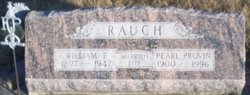
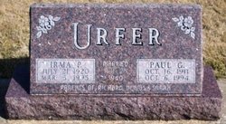
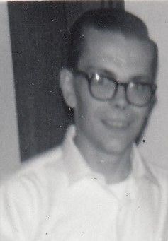
Irma Pearl Rauch Urfer
| Birth | : | 21 Jul 1920 Victor, Iowa County, Iowa, USA |
| Death | : | 5 Mar 1995 Malcom, Poweshiek County, Iowa, USA |
| Burial | : | New Hope Cemetery, Marion, Cole County, USA |
| Coordinate | : | 38.6955872, -92.3943558 |
| Plot | : | Block XXII lot 43 |
| Description | : | Mother of Richard, Dennis and Sarah Mrs. Irma P. Urfer, 74, of Malcom, formerly of Brooklyn, died Sunday, March 5, 1995. in her home in Malcom. Mrs. Urfer had moved the previous day from Brooklyn where she and her late husband, Paul Urfer, had lived many years. Funeral services for Mrs. Urfer were held at 10:30 a.m. March 8, 1995, in the First Presbyterian Church, Brooklyn. Rev. James B. Rea officiated. Burial was in the Brooklyn Cemetery. Irma Pearl Rauch Urfer, daughter of William Rauch and Pearl Provin Rauch, was born July 21, 1920, at Victor. Mrs. Urfer received her education... Read More |
frequently asked questions (FAQ):
-
Where is Irma Pearl Rauch Urfer's memorial?
Irma Pearl Rauch Urfer's memorial is located at: New Hope Cemetery, Marion, Cole County, USA.
-
When did Irma Pearl Rauch Urfer death?
Irma Pearl Rauch Urfer death on 5 Mar 1995 in Malcom, Poweshiek County, Iowa, USA
-
Where are the coordinates of the Irma Pearl Rauch Urfer's memorial?
Latitude: 38.6955872
Longitude: -92.3943558
Family Members:
Parent

Spouse
Siblings
Children

Flowers:


Nearby Cemetories:
1. New Hope Cemetery
Marion, Cole County, USA
Coordinate: 38.6955872, -92.3943558
2. Old Marion Cemetery
Marion, Cole County, USA
Coordinate: 38.7065506, -92.3792801
3. Mary Ann Williams Cemetery
California, Moniteau County, USA
Coordinate: 38.6988200, -92.4327900
4. Hickman Cemetery
Marion, Cole County, USA
Coordinate: 38.6776300, -92.3595600
5. Shull Cemetery
Moniteau County, USA
Coordinate: 38.7296982, -92.3972015
6. Shull Cemetery
Cole County, USA
Coordinate: 38.7296982, -92.3974991
7. Bailey Farm Cemetery
Marion, Cole County, USA
Coordinate: 38.6680330, -92.3553800
8. Shiloh Christian Church Cemetery
California, Moniteau County, USA
Coordinate: 38.6951800, -92.4502300
9. Cook Cemetery
Moniteau County, USA
Coordinate: 38.7393990, -92.4080963
10. Knife Cemetery
Marion, Cole County, USA
Coordinate: 38.6681200, -92.3417300
11. Goshen Primitive Baptist Church Cemetery
Wilton, Boone County, USA
Coordinate: 38.7346600, -92.3550000
12. Sweetwater Cemetery
Moniteau County, USA
Coordinate: 38.6567001, -92.4411011
13. Kubli Chapel Cemetery
Jamestown, Moniteau County, USA
Coordinate: 38.7417300, -92.4295200
14. John D. Williams Cemetery
Sandy Hook, Moniteau County, USA
Coordinate: 38.7545600, -92.4098800
15. New Hope Cemetery
California, Moniteau County, USA
Coordinate: 38.6792800, -92.4774100
16. Steeley Cemetery
Elston, Cole County, USA
Coordinate: 38.6530883, -92.3282420
17. Friedens Cemetery
Hartsburg, Boone County, USA
Coordinate: 38.6986000, -92.3087000
18. Steeley Cemetery
Moniteau County, USA
Coordinate: 38.6530991, -92.3281021
19. Miller Cemetery
Sandy Hook, Moniteau County, USA
Coordinate: 38.7618600, -92.4168100
20. Centertown Cemetery
Centertown, Cole County, USA
Coordinate: 38.6188660, -92.4031677
21. Elias Chambers Burial Ground
Elston, Cole County, USA
Coordinate: 38.6320600, -92.3362300
22. Chambers Cemetery
Elston, Cole County, USA
Coordinate: 38.6166153, -92.3853836
23. Maupin Cemetery
Sandy Hook, Moniteau County, USA
Coordinate: 38.7735800, -92.4196400
24. Evangelical Lutheran Emanuel Cemetery
Centertown, Cole County, USA
Coordinate: 38.6173820, -92.4191208