
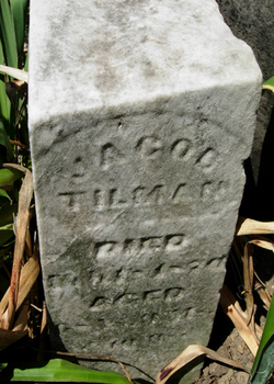
Jacob Tilman
| Birth | : | 8 May 1801 |
| Death | : | 18 Feb 1870 |
| Burial | : | Pioneers Memorial Park, Leichhardt, Inner West Council, Australia |
| Coordinate | : | -33.8780800, 151.1575000 |
| Description | : | Find A Grave contributor Mary Wilhelm Hinchman has made a suggestion to you regarding your Find A Grave memorial for Jacob Tilman. Link to contributor profile: http://www.findagrave.com/cgi-bin/fg.cgi?page=mr&MRid=47042015 Email address of contributor: [email protected] Their suggestion: ------------------------- Jacob Tilman b 5-8-1801 TN, d 2-18-1870 IN s/o Tobias Tillman 24385394 and Catherine Sharp Tillman 24385395 mar Mary Polly Magdaline Thomas 6-13-1822 Preble Co., OH ------------------------- |
frequently asked questions (FAQ):
-
Where is Jacob Tilman's memorial?
Jacob Tilman's memorial is located at: Pioneers Memorial Park, Leichhardt, Inner West Council, Australia.
-
When did Jacob Tilman death?
Jacob Tilman death on 18 Feb 1870 in
-
Where are the coordinates of the Jacob Tilman's memorial?
Latitude: -33.8780800
Longitude: 151.1575000
Family Members:
Parent
Spouse

Siblings
Children
Flowers:


Nearby Cemetories:
1. Pioneers Memorial Park
Leichhardt, Inner West Council, Australia
Coordinate: -33.8780800, 151.1575000
2. Balmain Catholic Cemetery (Defunct)
Leichhardt, Inner West Council, Australia
Coordinate: -33.8797270, 151.1523730
3. St Thomas Becket Churchyard
Lewisham, Inner West Council, Australia
Coordinate: -33.8928760, 151.1480490
4. St David’s Presbyterian Cemetery
Haberfield, Inner West Council, Australia
Coordinate: -33.8823220, 151.1378500
5. St Luke's Anglican Church
Enmore, Inner West Council, Australia
Coordinate: -33.8989218, 151.1700724
6. St. John's Anglican Church Cemetery
Ashfield, Inner West Council, Australia
Coordinate: -33.8817160, 151.1278730
7. Camperdown Cemetery
Newtown, City of Sydney, Australia
Coordinate: -33.8942220, 151.1804900
8. St. Peters Cooks River Cemetery
Saint Peters, Inner West Council, Australia
Coordinate: -33.9139390, 151.1775670
9. Old Sydney Burial Ground
Sydney, City of Sydney, Australia
Coordinate: -33.8731750, 151.2063850
10. Devonshire Street Cemetery (Defunct)
Sydney, City of Sydney, Australia
Coordinate: -33.8828080, 151.2066180
11. St. Paul's Anglican Church Cemetery
Canterbury, Canterbury-Bankstown Council, Australia
Coordinate: -33.9081600, 151.1236000
12. St. Luke's Anglican Church Columbarium
Concord, Canada Bay City, Australia
Coordinate: -33.8678417, 151.1068448
13. Gladesville Asylum Cemetery
Gladesville, Hunter's Hill Municipality, Australia
Coordinate: -33.8393010, 151.1342490
14. Parish Church of Saint James
Sydney, City of Sydney, Australia
Coordinate: -33.8693760, 151.2111540
15. St Paul's Anglican Church
Burwood, Burwood Municipality, Australia
Coordinate: -33.8816114, 151.1027492
16. St. Mary's Roman Catholic Church Cemetery
Concord, Canada Bay City, Australia
Coordinate: -33.8677100, 151.1024300
17. Saint Mary's Cathedral
Sydney, City of Sydney, Australia
Coordinate: -33.8708540, 151.2135820
18. St Aidan's Anglican Church
Longueville, Lane Cove Municipality, Australia
Coordinate: -33.8281510, 151.1709560
19. Royal Botanic Gardens
Sydney, City of Sydney, Australia
Coordinate: -33.8647440, 151.2170610
20. Longbottom Cemetery
Concord, Canada Bay City, Australia
Coordinate: -33.8596140, 151.0986280
21. Mary MacKillop Memorial Chapel
North Sydney, North Sydney Council, Australia
Coordinate: -33.8388250, 151.2049160
22. St. Thomas Anglican Cemetery
Enfield, Burwood Municipality, Australia
Coordinate: -33.8912070, 151.0916610
23. Garden Island
Potts Point, City of Sydney, Australia
Coordinate: -33.8613635, 151.2280308
24. Gore Hill Cemetery
St Leonards, North Sydney Council, Australia
Coordinate: -33.8229500, 151.1887590